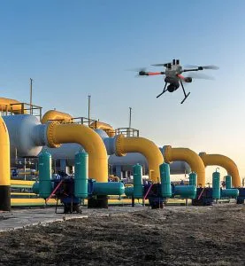
 Pipeline surveillance and protection in Port Harcourt.
Port Harcourt sits within one of Nigeria’s most important oil and gas regions. Pipelines connect production areas, processing facilities, storage sites and other energy infrastructure across the Niger Delta.
Protecting these networks requires more than occasional patrols. A structured pipeline surveillance framework can combine field intelligence, GIS, drone monitoring, remote sensing and risk analysis to provide a clearer picture of pipeline conditions and surrounding activities.
Why Pipeline Surveillance Matters
Pipeline corridors can face several types of risks. These include physical damage, illegal interference, environmental hazards, land-use changes and activities around rights-of-way.
The scale of these networks makes continuous ground monitoring difficult. A structured approach can therefore help organizations prioritize surveillance and direct resources toward areas that require closer attention.
In 2026, NNPC described its pipeline security approach as an integrated model involving intelligence, surveillance, security deployment, regulatory oversight and community-based surveillance. This reflects the need to combine multiple sources of information rather than rely on a single monitoring method.
Building a Structured Pipeline Surveillance Framework
A practical framework can organize monitoring into several connected layers.
1. Asset mapping
The first step involves creating an accurate digital inventory of pipelines, valves, facilities, access roads and other relevant infrastructure.
GIS provides a central environment for managing these spatial datasets.
2. Risk mapping
Analysts can combine pipeline locations with terrain, settlements, roads, waterways, environmental features and historical incidents.
This can help identify areas that require increased monitoring.
3. Routine surveillance
Field teams and drone operators can inspect selected pipeline corridors. High-resolution aerial imagery can reveal visible changes around exposed infrastructure and rights-of-way.
Recent UAV research has demonstrated the potential for automated detection of pipelines and visually observable anomalies, supporting faster inspection of large corridors.
4. Remote sensing and change detection
Satellite imagery can provide wider-area coverage. Analysts can compare images from different dates to identify changes around pipeline corridors.
This approach can help flag new construction, land disturbance, vegetation changes and other features for further investigation.
5. Reporting and response
Surveillance becomes more useful when teams can quickly convert observations into actionable information.
A GIS dashboard can display inspection locations, detected changes, risk zones and previous observations. This gives decisionmakers a spatial view of the pipeline network and its monitoring history.
The Role of Drones and GIS
Drone technology adds a high-resolution layer to pipeline surveillance. Operators can capture detailed imagery over selected sections of a corridor without relying entirely on conventional ground inspections.
GIS then provides the framework for organizing and analyzing the resulting data.
Research on drone-integrated GIS applications has identified pipeline inspection, leak detection, corrosion monitoring and surveillance of activities around pipeline corridors as important applications.
The technology can also support environmental monitoring. Satellite remote sensing research in the Niger Delta has demonstrated how Earth observation can help analyze oil-spill impacts and changes around pipeline networks.
Moving Towards Predictive Pipeline Monitoring
A mature surveillance system can go beyond detecting what has already happened.
Historical inspection records, remote sensing imagery, terrain information and incident data can support risk modelling. Organizations can use these datasets to identify patterns and prioritize future inspections.
Advanced systems can also incorporate artificial intelligence and automated change detection. However, automated alerts should support human inspection and operational decision-making rather than replace it.
Geospatial Intelligence for Pipeline Protection
Pipeline protection depends on knowing where assets are, understanding what surrounds them and detecting meaningful changes over time.
GIS, drone mapping, satellite imagery and spatial analytics can bring these capabilities together within a structured monitoring framework.
For organizations managing oil and gas infrastructure, GeoInfotech provides geospatial technology services that connect surveying, drone mapping, remote sensing, GIS and spatial analysis.
As Port Harcourt and the wider Niger Delta continue to support Nigeria’s energy sector, structured geospatial surveillance can provide the information needed to monitor infrastructure, identify emerging risks and support more informed asset-management decisions.