Flood Modeling Project 2019
Location: Osun ILE-IFE Nigeria

Project Type: Training
Project Size: Medium

Geoinfotech 2019 Professional

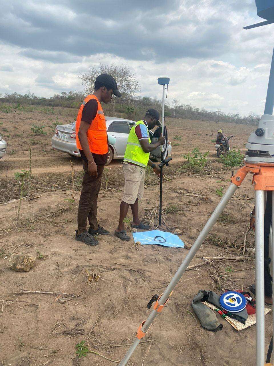
Conducted for some Afrigist Students, also engaged in proffering a flood base analysis. We put together data, and their equipment’s that teaches and equip personnel’s with the best and latest technical know-how
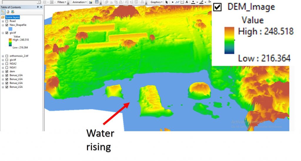


Across the globe, floods have posed a tremendous danger to people’s lives and properties. Floods cause about one-third of all deaths, one-third of all injuries and one-third of all damage from natural disasters (Askew, 1999). In Nigeria, the pattern is similar to the rest of the world. Flooding in various parts of Nigeria have forced millions of people from their homes, destroyed businesses, polluted

Remote Sensing can be very effective for flood management in two ways; firstly by detailed mapping that is required for the production of hazard assessment maps, hence for input to various types of hydrological models, and secondly by developing a larger scale view of the general flood situation within a river basin with the aim of identifying areas at greatest risk and in the need of immediate assistance.

Globally, disasters are said to have a devastating effect on economic development, livelihoods, agriculture, and health, social and human life (Wood, 2005). They are sudden, accidental events that may cause deaths or injuries. Udoh (2015 ).

Flood disaster is not a recent phenomenon in Nigeria and its destructive tendencies are sometimes enormous ( and Udo 2015).

Date: November 13, 2019
Osun Flood Mapping

Land, Drone, GIS Consultants in Nigeria

Dealing with land issues in Nigeria can be tough because of property disputes, legal paperwork,...

COMPANIES TO CONSULT ON LAND MATTERS

Land matters in Nigeria can be very complicated, involving issues like property disputes and...

PREVIOUS PROJECTS & ACTIVITIES

Geoinfotech has also been at the frontier of several GIS, Drone and Remote sensing based projects

Top 5 most violent states in Nigeria and their emergency centers

3D Diorama of the straits of Mackinac

 DETAILED AERIAL, LAND SURVEY AND GIS ANALYSIS FOR ADVANCED REAL ESTATE DEVELOPMENT

 DETAILED AERIAL, LAND SURVEY AND GIS ANALYSIS FOR ADVANCED REAL ESTATE DEVELOPMENT

Professional Drone Mapping and GIS Training For ETA-ZUMA Mining Company

Professional Drone Mapping and GIS Training For ETA-ZUMA Mining Company

Installation of Intelligent Traffic Lights

Installation of Intelligent Traffic Lights

Geological Report on a Mining/Exploration Survey

Geological Report on a Mining/Exploration Survey

Drone Survey and Mapping of Shaishen Foods Limited

Drone Survey and Mapping of Shaishen Foods Limited

Lidar Topographic Mapping Project

Lidar Topographic Mapping Project

Geophysical/hydrogeophysical Studies for Groundwater Development

Geophysical/hydrogeophysical Studies for Groundwater Development

Togo Digital Terrain Model Project

Togo Digital Terrain Model Project

Drone Mapping of Parts of Lome Rail Line for Graceland Energy Located at Lome Togo

Drone Mapping of Parts of Lome Rail Line for Graceland Energy Located at Lome Togo

Drone/land Survey of Pure-chem Industrial Limited, Ogun State.

Drone/land Survey of Pure-chem Industrial Limited, Ogun State.

Drone Inspection/survey of Southern Lake Estate, Chevron, Lekki, Lagos State

Drone Inspection/survey of Southern Lake Estate, Chevron, Lekki, Lagos State

Topographic Mapping of Oyo State

Topographic Mapping of Oyo State

Topographic Mapping of Part of the Local Government Areas in Oyo State

Topographic Mapping of Part of the Local Government Areas in Oyo State

Topographic Mapping of Part of Kwara, Ekiti and Kogi State Local Government Area

Topographic Mapping of Part of Kwara, Ekiti and Kogi State Local Government Area

Political Map of South West, Nigeria Located in Nigeria

Political Map of South West, Nigeria Located in Nigeria

Topographic Mapping of Parts of Niger State Located at Niger State, Nigeria

Topographic Mapping of Parts of Niger State Located at Niger State, Nigeria

Topographic Mapping of Part of Kwara, Ekiti, and Kogi State Local Government Area Located in Nigeria

Topographic Mapping of Part of Kwara, Ekiti, and Kogi State Local Government Area Located in Nigeria

Topographic Mapping of Part of Kwara State Local Government Area Located at Kwara State Nigeria

Topographic Mapping of Part of Kwara State Local Government Area Located at Kwara State Nigeria

Flood Analysis of Amuwo-odofin Orthophoto.

Flood Analysis of Amuwo-odofin Orthophoto.

Site Inspection Using Drone of Water Corporation Located at Oke-aro Agege

Site Inspection Using Drone of Water Corporation Located at Oke-aro Agege

24,000 meter Lome Rail Line for Drone Mapping, Graceland Energy Located at Lome, Togo

24,000 meter Lome Rail Line for Drone Mapping, Graceland Energy Located at Lome, Togo

10 Drone Inspection Traffic Signal in Lagos

10 Drone Inspection Traffic Signal in Lagos

Osun state parcel project

Osun state parcel project

Drone Mapping & Vectorization Of Abu-allied Farm

Drone Mapping & Vectorization Of Abu-allied Farm

Proposal for aerial deployment, tracking and monitoring of threats in victoria island phase 1 and ikoyi phase 2, nigeria

Proposal for aerial deployment, tracking and monitoring of threats in victoria island phase 1 and ikoyi phase 2, nigeria

Jabi Lake Mall Solar Inspection – Abuja

Jabi Lake Mall Solar Inspection – Abuja

Ground Control and Drone Survey for Mast 3D Modeling

Ground Control and Drone Survey for Mast 3D Modeling

Telecom Drone 3D and 2D Modeling of Cellsite

Telecom Drone 3D and 2D Modeling of Cellsite

800 Building Plots Aerial Capture and Delineation for Database. Greenfield Estate

800 Building Plots Aerial Capture and Delineation for Database. Greenfield Estate

100 Hectares Aerial Survey with Differential GPS of High Accuracy

100 Hectares Aerial Survey with Differential GPS of High Accuracy

Protected: Nigeria Crime Report and Dashboard

Protected: Nigeria Crime Report and Dashboard

Drone Survey and Mapping – Victoria Island  Copy

Drone Survey and Mapping – Victoria Island Copy

Akwa-Ibom 500 Hectares Drone Survey and Mapping in Nigeria

Akwa-Ibom 500 Hectares Drone Survey and Mapping in Nigeria

Ground Control Establishment – Republic of the Niger – Kano, Kastina, Jigawa, Kaduna

Ground Control Establishment – Republic of the Niger – Kano, Kastina, Jigawa, Kaduna

Drone Survey and Mapping – Victoria Island

Drone Survey and Mapping – Victoria Island

Control Point Establishment – DGPS

Control Point Establishment – DGPS

Land Survey – Northern Nigeria

Land Survey – Northern Nigeria

Biodiversity Mapping – Sweden

Biodiversity Mapping – Sweden

Flood Impact Mapping – United Kingdom

Flood Impact Mapping – United Kingdom

M and E GIS Dashboard for Control Establishment Project

M and E GIS Dashboard for Control Establishment Project

Geodatabase Management System Training For National Boundary Commission

Geodatabase Management System Training For National Boundary Commission

Nigeria Topographic Map – Project

Nigeria Topographic Map – Project

Abuja Training on Introduction to GIS

Abuja Training on Introduction to GIS

200 Hectares Land and Drone Survey – Lagos Nigeria

200 Hectares Land and Drone Survey – Lagos Nigeria

Inspection of 30 hectares drainage

Inspection of 30 hectares drainage

Drainage Drone Mapping and Surveying in Lagos Nigeria

Drainage Drone Mapping and Surveying in Lagos Nigeria

GIS Cadastral Mobile Application

GIS Cadastral Mobile Application

Abuja Topographical Map – HD GIS Mapping

Abuja Topographical Map – HD GIS Mapping

Ground Topography Survey (Lagos Island)

Ground Topography Survey (Lagos Island)

2.7km2 Topography Survey in Snake Island

2.7km2 Topography Survey in Snake Island

Sokoto Contour Map

Sokoto Contour Map

NDVI Vegetation Assessment in Lagos State

NDVI Vegetation Assessment in Lagos State

Ifako drone topographic survey and mapping

Ifako drone topographic survey and mapping

CMD Lagos 3D mapping aerial modeling

CMD Lagos 3D mapping aerial modeling

GIS and Drone Masterclass

GIS and Drone Masterclass

Drone aerial survey and mapping – Lagos Island _ Somolu

Drone aerial survey and mapping – Lagos Island _ Somolu

Covid-19 | Nigeria Data Visualisation

Covid-19 | Nigeria Data Visualisation

Benue Flood Analysis

Benue Flood Analysis

Aerial photography Ile-Ife Osun State

Aerial photography Ile-Ife Osun State

Kenya Forest Project

Kenya Forest Project

Tunsun Consultants Ltd

Tunsun Consultants Ltd

Introduction To Gis In Maritime at the National Boundary Commission

Introduction To Gis In Maritime at the National Boundary Commission

Training on GIS and Drone Mapping (batch-4 & 5)

Training on GIS and Drone Mapping (batch-4 & 5)

Osun Flood Mapping

Osun Flood Mapping

Lahass International Limited

Lahass International Limited

Linguistic Association of Nigeria

Linguistic Association of Nigeria

West African Indexing Services

West African Indexing Services

Lagos Ikeja Road Network Map

Lagos Ikeja Road Network Map

LASU Land Regularisation Portal

LASU Land Regularisation Portal

Lingua Plus International

Lingua Plus International

Lagferry Web Route

Lagferry Web Route

YOU MAY ALSO LIKE...

Request

Training Programme

Training Venue

Services

About Geoinfotech

Support / Services