 Geoinfotech was awarded a contract to map and survey to survey with the use drone, to produce orthophotos, produce points cloud and contours at a scale of 1:1000.
The specific objectives were to:
1. ensure reconnaissance survey, preflight checklist and flight plan before every aerial capture
2. guarantee the quality and standardization of every marker or GCPs and installation within the campsite
3. conduct Aerial survey with drone
 4. ensure images are captured with less than 2 cm pixel on clear days without clouds or rain
5. capture geotagged images (positional coordinates) organized by day and by drone
6. Produce orthophotos, produce points cloud and contours at a scale of 1:1000 (Coordinates System in UTM32 with EGM2008)
7. Stakeout 5 beacons sent in the campsite area with GNSS receivers and accessories
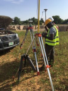
Field Work


RESULT

The result was delivered with great accuracy in centimeters. Covering the Northern Zone of Nigeria.
The Scope of the project encompasses:
1. Aerial Surveying with the drone including 200m around the Site.
2. Produce orthophotos, produce points cloud and contours at a scale of 1:1000 with the Coordinates System in UTM32 Minna Datum and vertical datum of EGM2008
3. Stakeout 5 beacons sent in the campsite area


