Clients


Why Choose Us
Geographic Information System
Data Capture, Database Management, Analysis and Mapping
Drone (Unmanned Areal Vehicle)
Surveying, Inspection, Surveillance and Mapping
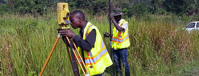
Land Suveying & Geotechnical Engineering
Topographical, Cadastral and Engineering
GIS Software Development
Design and Develop custom GIS software solutions that empower organizations make smarter decision-making
Our Services
We take your industry to the next level. Support Service Geoinfotech

Our Portfolio
Professional Drone Training Program for Enhanced Corporate Security Operations at Sahara Group
Drone categories, Drone Operation and mapping, Geographic Information System (GIS) category, GIS and Remote sensing, Organization Training, Training and Workshop
Professional Drone Training Program for Enhanced Corporate
Drone categories, Drone Operation and mapping,
Professional Drone Training Program for Enhanced Corporate
Drone categories, Drone Operation and mapping,
Professional Drone Training Program for Enhanced Corporate
Drone categories, Drone Operation and mapping,
Professional Drone Training Program for Enhanced Corporate
Drone categories, Drone Operation and mapping,
Professional Drone Training Program for Enhanced Corporate
Drone categories, Drone Operation and mapping,
Professional Drone Training Program for Enhanced Corporate
Drone categories, Drone Operation and mapping,

What our Clients Say
Committed to on-time product delivery, accurate and precise data.
100+Total Clients
260+Projects Completed
30+Total Staff
22+States Covered
Quadree Akanni
The Polytechnic Ibadan
Geographic Information System GIS
Quadree Akanni
The Polytechnic Ibadan
Geographic Information System GIS