ABSTRACT
The Strait of Hormuz is one of the most strategically important oil transit chokepoints in the global energy system, serving as a major route for crude oil exports from Gulf-producing countries to international markets. Any disruption or closure of the strait has the potential to affect global oil supply, increase crude oil prices, and influence oil-dependent economies across the world. This study assesses the potential impact of a Strait of Hormuz closure on global oil supply and examines its implications for the Nigerian oil economy using a geospatial and analytical framework. Vessel tracking data, maritime route mapping, and supporting energy market reports were integrated within ArcGIS Pro to analyze oil transportation patterns and the indirect economic relationship between the Gulf region and Nigeria.
The findings reveal that although Nigeria does not directly depend on oil transported through the Strait of Hormuz, the country remains economically linked to the same international oil market. A closure of the strait would likely tighten global crude oil supply, increase oil prices, and generate both positive and negative effects on Nigeria. Higher oil prices may increase export earnings and government revenue, while rising refined petroleum import costs could increase domestic fuel prices and inflationary pressure. The study demonstrates the importance of GIS-based maritime route analysis in understanding global oil transportation systems and evaluating the indirect economic effects of energy supply disruptions.
Keywords: Strait of Hormuz, Global Oil Supply, Nigerian Oil Economy, GIS, ArcGIS Pro, Vessel Tracking, Maritime Routes, Oil Price Disruption, Energy Security
1.0 INTRODUCTION
Global economic growth and industrial development depend heavily on stable energy supply systems. Among the various energy resources used across the world, crude oil remains one of the most important sources of energy for transportation, manufacturing, electricity generation, and industrial production. Because global oil consumption continues to increase, international oil transportation systems have become highly strategic to the stability of the world economy.
A major component of global oil transportation is maritime shipping. Large quantities of crude oil and petroleum products are transported daily through international maritime routes connecting oil-producing regions to consuming nations. These routes often pass through narrow waterways known as maritime chokepoints. Maritime chokepoints are strategic passages through which a substantial proportion of globally traded oil flows. According to Komiss and Huntzinger (2011), disruptions in these chokepoints can create major economic consequences by reducing oil supply, increasing transportation costs, and destabilizing global energy markets.
Among all global maritime chokepoints, the Strait of Hormuz is regarded as one of the most important and sensitive oil transit corridors in the world. The strait connects the Persian Gulf to the Arabian Sea and serves as the primary export route for crude oil and liquefied natural gas from major Gulf-producing countries such as Saudi Arabia, Iraq, Kuwait, Qatar, and the United Arab Emirates. The U.S. Energy Information Administration reported that approximately one-fifth of globally traded oil passes through the Strait of Hormuz daily, making it one of the busiest energy corridors in the world.
The strategic importance of the Strait of Hormuz has made the region highly vulnerable to geopolitical tensions, military confrontations, piracy threats, and energy-security concerns. Ramadhani and Marzaman (2024) explained that the Strait of Hormuz functions as a critical global energy chokepoint whose instability can significantly influence international trade, maritime stability, and global oil prices. Political tensions involving Iran, the United States, Saudi Arabia, Israel, and other Gulf-region actors have increased fears regarding the possibility of disruption or closure of the strait.
Historical events also demonstrate the vulnerability of the Strait of Hormuz to conflict and maritime insecurity. During the Iran-Iraq Tanker War between 1983 and 1988, attacks on oil tankers significantly reduced maritime traffic and raised concerns regarding global energy supply security. Komiss and Huntzinger (2011) noted that Iran attacked hundreds of vessels during the conflict, leading to a reduction in tanker movement within the Gulf region. Although complete closure of the strait did not occur, the conflict demonstrated how geopolitical instability in the Gulf region can affect global oil transportation systems.
In recent years, renewed tensions involving Iran, Israel, and the United States have further increased global concerns over the security of the Strait of Hormuz. Reuters (2026a) reported that fears of supply disruption in the Gulf region contributed to increases in global crude oil prices and stronger geopolitical risk premiums. Reuters (2026b) also noted that energy analysts revised Brent crude oil-price forecasts upward due to concerns over possible disruption of oil flows through the strait.
The significance of the Strait of Hormuz extends beyond the Middle East because global oil markets are highly interconnected. A disruption in one strategic oil corridor can create ripple effects across economies worldwide. Countries that depend heavily on oil imports may experience increased transportation costs, inflation, energy shortages, and economic instability. Even countries that are geographically distant from the Gulf region can experience indirect economic consequences through fluctuations in global oil prices.
Nigeria represents one of the countries indirectly connected to the Strait of Hormuz through the international oil market system. Nigeria is one of Africa’s leading crude oil exporters and depends heavily on petroleum revenue for foreign exchange earnings and government income. Although Nigeria exports crude oil mainly through Atlantic maritime routes rather than through the Strait of Hormuz, changes in global oil prices significantly influence the Nigerian economy.
At the same time, Nigeria remains heavily dependent on imported refined petroleum products despite being a major crude oil producer. Consequently, increases in global oil prices resulting from disruptions in the Strait of Hormuz may generate mixed economic effects for Nigeria. While higher oil prices could increase crude oil export earnings and government revenue, they may also increase domestic fuel prices, transportation costs, and inflationary pressure.
Furthermore, growing concerns regarding global energy security have encouraged increased interest in maritime monitoring, geopolitical risk analysis, and geospatial intelligence for energy planning. GIS and spatial analysis techniques provide useful tools for understanding maritime transportation systems, identifying strategic oil routes, and evaluating the possible consequences of disruptions within major energy corridors.
This study therefore examines the potential impact of a Strait of Hormuz closure on global oil supply and evaluates the implications for the Nigerian oil economy using geospatial analysis, maritime route interpretation, and supporting energy market information.
1.1 Aim of The Study
The aim of this study is to assess the potential impact of a closure of the Strait of Hormuz on global oil supply and to examine its implications for the Nigerian oil economy.
1.2 Objectives of The Study
The objectives of the study are to:
- Examine the strategic importance of the Strait of Hormuz in global oil transportation
- Analyze the likely effect of a closure on global oil supply and market prices.
- Assess the implications of rising global oil prices for Nigeria’s crude oil exports and government revenue; and
- Evaluate the possible economic challenges Nigeria may face as a result of higher refined fuel import costs.
2.0 METHODOLOGY
2.1 Study Area
The study focuses on the Strait of Hormuz region and its connection to global oil transportation networks. The Strait of Hormuz lies between Iran and Oman and serves as the only sea passage linking the Persian Gulf to the Arabian Sea. It functions as a major global energy chokepoint through which a significant percentage of internationally traded crude oil passes daily.
The study also considers Nigeria within the context of the international oil market. Nigeria exports crude oil mainly through Atlantic maritime routes toward Europe and other international markets. Although Nigeria is geographically distant from the Gulf region, both areas remain connected through global oil pricing systems and international energy trade.
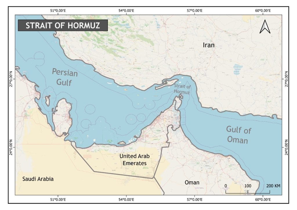
Figure 2.0: Study Area
2.2 Data Acquisition and Sources
The data used for this study were obtained from vessel tracking platforms, geospatial datasets, maritime route maps, and supporting energy market reports.
2.2.1 Acquisition of Vessel Route Data
Vessel tracking data were obtained from Global Fishing Watch to identify tanker movement patterns across major maritime transportation corridors. These datasets were used to observe and interpret routes associated with international oil transportation.
2.2.2 Acquisition of Geospatial Data
Additional spatial datasets such as country boundaries, maritime route layers, and location points were integrated within ArcGIS Pro for spatial visualization and route analysis.
2.2.3 Acquisition of Supporting Energy Market Information
Supporting materials including Reuters energy reports, oil market updates, trade-related information, and reports from the U.S. Energy Information Administration were reviewed to explain the possible consequences of a Strait of Hormuz closure on global oil supply and the Nigerian oil economy.
2.3 Analytical Technique
The study adopted spatial analysis and route interpretation techniques to evaluate the relationship between the Strait of Hormuz and the Nigerian oil economy.
2.3.1 Spatial Analysis
Spatial analysis was conducted using ArcGIS Pro to visualize maritime oil transportation routes and represent the connection between the Strait of Hormuz and global oil markets. The analysis involved route mapping, spatial interpretation, and cartographic visualization.
2.3.2 Vessel Route Mapping
Vessel route data obtained from Global Fishing Watch were interpreted and converted into route representations showing tanker movement toward Europe and Asia. These routes were used to demonstrate the strategic importance of the Strait of Hormuz within the global oil transportation network.
2.3.3 Route Digitization
Digitization techniques were used to create and refine route lines showing oil tanker movement from the Gulf region toward international markets. Nigeria’s crude oil export routes were also represented to illustrate the country’s indirect relationship with the Strait of Hormuz.
2.3.4 Spatial Interpretation
Spatial interpretation techniques were used to assess how disruptions within the Strait of Hormuz could indirectly influence Nigeria through the international oil market system.
Figure 2.1 shows the Strait of Hormuz region and the associated maritime transportation routes used in this study.
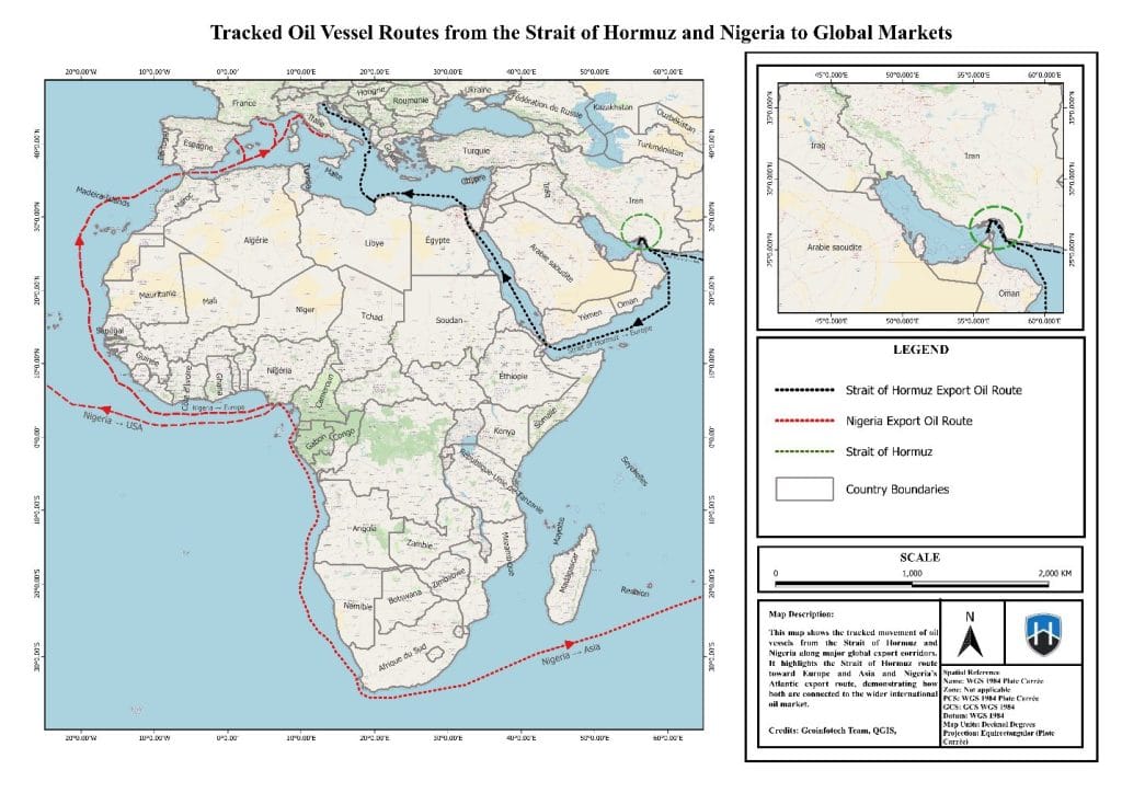
Figure 2.1: Map Showing the Strait of Hormuz Region
Figure 2.2 presents the Global Fishing Watch interface used for vessel tracking and route analysis.
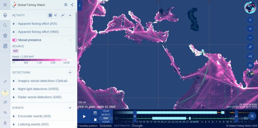
Figure 2.2: Global Fishing Watch Interface
3.0 FINDINGS AND ANALYSIS
3.1 Examination of The Strategic Importance of the Strait of Hormuz in Global Oil Transportation
The findings show that the Strait of Hormuz is one of the most strategically important corridors in global oil transportation. A substantial proportion of globally traded seaborne crude oil passes through the strait toward Europe and Asia. The mapped vessel routes indicate a strong concentration of tanker movement through the Gulf region, highlighting the dependence of international energy markets on uninterrupted transportation through the strait.
The analysis also reveals that Nigeria exports crude oil through Atlantic maritime routes rather than through the Strait of Hormuz. However, Nigeria remains economically linked to the same global oil market system.
3.2 Analysis of The Likely Effect of a Strait of Hormuz Closure On Global Oil Supply and Market Prices
The findings indicate that a closure or severe disruption of the Strait of Hormuz would likely reduce global crude oil supply and increase pressure on international oil prices. Reuters (2026a) reported that recent geopolitical tensions around the Gulf region already contributed to increased oil prices and stronger geopolitical risk premiums.
Reduced oil supply through the Strait of Hormuz would likely increase global competition for available crude oil, resulting in higher crude oil prices across international markets.
Figure 3.0: Potential impact of a strait of Hormuz closure on global supply and Nigeria’s economy
3.3 Assessment of The Implications of Rising Global Oil Prices for Nigeria’s Crude Oil Exports and Government Revenue
The findings reveal that higher global crude oil prices could positively influence Nigeria’s crude oil export earnings and government revenue. Since Nigeria depends heavily on petroleum exports for foreign exchange earnings and fiscal revenue, increases in global oil prices may improve short-term government income and export value.
The relationship between the Strait of Hormuz and Nigeria is therefore indirect but economically important because both regions operate within the same international oil market.
3.4 Evaluation of The Possible Economic Challenges Nigeria May Face as A Result of Higher Refined Fuel Import Costs
The findings further indicate that Nigeria may experience economic challenges arising from increased refined petroleum import costs. Despite being a major crude oil exporter, Nigeria still imports a significant proportion of refined petroleum products.
As global crude oil prices increase, domestic fuel prices, transportation costs, and inflationary pressure may also rise. This means that while Nigeria may benefit from increased export earnings, the country could simultaneously face economic pressure associated with higher fuel import costs.
4.0 IMPLICATIONS OF FINDINGS
The findings of this study reveal both positive and negative implications for the Nigerian economy.
On the positive side, increased global crude oil prices could improve Nigeria’s export earnings, strengthen foreign exchange inflow, and increase government oil revenue.
On the negative side, higher global oil prices may increase the cost of refined petroleum imports, transportation, and domestic energy consumption. Since Nigeria remains dependent on imported petroleum products, disruptions within the Strait of Hormuz may contribute to inflationary pressure and increased living costs.
The study therefore demonstrates that a Strait of Hormuz closure could create a mixed economic outcome for Nigeria through both increased oil revenue and increased domestic economic pressure.
5.0 CHALLENGES AND LIMITATIONS ENCOUNTERED
Several limitations affected this study. First, some vessel routes used in the analysis were generalized representations and may not capture all real-time shipping variations. Second, the study relied partly on public energy reports and geopolitical news updates, which may change rapidly as global events evolve. Third, the actual impact on Nigeria depends on additional factors such as domestic production levels, exchange rates, export performance, and the duration of any disruption.
These limitations indicate that the findings should be understood as a scenario-based analytical assessment rather than an exact prediction.
6.0 RECOMMENDATIONS
Based on the findings of this study, the following recommendations are proposed:
- Nigeria should strengthen domestic refining capacity in order to reduce dependence on imported refined petroleum products.
- Government and energy agencies should adopt GIS-based maritime route monitoring and strategic energy-risk mapping for improved planning and preparedness.
- Policymakers should reduce excessive dependence on temporary gains from global oil-price increases and strengthen economic diversification strategies.
- Energy planners should improve monitoring of international maritime chokepoints and geopolitical developments affecting global oil transportation systems
7.0 CONCLUSION
The Strait of Hormuz remains one of the most important energy chokepoints in the world. Any major disruption or closure would likely reduce global oil supply, increase crude oil prices, and destabilize international energy markets.
Although Nigeria is not directly dependent on crude oil transported through the Strait of Hormuz, the country remains economically connected to the same global oil market. Consequently, disruptions within the Gulf region could increase the value of Nigerian crude oil exports while simultaneously increasing domestic fuel-import costs and inflationary pressure.
The study therefore concludes that a Strait of Hormuz closure would present both opportunities and risks for the Nigerian oil economy. The research further demonstrates the importance of geospatial analysis and maritime route interpretation in understanding global energy disruptions and their economic implications.
REFERENCES
Aizarani. (2023). U.S. petroleum imports from Saudi Arabia between 2000 and 2021. Statista.
Antuli, R., & Abbas, H. (2022). Conflict dynamics between Saudi Arabia and Iran in Yemen. Middle East Political Review, 8(2), 44–59.
CNN Indonesia. (2022). Saudi Arabia and United States oil trade relations. CNN Indonesia.
Damayanti, R., et al. (2022). Geopolitical tensions and maritime instability in the Strait of Hormuz. International Relations Review, 6(1), 21–38.
Dunn, C., & Barden, J. (2023). World oil transit chokepoints. U.S. Energy Information Administration.
Global Fishing Watch. (2025). Vessel tracking and maritime route data. https://globalfishingwatch.org/
Komiss, W., & Huntzinger, L. (2011). The Economic Implications of Disruptions to Maritime Oil Chokepoints. CNA Analysis & Solutions.
Marcus, J. (2017). Oil politics and geopolitical competition in the Middle East. Global Energy Journal, 12(4), 77–92.
Morgenthau, H. J. (2024). Politics among nations: The struggle for power and peace. New York: McGraw-Hill.
Ramadhani, R., & Marzaman, A. (2024). Maritime stability in the Strait of Hormuz: Challenges, global impacts, and multilateral diplomacy. Hypothesis: Multidisciplinary Journal of Social Sciences, 3(2), 81–96. https://doi.org/10.62668/hypothesis.v3i02.1293
Reuters. (2026a, March 22). Oil prices rise further as Middle East conflict escalates. Reuters. https://www.reuters.com/business/energy/oil-prices-rise-further-monday-mideast-war-escalates-2026-03-22/
Reuters. (2026b, March 23). Goldman Sachs raises 2026 Brent crude forecast amid Strait of Hormuz disruption fears. Reuters. https://www.reuters.com/business/energy/goldman-sachs-raises-2026-brent-crude-average-price-forecast-by-8-85-barrel-2026-03-23/
Setiawati, D., et al. (2023). Saudi Arabia intervention and the Yemen conflict. Journal of International Conflict Studies, 5(3), 102–119.
U.S. Energy Information Administration. (2025). World oil transit chokepoints. U.S. Department of Energy.