Abstract
Agricultural suitability assessment is an important approach for sustainable land use planning and agricultural development. This study presents a spatial modelling framework for agricultural suitability in Etche Local Government Area, Rivers State, Nigeria, using Multi-Criteria Decision Analysis (MCDA), Analytical Hierarchy Process (AHP), Geographic Information Systems (GIS), and GeoAI-inspired geospatial processing. These Six environmental criteria which includes: soil properties (pH, texture, organic carbon), slope, rainfall, temperature, NDVI, and land use/land cover were used to conduct this analysis. The datasets were acquired and processed using Google Earth Engine (GEE), ensuring efficient multi-source data integration and spatial consistency. AHP was used to assign weights to each criterion, while weighted overlay was applied to generate a continuous suitability index, later generalized into suitability classes. The final suitability analysis shows the land to be quite acceptable for agricultural practices. It was found that over 27% of the area was highly suitable, 22% moderately suitable, 29% marginally suitable and just about 12% was found to be unsuitable. The reliability of this model was assessed using AHP consistency ratio, literature validation, spatial interpretation, and sensitivity analysis. The result shows that the model is stable under minor weight variations. This study also demonstrates that integrating GIS-based MCDA with GeoAI-enabled geospatial processing provides a good and scalable framework for agricultural suitability assessment and land use planning for future purposes.
Keywords
Agricultural suitability; Multi-Criteria Decision Analysis (MCDA); Analytical Hierarchy Process (AHP); Geographic Information Systems (GIS); Google Earth Engine; GeoAI; Weighted overlay; Sensitivity analysis; Land use planning.
LIST OF TABLES
Table 1. Summary of Data Sources used
Table 2: Criteria Influence on Agriculture
Table 3: Continuous Suitability Index
Table 4: Classification of Suitability Index and Associated Interpretations
Table 5a: Relative Importance of Soil Components (AHP-Derived Weights) – Weights of soil pH, soil texture, and SOC used to create the composite soil suitability layer for the weighted overlay analysis.
Table 5b: Pairwise Comparison Matrix of Soil Components (AHP)
Table 6. Criteria Weights Used in the Multi-Criteria Evaluation – Weights assigned to environmental criteria for the weighted overlay analysis.
Table 7. Agricultural Suitability Classification Statistics – Area and percentage distribution of each suitability class in Etche LGA.
Table 8: Final Spatial Resolution Summary
LIST OF FIGURES
Figure 1. Study Area Map – Location of Etche LGA in Rivers State, Nigeria, showing administrative boundaries and spatial extent.
Figure 2. Environmental Factors Influencing Agricultural Suitability – Panels showing (a) Land use/land cover map, (b) Slope map
Figure 3. Environmental Factors Influencing Agricultural Suitability – Panels showing (a) NDVI map, (b) Soil suitability map.
Figure 4. Environmental Factors Influencing Agricultural Suitability – Panels showing (a) Rainfall distribution map, (b) Temperature map.
Figure 5. Criteria Contribution Chart – Relative contribution of environmental criteria to the agricultural suitability model.
Figure 6. Agricultural Suitability Index Map showing (a) Land use/land cover map, (b) Slope map – Continuous suitability surface generated through weighted overlay analysis.
Figure 7. Agricultural Suitability Index Map showing (a) NDVI map, (b) Soil suitability map – Continuous suitability surface generated through weighted overlay analysis.
Figure 8. Agricultural Suitability Index Map showing (a) Rainfall distribution map, (b) Temperature map – Continuous suitability surface generated through weighted overlay analysis.
Figure 9. Final Agricultural Suitability Classification Map – Spatial distribution of suitability classes across Etche LGA.
Figure 10. Sensitivity Analysis Map – showing minimal changes in suitability classes.
TABLE OF CONTENTS
CHAPTER ONE: INTRODUCTION
1.1 Background of the Study
1.2 Statement of the Research Problem
1.3 Aim of the Study
1.4 Specific Objectives
1.5 Significance of the Study
1.6 Scope of the Study.
1.7 Study Area
CHAPTER TWO: LITERATURE REVIEW
2.1 GIS-Based Agricultural Suitability Modelling
2.2 Multi-Criteria Evaluation and the Analytical Hierarchy Process
2.3 Remote Sensing and Vegetation Indices in Agricultural Assessment
2.4 Emergence of GeoAI and Cloud-Based Geospatial Analysis
2.5 Research Gap and Study Contribution
CHAPTER THREE: METHODOLOGY
3.1 Study Area
3.2 Data Sources and Acquisition
3.3 Data Pre-processing
3.4 Criteria Selection
3.5 AHP Weight Determination
3.6 Suitability Modelling Using Weighted Overlay
3.7 Sensitivity Analysis
3.8 Model Validation / Reliability Assessment
3.9 GeoAI-Assisted Geospatial Data Processing
3.10 Suitability Classification
CHAPTER FOUR: RESULTS
4.1 Spatial Characteristics of the Study Area
4.2 Environmental Factors Influencing Agricultural Suitability
4.3 Standardization of Suitability Criteria
4.4 Agricultural Suitability Index
4.5 Final Agricultural Suitability Classification
4.6 GeoAI-Assisted Geospatial Data Processing and Input Feature Generation
4.7 Sensitivity Analysis of the Suitability Model
CHAPTER FIVE: DISCUSSION
5.1 Influence of Environmental Criteria on Agricultural Suitability
5.2 Role of Soil Properties in Agricultural Potential
5.3 Contribution of Climate and Vegetation Variables
5.4 Effect of Terrain (Slope) on Suitability Patterns
5.5 Impact of Land Use/Land Cover
5.6 Performance of MCDA-AHP Model
5.7 Contribution of GeoAI (GEE Workflow)
5.8 Model Stability and Sensitivity Analysis
5.9 Comparison with Existing Studies
CHAPTER SIX: CONCLUSION AND RECOMMENDATIONS
6.1 Conclusion
6.2 Key Findings
6.3 Policy Implications
6.4 Recommendations
6.5 Limitations of the Study
6.6 Suggestions for Future Research
REFERENCES
CHAPTER ONE
INTRODUCTION
1.1 Background of Study
On the global scale, natural constraints are limiting the land’s suitability for agriculture and cultivation practices. They consist of prevailing local climatic, soil and topographic conditions determining the available energy, water and nutrient supply for agricultural crops. Besides natural conditions, complex interactions of social, economic, political, and cultural aspects determine whether and how land is used for agriculture. (Zabel, et al., 2014).
According to Joshi et al., (2024), agriculture plays a central role in food provision, rural livelihoods, and economic stability, particularly in developing regions, where environmental conditions strongly influence productivity. Agricultural land suitability analysis (ALSA) for crop production is one of the key tools for ensuring sustainable agriculture and for attaining the current global food security goal in line with the Sustainability Development Goals (SDGs) of United Nations. (Akpoti, et al., 2019).
In Africa and tropical South America, there is just about a 120% cropland ‘reserve’. The analysis, based on climate sensitivity indicates that regions such as the southern provinces of Canada, north‐western and north‐central states of the United States, northern Europe, southern Former Soviet Union and the Manchurian plains of China are most sensitive to changes in temperature. While the Great Plains region of the United States and north‐eastern China are most sensitive to changes in precipitation and CO2. It was also noted that the tropics, mainly Africa, and other regions such as northern South America, Mexico, Central America and Oceania experiences decrease in agricultural land suitability. (Ramankutty, et al., 2002). This observed decline in agricultural land suitability across tropical regions indicates that simply having available land does not ensure its productive use, and to that effect, there is need for agricultural suitability analysis in Africa to be taken beyond land availability to incorporate climate variability, soil properties and vegetation parameters, ensuring that land-use decisions and planning are resilient, adaptive, and sustainable in the face of changing environmental conditions.
In Nigeria, the fundamental constraint of agricultural development is the poor methods of data acquisition and management on agricultural land potential, crops condition and farming activities. The consequence is poor knowledge and unreliable data for agricultural planning and policy formulation. Hence, the need to improve agricultural productively is real and urgent. (Joshua, et al., 2013).
And since not all land areas are equally suitable for improved cultivation due to climatic variations and difference in soil type and vegetation, there is need for land suitability analysis. Identifying locations where these conditions are most favorable is essential for informed land-use planning.
Multi-criteria decision-making (MCDM) is an essential approach for evaluating and prioritizing alternatives in complex decision scenarios where multiple, often conflicting criteria must be considered. (Singh and Patra, 2025). One widely adopted application strategy in GIS is Multi-Criteria Evaluation (MCE), which allows diverse spatial variables to be standardized, weighted, and combined into a composite suitability index. (Ahmed, et al., 2013).
Geographic Information Systems (GIS) provide a powerful framework for analyzing spatial variability in environmental conditions as it integrates multiple environmental factors into a unified analytical environment (Zhu, 2016). GIS contributes by enabling the spatial analysis and visualization of geographic data, which is critical for understanding spatial patterns and relationships in decision-making processes. (Singh and Patra, 2025). It enables the development of spatial decision-support tools for the assessment of land suitability in different regions in Nigeria and the world at large.
While traditional land suitability studies mostly depend on static GIS overlay techniques, recent advances in geospatial technologies have expanded analytical capabilities. Cloud-based geospatial system such as Google Earth Engine (GEE) now enable efficient processing of heavy environmental datasets, automated analysis, and reproducible spatial procedures.
According to Vijayakumar et al., (2024), GEE serves as a versatile platform for processing and visualising geospatial datasets, with its primary aim being to provide an open platform for planetary-scale geospatial analysis. Over time, GEE has proven itself as a valuable and robust tool, offering access to a wide array of imagery within a single consolidated system. Its cloud computing environment and computational power eradicate the need to store, process and analyse vast amount of satellite imagery on local computers. GEE has the potential to address some of the challenges associated with earth observation and geospatial applications, particularly in developing countries. Its development has lessened the reliance on high-speed processors and extensive storage capacities. Moreover, GEE presents users with a unique opportunity to conduct analyses with minimal financial investment and equipment requirements. The platform has showcased its capability to perform spatial and temporal analyses on global-scale data at significantly accelerated computational speed, rendering it an attractive tool for the scientific community, offering both versatility and accessibility. This growth in geospatial analysis systems align with the emergence of GeoAI concepts that improved spatial modeling through computational efficiency and intelligent data integration.
This study develops a GIS-based agricultural land suitability model for Etche LGA using Multi-Criteria Evaluation integrated with the Analytical Hierarchy Process (AHP). GIS-AHP is the most effective tool in the analysis of spatial data in the study and it provides a clear approach to multi-criteria evaluation and suitability analysis. (Wijesinghe, 2024). Long-term climatic averages, multi-year vegetation indices, soil properties, land cover, and terrain factors are incorporated to generate a spatial suitability map identifying areas of varying agricultural potential. And beyond model development, the study also examines how GeoAI-enabled geospatial procedures can strengthen land suitability assessment by improving the transparency of analytical processes, automation process, and its scalability.
In combining structured decision analysis with modern geospatial processing techniques, this study contributes to spatially informed agricultural planning and provides a reproducible framework that can be used in similar environmental contexts.
1.2 Statement of the Research Problem
Despite advancements in GIS-based agricultural suitability analysis, many researches remain limited by insufficient integration of multiple environmental factors, reliance on static datasets, and lack of robust validation frameworks. In addition, the application of cloud-based geospatial platforms such as Google Earth Engine for effective and extensible data processing is still underutilized in local-scale studies.
These limitations reduce the reliability and applicability of suitability models for effective land-use planning. As a result, there is a need for an integrated approach that combines multi-criteria evaluation, structured weighting techniques, and GeoAI-inspired geospatial processing to enhance agricultural suitability modelling.
1.3 Aim of the Study
To develop a GIS-based spatial decision support model for agricultural land suitability assessment in Etche Local Government Area, Rivers State, Nigeria.
1.4 Specific Objectives
In order to efficiently achieve the aim of this study, these objectives are outlined to enable the identification, processing and analysis of the environmental criteria for agricultural suitability assessment within the study area.
- To identify and prepare environmental criteria relevant for this research. Criteria includes rainfall, temperature, slope, elevation, soil characteristics, land use/land cover, and NDVI,
- To perform the classification of criteria into suitability classes,
- To utilize Google Earth Engine and ArcGIS for the analysis,
- To generate an agricultural land suitability map classifying land into suitability categories,
- To evaluate the percentage distribution of the agricultural suitability of the study area, and
- To validate the suitability model by conducting sensitivity analysis.
1.5 Significance of the Study
This study contributes to the advancement of agricultural land suitability assessment by providing a robust and integrated framework that combines Multi-Criteria Decision Analysis (MCDA), the Analytical Hierarchy Process (AHP), and Geographic Information Systems (GIS). The combination of multiple environmental factors, including soil properties, slope, climate variables, vegetation indices, and land use, enhances the accuracy and reliability of suitability modelling compared to single-factor approaches. The integration of GeoAI-inspired geospatial processing using Google Earth Engine improves the efficiency and reproducibility of spatial data analysis. This is particularly significant for data-limited regions, where access to large and diverse environmental datasets can be challenging.
The deliverables of this study provide valuable decision-support tools for agricultural land planners, policymakers, and land resource managers by identifying areas with varying levels of agricultural suitability. The study also contributes to academic research in various ways including demonstrating the practical integration of cloud-based geospatial technologies with traditional GIS-based MCDA approaches. It also provides a methodological reference for future studies aiming to incorporate sensitivity analysis as a robust validation technique in suitability modelling.
1.6 Scope of the Study
This study focuses on the spatial modelling of agricultural suitability within Etche Local Government Area, Rivers State, Nigeria. The analysis is based on the integration of important environmental factors influencing agricultural productivity, including soil properties (pH, texture, and soil organic carbon), slope, rainfall, temperature, normalized difference vegetation index (NDVI), and land use/land cover. The study uses a Geographic Information System (GIS)-based Multi-Criteria Decision Analysis (MCDA) framework, incorporating the Analytical Hierarchy Process (AHP) for weighting and a weighted overlay technique for suitability modelling. Environmental datasets covering the period 2015 – 2024 were utilized, with pre-processing and feature derivation conducted using Google Earth Engine to ensure consistency and efficiency in data management.
This study is limited to biophysical factors only, it does not incorporate socio-economic criteria such as market accessibility, infrastructure, or farmer preferences. Also, the study relies on secondary geospatial datasets and does not include field-based validation or ground-truth data collection. The findings are therefore intended to provide a spatial decision-support framework rather than site-specific agricultural recommendations
1.7 Study Area
Etche LGA, located in Rivers State, Nigeria, is characterized by a mix of lowland terrain, vegetative cover, and intensive agricultural activity. The area is suitable for this study due to its agricultural significance and availability of multi-source environmental datasets required for spatial modelling. (Figure1)
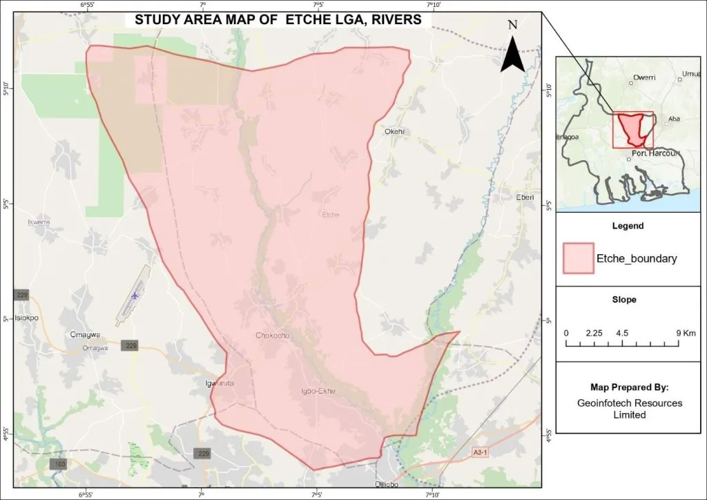
Figure 1. Study Area Map.
Location of Etche LGA in Rivers State, Nigeria, showing administrative boundaries and spatial extent.
CHAPTER TWO
LITERATURE REVIEW
2.1 GIS-Based Agricultural Suitability Modelling
Land suitability assessment is central to sustainable agricultural planning and environmental resource management. With the advancement of Geographic Information Systems (GIS), suitability analysis has evolved from qualitative evaluation methods to spatially explicit data-driven systems. GIS enables the combination of diverse environmental variables, including topography, climate, soil properties, and land cover, into structured analytical systems to support decision making (Wijesinghe, 2024).
GIS-based Multi-Criteria Decision Analysis (MCDA) has become one of the most widely adopted approaches for spatial decision-making involving multiple environmental constraints. Numerous agricultural studies in Africa, including Nigeria, have successfully applied GIS-MCDA to evaluate land suitability for crop production, irrigation planning, and rural land management (Ahmed and Kunda, 2013). Although it has significantly gained recognition, many suitability studies remain limited by the use of static weighting techniques, insufficient integration of long-term environmental datasets, and restricted local-scale analyses. These limitations reduce the reliability in the structure of suitability classifications, particularly in local regions.
2.2 Multi-Criteria Evaluation and the Analytical Hierarchy Process
Multi-Criteria Evaluation (MCE) provides a systemic method for combining heterogeneous environmental factors into a single suitability index. A critical component of MCE is the assignment of weights to criteria, reflecting their relative influence on agricultural productivity (Wijesinghe, 2024).
The Analytical Hierarchy Process (AHP), introduced by Saaty (1980), offers a systematic framework for deriving weights through pairwise comparison matrices. AHP enhances methodological transparency by quantifying subjective judgments and incorporating a consistency ratio (CR) to evaluate logical reliability. Integrating GIS with Analytical Hierarchy Process enhances the robustness of land suitability models, allowing researchers to justify weight derivation mathematically and strengthen the credibility of spatial decision-support systems. Nevertheless, some applications simplify AHP implementation or omit consistency validation, potentially weakening model reliability. A structured and validated AHP framework remains essential for reproducible suitability assessments.
2.3 Remote Sensing and Vegetation Indices in Agricultural Assessment
Remote sensing technologies also, have significantly improved monitoring of environmental indices relevant to agriculture. Vegetation indices, particularly the Normalized Difference Vegetation Index (NDVI), provide insight into vegetation health and biomass density. NDVI has been applied in crop monitoring, drought assessment, and land productivity evaluation (Tucker, 1979).
Most researches base their sturdy on single-season NDVI observations and this may not reflect long-term productivity. Incorporating multi-year NDVI averages reduces seasonal anomalies and better captures sustained vegetation performance, strengthening the empirical basis of land suitability classification.
2.4 Emergence of GeoAI and Cloud-Based Geospatial Analysis
The rapid expansion of environmental data with large datasets have contributed to the emergence of GeoAI, integrating artificial intelligence with geospatial analysis. Cloud-based platforms such as Google Earth Engine (Gorelick et al., 2017) enable large-scale analysis with access to multi-temporal satellite imagery, climate datasets, and automated processing workflows.
Integrating GeoAI-enhanced data processing into GIS-based suitability modelling improves efficiency, reproducibility, methodological transparency and structure. However, the adoption of this workflows in structured AHP-based agricultural suitability modelling at local scales is still limited in Nigeria and the Niger Delta region (Wang, 2024).
2.5 Research Gap and Study Contribution
While GIS-based multi-criteria agricultural suitability modelling is well established (Wijesinghe, 2024), several gaps persist:
- Limited use of long-term climatic averages in local-scale modelling.
- Overreliance on static or invalidated weighting schemes.
- Insufficient integration of multi-year vegetation indices.
- Minimal incorporation of GeoAI-enabled cloud-based workflows.
- Limited local-scale agricultural suitability analysis in the Niger Delta region.
This research work tends to address these gaps by developing a GIS-based agricultural land suitability model for Etche LGA, Rivers State, using long-term environmental averages, multi-year NDVI, and an AHP-derived weighting framework. Furthermore, GeoAI-assisted data processing enhances accessibility and methodological transparency, resulting in a reproducible and scalable framework for agricultural suitability assessment in data-constrained environments.
CHAPTER THREE
METHODOLOGY
3.2 Data Sources and Acquisition
This study utilizes a combination of satellite-derived environmental datasets and geospatial analysis tools. All datasets were accessed via Google Earth Engine (GEE) exported in compatible raster formats and projected into a uniform coordinate system for integration.
Environmental datasets for the study include:
- Topography: Digital Elevation Model (DEM) and derived slope from SRTM (USGS/NASA)
- Soil properties: Soil PH, texture and Soil Organic Carbon(SOC)
- Climate: Long-term rainfall and temperature averages (2015-2024).
- Vegetation: Multi-year NDVI derived from satellite imagery (2015-2024).
- Land cover: Land Use/Land Cover data from the European Space Agency (ESA) and other remote sensing sources.
Table 1: Summary of Data Sources Used
| Dataset | Provider | GEE Dataset ID | Spatial Resolution | Temporal Resolution |
| Administrative Boundary | FAO | FAO/GAUL/2015/level2 | Vector | Static |
| Sentinel-2 Surface Reflectance | ESA | COPERNICUS/S2_SR_HARMONIZED | 10 m | ~5 days |
| NDVI | Derived from Sentinel-2 | — | 10 m | Seasonal |
| Soil Texture | ISRIC | ISDASOIL/Africa/v1/texture_class | 30 m | Static |
| Soil Organic Carbon | ISRIC | ISDASOIL/Africa/v1/carbon_organic | 30 m | Static |
| Soil pH | ISRIC | ISDASOIL/Africa/v1/ph | 30 m | Static |
| Land Cover | ESA | ESA/WorldCover/v100/2020 | 10 m | 2020 |
| DEM | USGS / NASA | USGS/SRTMGL1_003 | 30 m | Static |
| Slope | Derived from DEM | — | 30 m | Static |
| Land Surface Temperature | NASA MODIS | MODIS/006/MOD11A2 | 1 km | 8-day |
3.3 Data Pre-processing
Before spatial analysis, all datasets were preprocessed to ensure compatibility and analytical consistency using ArcGIS pro.
Pre-processing steps included:
- Reprojection to a common coordinate system
- Spatial clipping to the study area boundary
- Handling missing or null values
- Standardizing all raster layers to a uniform spatial resolution
- Derivation of slope from DEM (GEE)
3.4 Criteria Selection
Key environmental factors influencing agricultural suitability were selected based on literature studies and regional relevance (Ujoh, et al. 2019).
- Slope
- Soil fertility (PH, Texture, SOC)
- Rainfall
- Temperature
- NDVI
- Land cover
Table 2: Criteria Influence on Agriculture
| Criterion | Influence on Agriculture |
| Slope | Determines soil stability and erosion risk |
| Elevation | Influences drainage and microclimate |
| NDVI | Indicates vegetation productivity |
| Rainfall | Determines water availability |
| Land Cover | Represents existing land conditions |
| Soil | Determines crop growth |
| Temperature | Influences crop growth |
Each criterion was reclassified into suitability scores ranging from low to high suitability based on the agricultural requirements and were used as input layers for the suitability model.
3.1 Study Area
Etche Local Government Area (LGA) is located in Rivers State, Nigeria, within the humid tropical Niger Delta region. It lies approximately within latitude 5.0846250⁰N and longitude 7.0815570⁰E covering approximately 811.97sqKm.
SHERDA (2009) in identifying the economic activities as well as the involvement of the people of Etche Local Government Area identified agriculture (farming) as the major economic activity of the people. (Ifeanyi-Obi, et al., 2011). The area characterized by a predominantly agricultural landscape with a growing population of approximately 382,671 persons (City Facts), serves as an important case for spatial analysis of land suitability due to its population structure, environmental variability and land use dynamics.
Ifeanyi-Obi, et al., (2011), conducted a study on the effect of climate change in Etche, and found that extreme hot weather condition ranked the highest effect in the community. This climatic condition resulted to the adoption of coping methods to ease its effect on the community members. Strategies such as increase in the height of buildings, the use of hollow blocks in building to counter the extreme hot weather condition, use of charcoal and kerosene stove to replace firewood for cooking, use of boreholes and well as alternative source of water, use of inorganic fertilizers to improve soil fertility; etc. These findings indicate that climatically, the study area experiences generally high temperatures across most parts of the region, with relatively more intense thermal conditions observed toward the southern portion. Rainfall distribution is moderate overall, although localized areas experience comparatively higher precipitation. This spatial variability in climate influences soil moisture availability, vegetation growth patterns, and even agricultural productivity across the region.
Topographically, Etche LGA with elevation ranging between 25 to 49 meters above sea level (ElevationMap), is largely flat, with minimal variations in relief. This low-relief terrain supports agricultural activities but may also contribute to localized surface water accumulation during periods of intense rainfall.
Land use and land cover within the area is heterogeneous, comprises mostly of grassland and scattered tree cover, with limited built-up areas. Vegetation distribution is generally sparse, with only a few localized zones exhibiting relatively denser cover. This reflects both natural vegetation conditions and anthropogenic land use pressures associated with agricultural expansion and settlement development.
Very importantly, the soil conditions in the study area are generally moderately fertile and supports subsistence and small-scale agricultural activities. However, spatial variability in soil quality influences crop performance and contributes to differences in agricultural suitability across the region.
Generally, the interaction between hot climatic conditions, moderate and spatially variable rainfall, flat terrain pattern, mixed land cover, and moderately fertile soils makes Etche LGA a suitable environment for agricultural land suitability assessment.
3.5 AHP Weight Determination
To determine the relative importance of the selected environmental factors, the Analytical Hierarchy Process (AHP) was applied (Saaty, 1980).
AHP determines factor weights through a pairwise comparison matrix, where each criterion is compared with every other criterion to determine its relative importance.
The steps include:
- Construction of a pairwise comparison matrix
- Assignment of relative importance scores using the Saaty scale
- Calculation of normalized weights
- Evaluation of the Consistency Ratio (CR) to ensure logical reliability. (CR < 0.1 considered acceptable).
3.6 Suitability Modelling Using Weighted Overlay
Weighted overlay analysis was performed by combining all criteria using the AHP-derived weights. This produced a continuous suitability map ranging from 0 (least suitable) to 100 (most suitable).
Each environmental factor was:
- Reclassified into suitability classes
- Assigned the corresponding AHP-derived weight
- Combined using weighted overlay analysis
3.7 Sensitivity Analysis
Sensitivity analysis evaluates the stability of the suitability models and assesses the influence of individual criteria weights on the final suitability classification. (Chen, Y. et al, 2010). In multi-criteria decision analysis, small variations in assigned weights may influence model outcomes; therefore, examining the robustness of the weighting framework is essential for ensuring the reliability of spatial decision-support results. (Yu, J., et al, 2009)
In this study, sensitivity analysis was conducted to evaluate the stability of this model and to assess the influence of individual criteria weights. Small variations in assigned weights on soil, rainfall and NDVI were tested to ensure that model outcomes remain stable, thereby confirming the reliability of this spatial decision-support outputs.
3.8 Model Validation / Reliability Assessment
The validation of the agricultural suitability model was conducted using a strategic approach in combining AHP consistency analysis, literature-based verification, sensitivity analysis, and spatial evaluation. This was done to ensure the reliability, robustness, and reproducibility of the GIS-based multi-criteria decision analysis (MCDA) model.
Consistency validation of the Analytic Hierarchy Process (AHP) pairwise comparison matrix was performed to assess the logical coherence of the assigned weights. The Consistency Ratio (CR) was computed and found to be within the acceptable threshold (CR < 0.10), indicating that the form of deriving the weights were consistent and reliable. The weighting scheme was also guided by established literature on soil-plant relationships, ensuring that the relative importance assigned to soil pH, soil texture, and soil organic carbon reflects widely accepted scientific understanding. This reduces subjectivity and enhances the duplicity of the model.
In addition to the validation procedures, sensitivity analysis was conducted to evaluate the robustness of the model outputs to changes in input weights. The weights of the soil parameters were systematically adjusted to observe their effect on the final suitability classification. The results confirmed that the spatial distribution of suitability classes remained stable under minor variations in weights, indicating that the model is not overly sensitive to changes in input parameters.
Furthermore, dataset preparation and pre-processing were supported through Google Earth Engine (GEE), which ensured consistency in spatial resolution, projection, and extent of all input layers prior to the analysis. This contributed to reducing spatial inconsistencies during the modelling process.
Spatial validation was performed through qualitative assessment of the resulting suitability map, ensuring that the observed patterns correspond with known soil conditions and agricultural productivity trends in the region.
It is important to mention that accuracy assessment metrics such as overall accuracy, producer’s accuracy, user’s accuracy, and the Kappa coefficient were not applied, as the study is not based on classification with ground-truth reference data. Rather, the combination of consistency validation, literature support, and sensitivity analysis provides a robust structured framework for evaluating this model reliability.
3.9 GeoAI-Assisted Geospatial Data Processing
Cloud-based geospatial platforms such as Google Earth Engine were used to automate large-scale spatial data processing tasks, including NDVI time-series analysis, climate aggregation, and weighted overlay computation.
GeoAI-inspired workflows enhanced:
- Data processing speed
- Data handling efficiency
- Reproducibility of analysis
3.10 Suitability Classification
The continuous suitability index was reclassified into four categories (Table 3):
Table 3: Continuous Suitability Index
| Suitability Class | Weighted Overlay Score Range |
| Highly Suitable | 80–100 |
| Moderately Suitable | 60–79 |
| Marginally Suitable | 40–59 |
| Unsuitable | 0–39 |
Thresholds were determined based on AHP weight distributions and literature benchmarks. The classified suitability zones were visualized through thematic maps, providing clear guidance for local agricultural planning.
Table 4: Classification of Suitability Index and Associated Interpretations
| Class | Meaning |
| Highly Suitable | Optimal agricultural conditions |
| Moderately Suitable | Acceptable conditions |
| Marginally Suitable | Limited agricultural potential |
| Not Suitable | Unsuitable for agricultural production |
CHAPTER FOUR
RESULTS
4.1 Spatial Characteristics of the Study Area
The spatial characteristics of Etche LGA were analysed to establish the baseline environmental and administrative context for agricultural suitability assessment. The study area exhibits diverse topography, soil types, vegetation cover, and climate conditions that influence agricultural potential (Figure 1).
4.2 Environmental Factors Influencing Agricultural
Several environmental variables were considered in the suitability assessment, and this includes slope, rainfall, vegetation health (NDVI), temperature, soil properties, and land use/land cover. The variables form the basis for the weighted overlay analysis used in the suitability modelling. The spatial distribution of these factors is shown in (Figures 2,3 and 4.)
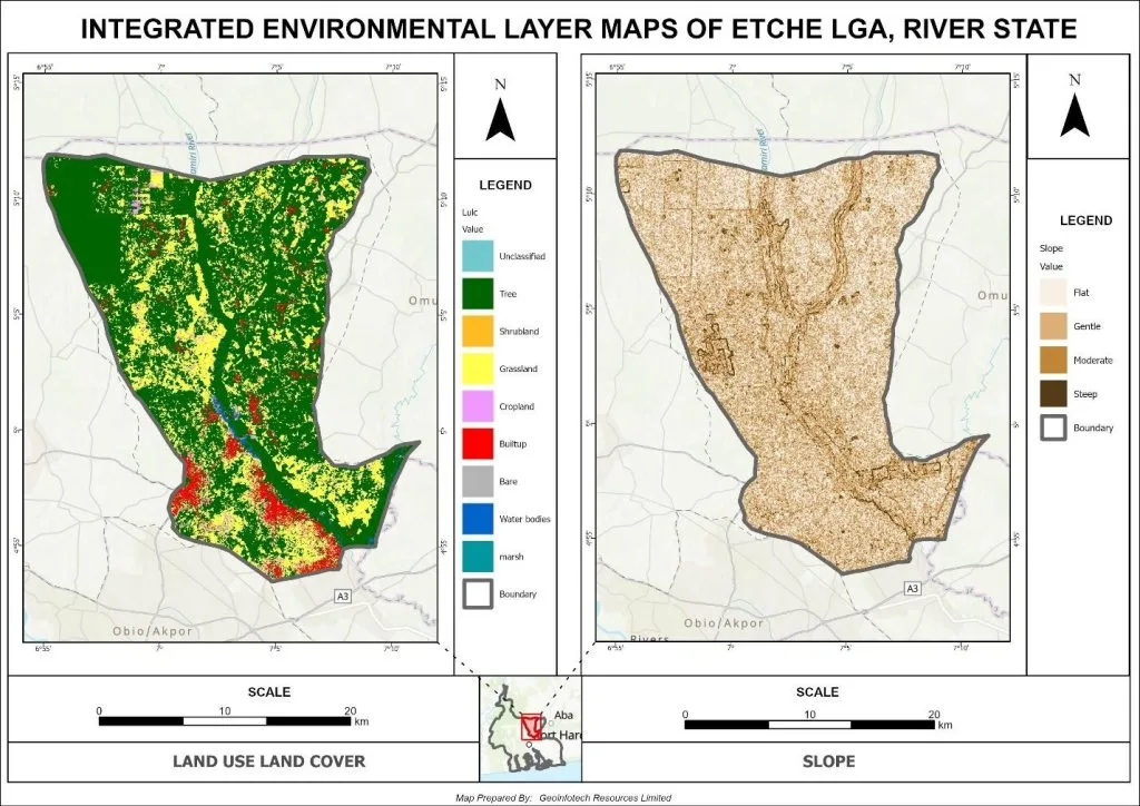
Figure 2: (a) Land use/land cover map and (b) Slope map
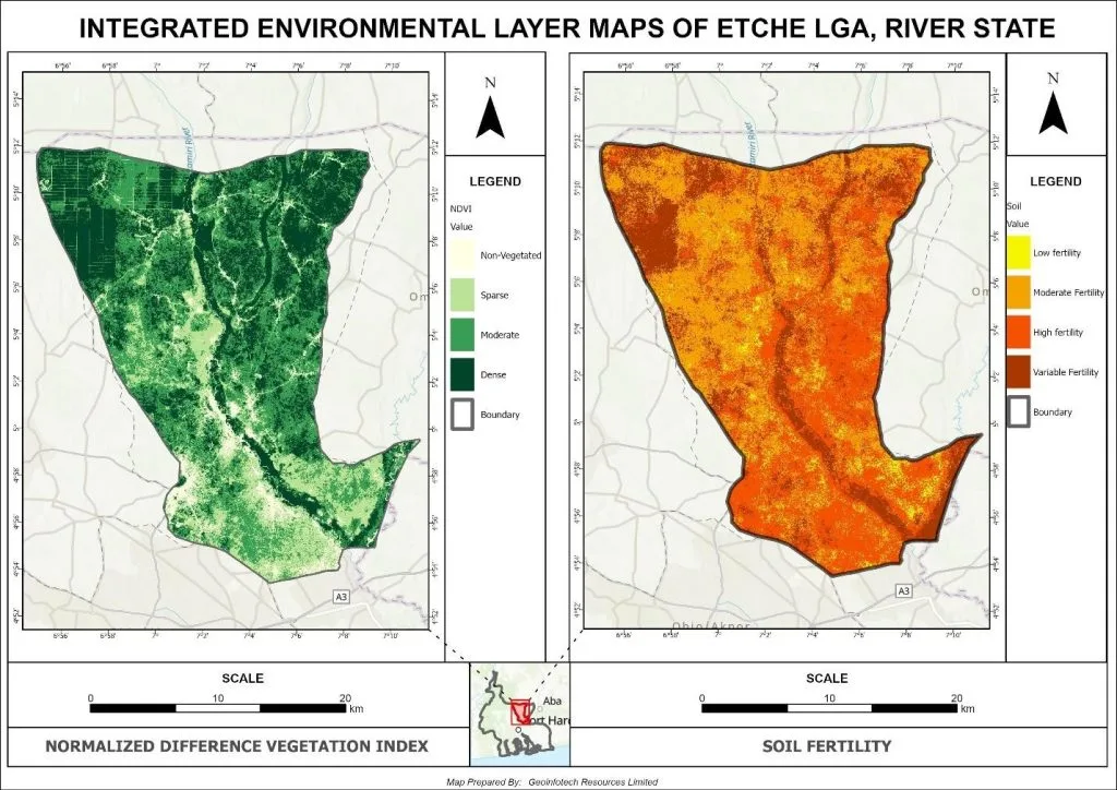
Figure 3: (a) NDVI map and (b) Soil suitability map
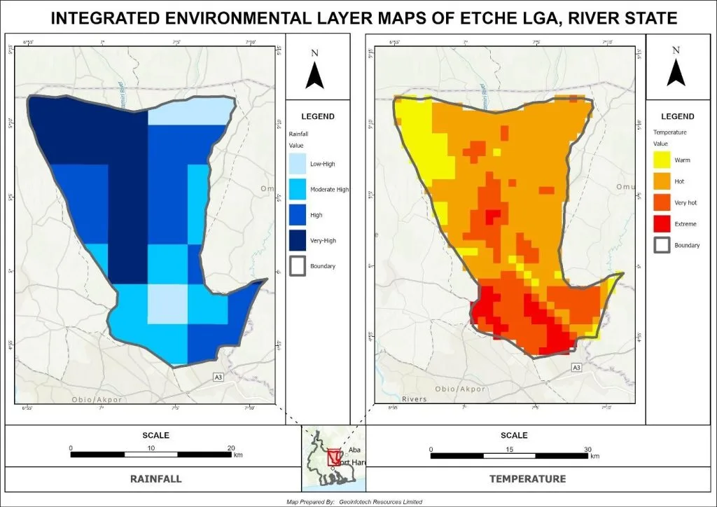
Figure 4: (a) Rainfall distribution map and (b) Temperature map
Figures 2,3 and 4. Environmental Factors Influencing Agricultural Suitability.
4.3 Standardization of Suitability Criteria
To ensure comparability across all environmental variables, each criterion was standardized to a common suitability scale ranging from Highly Suitable to Not Suitable for integration in the weighted overlay analysis.
For soil, three separate datasets: soil pH, soil texture, and soil organic carbon (SOC) were individually reclassified according to their agricultural suitability. These reclassified layers were then combined in ArcGIS using a weighted overlay tool to produce a composite Soil Suitability Map (Figure 3b). The relative importance of each soil component was determined through Analytical Hierarchy Process (AHP) pairwise comparisons, as detailed in Table 5.
Table 5a: Relative Importance of Soil Components (AHP-Derived Weights)
| Soil Component | Weight (%) | Weight (Decimal) |
| Soil pH | 53.900 | 0.539000 |
| Soil Texture | 29.700 | 0.297000 |
| Soil Organic Carbon | 16.400 | 0.164000 |
| Total | 100.000 | 1.000 |
Table 5b: Pairwise Comparison Matrix of Soil Components (AHP)
| Soil Component | Soil pH | Soil Texture | Soil Organic Carbon |
| Soil pH | 1 | 2 | 3 |
| Soil Texture | 1/2 | 1 | 2 |
| Soil Organic Carbon | 1/3 | 1/2 | 1 |
This was informed by established literature and adjusted until consistency was achieved, ensuring that the assigned weights reflect widely accepted relationships between soil properties and agricultural productivity ensuring that the composite layer reflects the proportional influence of each soil property on overall suitability.
The resulting composite soil layer was integrated with other standardized environmental criteria: slope, rainfall, NDVI, temperature, and land use/land cover to form the basis of the final multi-criteria evaluation (MCE). This approach maintains both the spatial integrity of soil properties and the technical rigor of weighting, ensuring that the agricultural suitability model accurately represents the combined influence of all relevant environmental factors.
The relative influence of each criterion in the multi-criteria evaluation is shown in the criteria contribution chart (Figure 5).
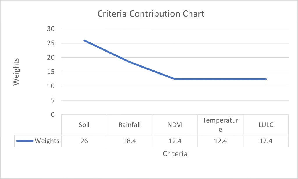
Figure 5. Criteria Contribution Chart.
Relative contribution of environmental criteria to the agricultural suitability model, highlighting the proportional influence of slope, rainfall, NDVI, temperature, composite soil, and land use/land cover.
Table 6. Criteria Weights Used in the Multi-Criteria Evaluation
| Criterion | Weight |
| Slope | 12.4% |
| Rainfall | 18.4% |
| NDVI | 18.4% |
| Temperature | 12.4% |
| Soil (PH, Texture, SOC) | 26% |
| Land Use/Land Cover | 12.4% |
4.4 Agricultural Suitability Index
The standardized layers were integrated using a weighted overlay (MCE) approach to produce a continuous agricultural suitability surface. Higher values indicate greater agricultural potential (Figures 6, 7 and 8).
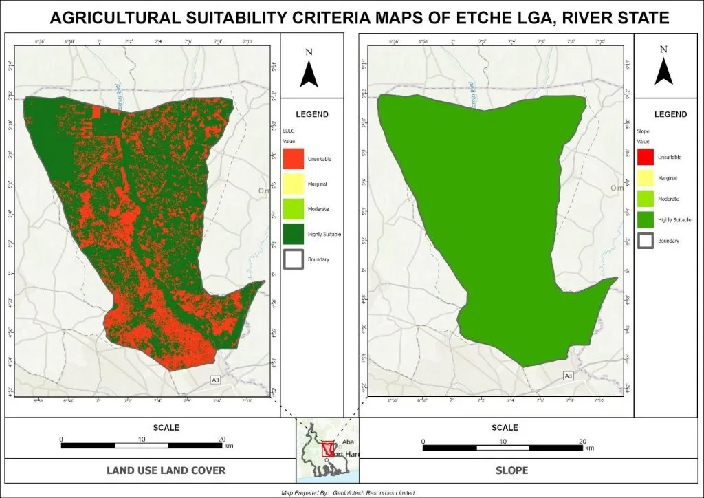
Figure 6. Agricultural Suitability Index Map showing (a) Land cover/Land use, and (b) Slope index
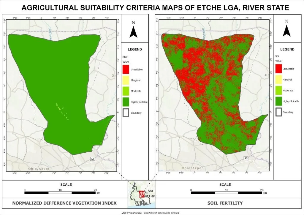
Figure 7. Agricultural Suitability Index Map showing (a) NDVI and (b) Soil index
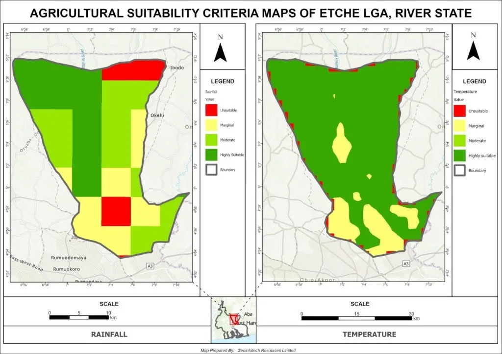
Figure 8. Agricultural Suitability Index Map showing (a) Rainfall and (b) Temperature index
Figures 6,7 and 8. Agricultural Suitability Index Map.
Continuous suitability surface was generated through weighted overlay analysis.
4.5 Final Agricultural Suitability Classification
The continuous suitability surface was classified into four categories: Highly Suitable, Moderately Suitable, Marginally Suitable, and Not Suitable. This classification facilitates interpretation for agricultural planning (Figure 9).
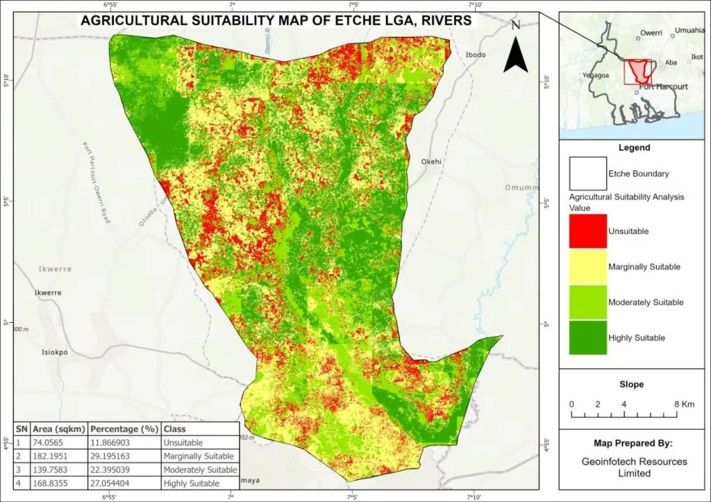
Figure 9. Final Agricultural Suitability Classification Map.
Spatial distribution of suitability classes across Etche LGA.
The proportion of land in each class is summarized in Figure 9 and Table 7.
Table 7. Agricultural Suitability Classification Statistics
| Suitability Class | Area (km²) | Percentage (%) |
| Highly Suitable | 168.8355 | 27.054404 |
| Moderately Suitable | 139.7583 | 22.395039 |
| Marginally Suitable | 182.1951 | 29.195163 |
| Not Suitable | 74.0565 | 11.866903 |
All input datasets were harmonized to a common spatial resolution (Table 8), ensuring consistency in the weighted overlay process and contributing to the reliability of the final suitability classification.
Table 8: Final Spatial Resolution Summary
| Dataset | Native Resolution | Final Analysis Resolution |
| Sentinel-2 | 10 m | 30 m |
| NDVI | 10 m | 30 m |
| Soil Texture | 30 m | 30 m |
| Soil Organic Carbon | 30 m | 30 m |
| Soil pH | 30 m | 30 m |
| WorldCover | 10 m | 30 m |
| DEM | 30 m | 30 m |
| Slope | 30 m | 30 m |
| MODIS LST | 1000 m | 30 m (resampled) |
4.6 GeoAI-Assisted Geospatial Data Processing and Input Feature Generation
To support the multi-criteria agricultural suitability modelling, a GeoAI-inspired geospatial workflow was implemented using Google Earth Engine (GEE) to efficiently derive, pre-process, and harmonize environmental datasets. Rather than serving as a predictive machine learning component, the framework was utilized to enhance data handling, automation, and large-scale spatial computation for the generation of model input variables.
Time-series satellite data and environmental variables were processed within GEE to derive key biophysical indicators required for the suitability analysis. These include vegetation health (NDVI), land surface temperature, rainfall and temperature aggregates, as well as land cover and topographic derivatives. The use of cloud-based geospatial computing ensured consistent temporal aggregation (2015–2024), spatial harmonization, and efficient pre-processing of multi-source datasets.
The derived datasets were standardized to a common spatial resolution and projection to ensure compatibility during integration within the GIS-based Analytical Hierarchy Process (AHP) weighted overlay model. This step was essential in reducing spatial inconsistency and ensuring that all input layers contributed uniformly to the final suitability assessment.
The GeoAI-enabled workflow significantly improved computational efficiency by automating repetitive geospatial processing tasks, including raster extraction, temporal averaging, and layer harmonization. This allowed for reproducible and scalable data preparation across the study area.
The outputs generated from the GeoAI-assisted processing stage served as direct input layers for the weighted overlay model and were subsequently integrated with soil, slope, and other environmental criteria for final suitability classification. The approach therefore supports the integration of intelligent geospatial processing with traditional multi-criteria evaluation methods, enhancing the robustness and efficiency of the overall modelling framework.
4.7 Sensitivity Analysis of the Suitability Model
Sensitivity analysis was performed to assess the stability, effectiveness and robustness of the agricultural suitability model under variations in the assigned AHP weights. The weights of soil parameters (soil pH, soil texture, and soil organic carbon) were systematically adjusted within a reasonable range to observe their influence on the spatial distribution of suitability classes.
The results as seen in (Figure 10) indicate that the overall spatial pattern of agricultural suitability remained largely stable despite minor modifications to input weights. High suitability zones consistently appeared in areas characterized by favourable soil conditions, while low suitability areas remained relatively unchanged. This demonstrates that the model outputs are not highly sensitive to small variations in the weighting scheme. Although slight shifts between suitability classes were observed in some zones, these changes did not significantly alter the overall classification pattern. This suggests that the model is robust and reliable for agricultural land evaluation within the study area.
The stability of the results further confirms that the integration of AHP-derived weights and GIS-based weighted overlay analysis provides a dependable framework for land suitability modelling. The consistency of outputs under different weighting scenarios enhances the credibility of the final suitability map presented in this study.
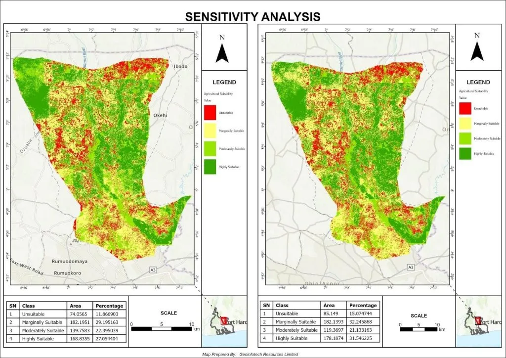
Figure 10. Sensitivity Analysis Map showing minimal changes in suitability classes.
CHAPTER FIVE
DISCUSSION
5.1 Influence of Environmental Criteria on Agricultural Suitability
The results of this study demonstrate that agricultural suitability in Etche LGA is controlled by the combined influence of multiple environmental variables rather than a single dominant factor. The integration of soil properties, climate conditions, vegetation characteristics, terrain, and land use/land cover produced a spatially heterogeneous suitability pattern across the study area. This confirms the strength of Multi-Criteria Decision Analysis (MCDA) in capturing complex environmental interactions that influence agricultural potential.
Areas exhibiting balanced environmental conditions generally correspond to higher suitability classes, while zones with limiting environmental factors show reduced agricultural potential. This highlights the necessity of integrated spatial modelling approaches for reliable land evaluation.
5.2 Role of Soil Properties in Agricultural Potential
Soil properties emerged as a critical determinant of agricultural suitability in the study area. Moderately fertile soils dominate the landscape, but spatial variations in soil pH, texture, and organic carbon significantly influence crop productivity. These parameters directly affect nutrient availability, water retention capacity, and soil structure.
The results indicate that areas with relatively better soil conditions consistently align with higher suitability zones. This reinforces the importance of soil as a foundational factor in agricultural land evaluation and supports its strong weighting in the MCDA framework.
5.3 Contribution of Climate and Vegetation Variables
Climate variables, particularly temperature and rainfall distribution, play a significant role in shaping agricultural suitability patterns. The generally high temperature conditions, combined with moderate rainfall, create a favourable but spatially variable agro-climatic environment.
Vegetation conditions, represented by sparse to moderately dense cover and NDVI-based indicators, further reflect differences in ecosystem productivity across the study area. Areas with higher vegetation vigour are strongly associated with improved agricultural suitability, confirming the interdependence between climate conditions and vegetation response.
5.4 Effect of Terrain (Slope) on Suitability Patterns
Terrain characteristics, particularly slope derived from Digital Elevation Model (DEM) analysis, influence the spatial distribution of agricultural suitability. The predominantly flat terrain of the study area generally favours agricultural activities by reducing erosion risk and supporting mechanized farming.
However, subtle variations in elevation and slope contribute to differences in drainage patterns and localized water accumulation, which in turn affect soil moisture conditions and suitability classification. This demonstrates that even gentle terrain variations can play a meaningful role in spatial suitability modelling.
5.5 Impact of Land Use/Land Cover
Land use and land cover (LULC) patterns significantly influence agricultural suitability outcomes. The study area is characterized by a mixture of grassland, scattered tree cover, and limited built-up areas. Sparse vegetation dominates most parts of the landscape, while denser vegetation occurs in localized zones.
Zones with less human disturbance and stable vegetation cover tend to exhibit higher suitability levels. In contrast, built-up and highly modified areas show reduced suitability. This highlights the role of LULC as both a physical constraint and an indicator of anthropogenic pressure on land resources.
5.6 Performance of the MCDA-AHP Model
The MCDA framework, supported by the Analytical Hierarchy Process (AHP), performed effectively in generating a structured and consistent weighting system for the selected criteria. The pairwise comparison process ensured that the relative importance of each factor was systematically evaluated, while the consistency ratio confirmed the logical reliability of the judgments.
The resulting weighted overlay model successfully translated environmental variables into a spatial suitability map, demonstrating the effectiveness of MCDA-AHP as a decision-support tool for agricultural land evaluation.
5.7 Contribution of GeoAI (Google Earth Engine Workflow)
The integration of Google Earth Engine (GEE) significantly enhanced the efficiency and scalability of geospatial data processing. It enabled the derivation of multi-temporal environmental variables such as NDVI and climate-related datasets over a multi-year period (2015–2024). This approach improved data consistency, reduced pre-processing time, and minimized errors associated with manual handling of large datasets.
The use of GEE demonstrates the potential of GeoAI-inspired workflows in modern geospatial modelling, particularly in data-limited environments.
5.8 Model Stability and Sensitivity Analysis
Sensitivity analysis indicates that the MCDA-AHP model is generally stable under minor variations in criterion weights. The overall stability of the model suggests that the suitability patterns are not excessively dependent on subjective weighting decisions. This enhances confidence in the robustness and reliability of the model for agricultural planning and decision-making purposes.
5.9 Comparison with Existing Studies
The findings of this study, unlike several conventional studies that rely basically on static datasets and limited validation approaches, introduces sensitivity analysis and a more structured MCDA-AHP framework. This enhances both the methodological robustness and practical applicability of the model, particularly in heterogeneous and data-limited environments.
CHAPTER SIX
CONCLUSION AND RECOMMENDATIONS
6.1 Conclusion
This study assessed agricultural land suitability using a multi-criteria decision analysis (MCDA) framework in combination with Analytical Hierarchy Process (AHP) and geospatial modelling techniques. By combining environmental, soil, climatic, terrain, and land use/land cover variables, the research provides a spatially explicit understanding of agricultural potential and constraints within the study area. The integration of geospatial analytics and decision-support modelling demonstrates the effectiveness of combining traditional spatial analysis with data-driven approaches for sustainable land-use planning.
6.2 Key Findings
The results indicate that soil properties exert the highest influence on agricultural suitability. Areas with favourable soil texture, moderate organic carbon content, and optimal pH values consistently showed higher suitability levels. Steeper slopes were associated with reduced suitability due to erosion risk and limited mechanization potential, while low-lying and gently sloping areas exhibited higher agricultural potential.
Land use/land cover patterns also significantly influenced suitability outcomes, with built-up areas and degraded lands showing limited agricultural potential compared to vegetated and grass lands. The MCDA-AHP model effectively classified the landscape into distinct suitability zones, demonstrating strong spatial consistency with known environmental conditions.
6.3 Policy Implications
The findings provide critical insights for land management and agricultural planning. The final suitability map can support policymakers in identifying priority zones for agricultural expansion in Etche LGA while safeguarding ecologically sensitive areas. Integrating the results gotten from this study into regional land-use planning can help minimize land degradation, reduce land-use conflicts, and promote more efficient allocation of agricultural resources. It also supports evidence-based decision-making for food security planning, particularly in regions in Rivers State, experiencing rapid urban expansion and environmental stress.
6.4 Recommendations
Based on the findings, it is recommended that:
- Agricultural expansion should prioritize areas identified as highly and moderately suitable.
- Unsuitable and marginal lands could be reserved for conservation or alternative land uses.
- Spatial decision-support tools such as MCDA-AHP should be integrated into routine land-use planning frameworks at local and regional levels.
- Continuous environmental monitoring should be adopted to track changes in land suitability over time.
6.5 Limitations of the Study
Despite the robustness of this approach, certain limitations were observed. The study relied on available secondary datasets, which may contain spatial or temporal inaccuracies. In addition, temporal variability of land cover was not fully captured, as the analysis was based on a static LCLU dataset.
6.6 Suggestions for Future Research
The integration of machine learning and advanced GeoAI models could further improve prediction accuracy and reduce subjectivity in weight assignment.
Additionally, future research could explore socio-economic variables such as accessibility, market proximity, zonal security and farming population distribution to develop a more holistic agricultural suitability model.
REFERENCES
Ahmed, J., and Kunda, J. J. (2013). Land Suitability Analysis for Agricultural Planning Using GIS and Multi-Criteria Decision Analysis Approach in Greater Karu Urban Area, Nasarawa State, Nigeria. African Journal of Agricultural Science and Technology 5(4), 81-91.
Akpoti, K., Kabo-bah, A. T., Zwart, S. J. (2019). Agricultural Land Suitability Analysis: State-Of-The-Art and Outlooks for Integration of Climate Change Analysis. Agricultural Systems 173, 172-208.
Chen, Y., Yu, J., and Khan, S. (2010). Spatial Sensitivity Analysis of Multi-Criteria Weights in GIS-Based Land Suitability Evaluation. Environ. Model. Softw. 25, 1582-1591.
Cityfacts : 2019-2026.
ElevaationMap.Net.
Gorelick, N., Hancher, M., Dixon, M., Ilyushchenko, S., Thau, D., and Moore, R. (2017). Google Earth Engine: Planetary-Scale Geospatial Analysis for Everyone. Remote Sensing of Environment 202, 18–27.
Ifeanyi-obi, C. C., Asiabaka, C.C., Adesope, O. M. and Issa F. O. (2011). Inhabitants Perception of Climate Change, Effects and Adaptation Strategies in Etche Local Government Area of Rivers State, Nigeria. Global Journal of Applied Agricultural Research 1 (1), 57-64.
Joshi, V., Singh, S. (2024). A GIS and MCDA Framework for Land Suitability Analysis in Sustainable Agriculture. International Journal of Land 01(02), 30-34.
Joshua, J. K., Anyanwu, N. C., and Ahmed, A. J. (2013). Land Suitability Analysis for Agricultural Planning Using GIS and Multi Criteria Decision Analysis Approach in Greater Karu Urban Area, Nasarawa State, Nigeria. Afr. J. Agric. Sci. Technol 1(1), 14-23.
Ramankutty, N., Foley, J. A., Norman, J., and McSweeney, K. (2002). The Global Distribution of Cultivable Lands: Current Patterns and Sensitivity to Possible Climate Change. Global Ecology and Biogeography, 11(5), 377-392.
Saaty, T. L. (1980). The Analytic Hierarchy Process. Mcgraw-Hill.
Saaty, T. And Vargas, L. G. (2022). Models, Methods, Concepts and Application of the Analytic Hierarchy Process. International Series in Operations Research & Management Science 175, 149-158.
Singh, A. K., And Patra, A. K. (2025). Pathways for Sustainable Development and Multi-Criteria Decision-Making Using AI and GIS. In Artificial Intelligence, Geographic Information Systems, And Multi-Criteria Decision-Making for Improving Sustainable Development. Auerbach Publications 1-17.
Tucker, C. J. (1979). Red and Photographic Infrared Linear Combinations for Monitoring Vegetations. Remote Sensing of Environment 8(2), 127-150.
Ujoh, F., Igbawua, T., And Paul, M. (2019). Suitability Mapping for Rice Cultivation in Benue State, Nigeria Using Satellite Data. Geo-Spatial Information Science 22, 332 – 344.
Vijayakumar, S., Saravanakumar, R., Arulanandam, M., And Ilakkiya, S. (2024). Google Earth Engine: Empowering Developing Countries with Large-Scale Geospatial Data Analysis—A Comprehensive Review. Arabian Journal of Geosciences, 17(4), 139.
Wang, S., Huang, X., Liu, P., Zhang, M., Biljecki, F., Hu, T., Fu, X., Liu, L., Liu, X., Wang, R., Huang, Y., Yan, J., Jiang, J., Chukwu, M., Naghedi, S., Hemmati, M., Shao, Y., Jia, N., Xiao, Z., Tian, T., Hu, Y., Yu, L., Yap, W., Macatulad, E., Chen, Z., Cui, Y., Ito, K., Ye, M., Fan, Z., Lei, B., & Bao, S. (2024). Mapping The Landscape and Roadmap Of Geospatial Artificial Intelligence (Geoai) In Quantitative Human Geography: An Extensive Systematic Review. Int. J. Appl. Earth Obs. Geoinformation, 128, 103734.
Wijesinghe, D. (2024). GIS-Based AHP and MCDA Modeling for Cropland Suitability Analysis: A Bibliometric Analysis. Gazi University Journal of Science Part A Engineering And Innovation 11, 598-621.
Wijesinghe, M. D. (2024). Residential Site Suitability Modelling Using GIS with Integrated Analytical Hierarchy Process in Galle Municipal Council. Annals of The National Association of Geographers, India 44(1), 117.
Yu, J., Shahbaz, K., And Xevi, E. (2009). A GIS-Based Sensitivity Analysis of Multi-Criteria Weights.
Zabel, F., Putzenlechner, B., and Mauser, W. (2014). Global Agricultural Land Resources – A High Resolution Suitability Evaluation and Its Perspectives Until 2100 Under Climate Change Conditions. PloS One, 9(9), e107522.
Zhu, X. (2016). GIS for Environmental Applications: A Practical Approach. Routledge 1, 30-490