REPORT ON
DRONE MAPPING & VECTORIZATION OF
ABU-ALLIED FARM
LOCATED AT
KEFFI LOCAL GOVERNMENT AREA NASSARAWASTATE
1.0 Introduction
Geoinfotech Resources Limited was awarded and to execute Drone Mapping/Survey of Abu-Allied Farm located at Keffi Local Government Area of Nassarawa State. The project was carried out between 18th July 2022 with mobilization and was concluded on the 08th August 2022 with the submission of all deliverables and technical reports. This report describes in detail the works carried out.
1.1 Project Specifications
The scope of work for this project is as follows:
∙ Reconnaissance Survey for Ground Control Points
∙ Establishment of Ground Controls
∙ Data Computation and Error Validation
∙ Drone Mapping for Data Capture
∙ Drone Deployment for Videography and Photography & Processing ∙ Drone Data Processing with Pix4DMapper Software for Orthophotos ∙ Production of 3D Map & Digital Elevation Models
∙ Vectorization/Digitization for Property Plot Delineation (Attributes, Id, Coordinates, Perimeter, and Area)
∙ Deliverables (Softcopy of Orthophotos, Drawing, JPEG, GeoTIFF, and PDF) ∙ Report being presented using MS Office Suite
2.0 Project Personnel and Equipment
2.1 Personnel:
The following personnel made up the project team that carried out the project
| Personnel Designation | Responsibility | Name |
| Project Coordinator (Drone Pilot) | Management and Coordination | Surv. Ani Etuk |
| Surveyor | Data Acquisition and GCP Establishment with Tersus GNSS Receiver | Surv. Ani Etuk |
| Assistant Pilot | Drone Deployment for Mapping | Olugbenga Ebenezer B. |
| Lab Analysts | Drone Data Processing, Digitization Result Presentation | Surv. Ani Etuk, Olugbenga Ebenezer B. & Makinde Temitope |


2.2 Equipment:
The following equipment was used in the execution of the project.
2.3 Data Acquisition:
– Unmanned Aircraft Systems
– A Tersus GNSS Receiver and its accessories
– White spray paints for GCPs marking
– 5m and 50m steel measuring tapes
2.4 Data Processing Software & Result Presentation:
– A Digital Mapping Workstation
– Pix4DMapper Software
– ArcGIS Pro Software
– MS Office Suite
2.5 Logistics
All personnel were issued standard Personnel Protective Equipment (PPE)
3.0 Methodology
3.1 Project Strategy
The project was carried out in two phases namely,
Field Work
Office Work
3.2 Field Work Phase
The works carried out under the Field Work Phase are
– Mobilization
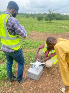
– Reconnaissance: Site inspection was carried out to get an overview of the extent and to take into cognizance of the existing features within the study site for proper planning for seamless data acquisition.
– Establishment of GCPs: Ground Control Points were established using spray paints.
– GCPs Data Acquisition: The instrument was operated in 3Dimensional mode i.e. Easting, Northing, and Heights coordinates were acquired in order to use these points for Georectification.
– Unmanned Aerial Vehicles were deployed for mapping of the entire estate, and different missions (flight plans) were created for effective aerial mapping.
– UAVs were deployed to also capture imageries (photos) of the entire ABU-ALLIED Farm
3.3 Office Work Phase
The works carried out under the Office Work Phase are:
– Data Cataloguing: Acquired field data for the GCPs was downloaded from the GNSS receiver.
– The captured images, photographs, and videos were also downloaded from the UAV devices.
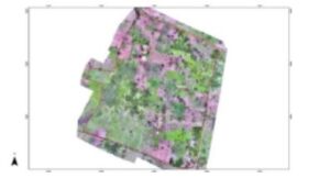
– Data processing and Analysis: The imageries were processed using Drone Imagery Processing Software (Pix4DMapper).
∙ The Imageries & Ground Control Point Coordinates were loaded into the Pix4DMapper software
∙ The Imagery was aligned and georectified
∙ Dense cloud, Mesh, Texture, and Tiled Models, were all built in the
Pix4DMapper environment.
∙ Digital Elevation Model was built and finally Orthomosaic and Orthophotos were built.
∙ The DEM and Orthophotos were exported as (GeoTIFF)


∙ The DEM was used to produce contour analysis in ArcGIS Pro Software ∙ The generated Orthophoto was imported into ArcGIS Pro for extraction (digitization/vectorization) of land parcels and a total number of 2 parcels were digitized, ID, Perimeter, and Area in hectares were calculated for each of the farm parcels.
∙ Cartographic embellishment was carried out for the digitized plots and hence the map is ready for presentation.
∙ The map was presented to some members of the project committee (Clients) for vetting and corrections.

– Data Presentation: the various layers were combined and due corrections were made after thorough checks. The result was then presented in softcopy and hardcopy
– Reporting
– Printing of produced layers of maps
– Submission of Deliverables
4.0 Deliverables
The deliverables for the project are both in hardcopy and softcopy and are as stated in the table below:
| Type | Description |
| Spatial Data | 3D data of all acquired points on-site in MS Excel file format, DEM & Orthophotos |
| Plan Production in Softcopy | Map showing Details & Topographical Survey, Land Parcels in PDF format |
| Hardcopy Printing | Hardcopies in A3 paper size |
| Report | PDF and Word format |
5.0 Conclusions
The Drone Mapping and Digitization were completed and on careful analysis of the data acquired, the results of the data processing, and the plans produced, we safely came to the following conclusions:
The maps produced as a result of the drone mapping and digitization are a true and realistic representation of the subject site at the time the survey was carried out. The mapping was carried out in full accordance with existing specifications, survey laws, and regulations and in compliance with our company’s Quality Control.


