 Multispectral Drone Mapping in Nigeria.
Agricultural fields are rarely uniform. Even within the same farm, some areas may have stronger crop growth, while others may experience water stress, nutrient problems, poor establishment or other forms of stress.
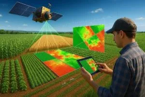
Multispectral drone mapping in Nigeria provides a way to identify these differences at very high spatial resolution. Instead of relying only on normal aerial photographs, multispectral drones capture information from several wavelengths of light. That information can then be processed into vegetation-index maps for crop monitoring and precision agriculture.
What Is Multispectral Drone Mapping?
Multispectral drone mapping involves using a drone equipped with a multispectral camera to capture images in specific spectral bands.
Common bands include green, red, red-edge and near-infrared. Plants reflect and absorb these wavelengths differently, depending on their structure, chlorophyll content and condition.
The resulting imagery can be processed into an orthomosaic and several vegetation indices. Geoinfotech’s multispectral drone workflow, for example, supports blue, green, red, red-edge and near-infrared imagery and produces indices including NDVI, GNDVI, NDRE and OSAVI.
Why Use Multispectral Drones for Agriculture in Nigeria?
Traditional field scouting remains important, but manually inspecting every part of a large farm can be time-consuming.
A drone can capture detailed imagery across an entire field and reveal areas that require closer investigation. This is particularly useful for crop monitoring, identifying variability and comparing field conditions over time.
Research in Nigeria has already demonstrated the use of UAV multispectral imagery for maize production, with NDVI, NDRE and GNDVI used alongside field measurements to investigate yield variability.
More recent research in Southwest Nigeria has also explored low-cost drone-based multispectral imaging for crop-health monitoring on smallholder farms in Oyo and Ogun States.
NDVI: General Crop Vigour and Vegetation Monitoring
The Normalized Difference Vegetation Index (NDVI) is probably the most widely recognised vegetation index in remote sensing.
It uses red and near-infrared reflectance:
NDVI = (NIR − Red) / (NIR + Red)
Healthy vegetation generally absorbs red light for photosynthesis while reflecting relatively large amounts of near-infrared radiation. This produces stronger NDVI responses than bare soil or sparse vegetation.
NDVI is useful for examining general vegetation vigour, crop development and spatial variability. However, it can become less sensitive in dense, mature canopies because of saturation.
NDRE: Looking at Chlorophyll and Dense Canopies
The Normalized Difference Red Edge Index (NDRE) replaces the red band with a red-edge band:
NDRE = (NIR − Red Edge) / (NIR + Red Edge)
The red-edge portion of the spectrum is particularly useful for detecting changes associated with chlorophyll and vegetation condition.
NDRE can therefore be useful during mid-to-late crop development, when NDVI may become less sensitive to differences within dense vegetation.
GNDVI: Using the Green Band
The Green Normalized Difference Vegetation Index (GNDVI) uses green and near-infrared reflectance:
GNDVI = (NIR − Green) / (NIR + Green)
Because it uses the green band instead of red, GNDVI can provide another perspective on vegetation condition and chlorophyll-related variation.
This makes it useful when comparing different vegetation responses across a field. However, GNDVI should not be interpreted as a direct measurement of nitrogen or plant health. Its meaning depends on the crop, growth stage, sensor and field conditions.
OSAVI: Reducing Soil Background Effects
The Optimized Soil-Adjusted Vegetation Index (OSAVI) is particularly useful when vegetation cover is relatively sparse.
One challenge during early crop development is that bare soil can influence the spectral signal captured by the sensor. OSAVI introduces a soil-adjustment factor to reduce some of this influence.
This can make it useful for early-season crop assessment, emergence monitoring and fields where vegetation does not yet form a dense canopy.
Which Vegetation Index Should You Use?
There is no single index that is automatically the best for every agricultural application.
- NDVI: Useful for general crop vigour, biomass and vegetation variability.
- NDRE: Useful for dense canopies and analysing chlorophyll-related variation.
- GNDVI: Provides additional information about vegetation condition using the green band.
- OSAVI: Useful where exposed soil can influence vegetation measurements, especially during early growth.
The choice should depend on the crop, growth stage, sensor bands and purpose of the survey. Using several indices together can provide a more complete picture than relying on one map alone.
How Crop Health Analysis Works
A typical multispectral drone workflow begins with flight planning and image acquisition. The drone then captures overlapping multispectral photographs across the farm.
After processing, the images can produce a high-resolution orthomosaic and vegetation-index maps. Areas with unusual spectral responses can then be identified for further investigation.
The important point is that an index map does not automatically diagnose the cause of crop stress. Water shortage, nutrient deficiency, disease, pests, soil variation and other factors can produce similar spectral patterns. Therefore, drone analysis should guide field scouting and agronomic assessment rather than replace it.
From Multispectral Maps to Farm Decisions
The real value of multispectral drone mapping comes when the information supports a practical decision.
For example, farmers can use repeated surveys to monitor crop development, identify areas requiring field inspection and compare conditions between different parts of a farm. The resulting information can also support prescription maps and variable-rate applications where the appropriate equipment and agronomic workflow are available.
Geoinfotech provides multispectral drone processing for NDVI, GNDVI, NDRE and OSAVI, alongside prescription-map generation for agricultural applications.
As drone technology becomes more accessible, multispectral drone mapping in Nigeria can give farmers and agribusinesses a more detailed view of crop variability. Combined with field observations, GIS and agronomic knowledge, these maps can turn aerial imagery into practical information for more targeted crop management.