

How can a single satellite image help prevent flooding, improve crop production, or guide the construction of new infrastructure? Every day, vast amounts of data are collected from satellites, drones, and aerial sensors. However, the real value of remote sensing lies not in collecting the data, but in applying it to solve real-world challenges.
Across Nigeria, applied remote sensing is helping governments, businesses, and organizations make smarter, faster, and more informed decisions.
What Is Applied Remote Sensing?
Applied remote sensing is the practical use of satellite imagery, drone data, and aerial photographs to analyze the Earth’s surface and solve specific problems. Instead of simply observing landscapes, professionals use remote sensing data to monitor changes, identify risks, and support planning across different sectors.
When combined with Geographic Information Systems (GIS), remote sensing transforms raw imagery into meaningful insights that drive decision-making.
How Remote Sensing Supports Real-World Decisions
Remote sensing provides up-to-date information that helps organizations understand what is happening on the ground without physically visiting every location.
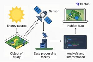
The process typically involves:
- Collecting imagery using satellites, drones, or aircraft
- Processing and enhancing the data
- Analyzing patterns and changes using GIS software
- Producing maps and reports that support informed decision-making
This approach saves time, reduces costs, and provides accurate information over large geographic areas.
Real-World Applications of Remote Sensing
Agriculture
Remote sensing enables farmers to monitor crop health, detect pest infestations, identify nutrient deficiencies, and assess water stress before problems become severe.
These insights support precision agriculture, helping farmers increase productivity while reducing unnecessary use of fertilizers, pesticides, and water.
Environmental Monitoring
Environmental agencies use remote sensing to monitor deforestation, desertification, wetland degradation, shoreline erosion, and climate-related changes.
Continuous monitoring allows authorities to detect environmental changes early and implement appropriate conservation measures.
Disaster Risk Management
Remote sensing plays a critical role in preparing for and responding to natural disasters.
It helps organizations:
- Monitor flood-prone areas
- Assess erosion risks
- Map wildfire impacts
- Identify communities at risk
- Support emergency response planning
Timely spatial information enables faster and more effective disaster management.
Urban and Regional Planning
As Nigerian cities continue to expand, planners rely on remote sensing to monitor urban growth, analyze land use changes, and identify suitable locations for new infrastructure.
These insights support sustainable development and better land management.
Mining and Mineral Exploration
Remote sensing assists geologists in identifying potential mineral-rich areas, mapping geological structures, and monitoring mining activities.
By reducing the need for extensive field surveys, it lowers exploration costs and improves efficiency.
Infrastructure Development
Before roads, bridges, pipelines, or buildings are constructed, remote sensing provides valuable information about terrain, land cover, drainage patterns, and environmental conditions.
This helps engineers and planners make informed decisions throughout the project lifecycle.
Why Applied Remote Sensing Matters
Applied remote sensing offers several advantages across industries:
- Faster access to reliable information
- Large-area coverage within a short period
- Reduced field survey costs
- Improved planning and project management
- Early detection of environmental and infrastructure risks
- Better resource allocation
- Data-driven decision-making
These benefits make remote sensing an essential tool for sustainable development and national planning.
The Role of GIS in Applied Remote Sensing
Remote sensing and GIS work together to unlock the full value of spatial data. While remote sensing captures information about the Earth’s surface, GIS organizes, analyzes, and visualizes that information.
This integration enables professionals to create thematic maps, monitor environmental changes, perform suitability analyses, and develop interactive visualizations that support strategic planning.
How Geoinfotech Helps Organizations Turn Data into Decisions
Geoinfotech combines remote sensing, GIS, drone technology, and spatial analytics to help clients transform geospatial data into practical solutions. Our expertise supports projects in agriculture, environmental management, urban planning, mining, infrastructure development, disaster risk management, and natural resource management.
Our services include:
- Satellite image analysis
- Land use and land cover mapping
- Change detection analysis
- Flood and erosion assessment
- Mineral exploration support
- Drone mapping and aerial surveys
- GIS-based spatial analysis and visualization
- Environmental monitoring and reporting
By turning complex geospatial data into actionable insights, we help organizations make informed decisions with confidence.
Final Takeaway
Applied remote sensing is more than just collecting satellite images—it is about transforming data into knowledge and knowledge into action. From improving agricultural productivity and monitoring environmental changes to supporting infrastructure projects and disaster response, remote sensing is shaping smarter decisions across Nigeria.
As technology continues to evolve, organizations that embrace applied remote sensing will be better equipped to solve complex challenges, optimize resources, and plan for a more sustainable future. With the right expertise and geospatial tools, data becomes a powerful asset for real-world decision-making.















































































