



How to Attend a Geospatial Summit in Nigeria: A Step-by-Step Guide for 2026
Are you interested in attending a geospatial summit in Nigeria but unsure where to start? Whether you are a GIS professional, student, drone operator, researcher, business owner or technology enthusiast, attending a geospatial event can be an excellent opportunity to learn, connect and discover emerging technologies.
Geospatial summits bring together people and organizations working with Geographic Information Systems (GIS), remote sensing, drone technology, surveying, mapping and geospatial intelligence.
However, attending one involves more than simply choosing an event. You also need to understand the registration process, confirm event details, prepare for sessions and plan your participation.
If you are considering a geospatial event in Nigeria in 2026, this guide explains the process step by step, using Geoinnovation Summit 3.0 in Lagos as an example.
1. Find a Geospatial Summit That Matches Your Interests
First, identify a summit that aligns with your professional interests, studies or business objectives.
Geospatial technology covers several fields. Therefore, not every event focuses on the same subjects.
While some summits concentrate on GIS and remote sensing, others explore drone technology, surveying, artificial intelligence, geospatial intelligence, infrastructure monitoring and national security.
Before making a choice, consider:
- The event’s theme and areas of focus.
- The professionals and organizations expected to attend.
- Advertised technical sessions and masterclasses.
- Networking and collaboration opportunities.
- Product exhibitions and technology demonstrations.
- Event dates, location and registration requirements.
Ultimately, choosing an event that matches your interests helps you get more value from your attendance.
2. Visit the Official Event Website
Once you identify a suitable summit, visit its official website.
This step is important because event websites provide essential information about registration, ticket categories, dates, venues and scheduled activities.
For example, the official website for Geoinnovation Summit 3.0 is:
https://geoinnovation.geoinfotech.ng/
Take time to review the available information before proceeding. In particular, check the registration instructions and updates from the organizers.
You can also look out for announcements about speakers, exhibitors, program activities and other event developments.
3. Choose Your Ticket or Registration Package
Depending on the event, organizers may offer different registration packages with varying levels of access.
For instance, some summits provide general admission, standard attendance or executive packages. Each option may include different benefits.
Before selecting a package, check:
- What activities does it include?
- Does it provide access to the main stage?
- Are exhibition areas included?
- Does it cover masterclasses or technical sessions?
- Are certificates or additional networking opportunities included?
- What are the ticket price and payment requirements?
Most importantly, do not assume every package offers identical benefits. Read the official descriptions carefully before making payment.
For Geoinnovation Summit 3.0, visit the official registration channels to check current package options, prices and availability.
4. Complete Your Registration
After choosing your preferred package, follow the registration instructions provided by the organizers.
Depending on the registration platform, you may need to submit your name, email address, phone number and professional or organizational details.
Where payment is required, use only the payment method specified through the official registration process.
Once registration is complete:
- Confirm that your registration was successful.
- Check your email for a confirmation message.
- Save your ticket or registration confirmation.
- Review any instructions provided to attendees.
- Contact the organisers if you encounter problems.
For the latest registration information, use the official GeoInnovation Summit website.
5. Plan Your Travel and Accommodation
If you are travelling from outside the event city, arrange your journey early.
This is particularly important for a two-day summit because accommodation may be necessary, depending on your travel arrangements.
Consider the following:
Transportation: Identify how you will reach the venue. Also, compare available transport options and estimate your journey time.
Accommodation: If you are travelling from another state, consider booking somewhere convenient before departure.
Event location: Confirm the venue address and identify nearby landmarks.
Budget: Set aside money for transportation, accommodation, meals and other personal expenses.
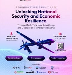
Geoinnovation Summit 3.0 will hold at High Point Event Centre, Agidingbi, Ikeja, Lagos, Nigeria.
Therefore, attendees travelling from other parts of the country should plan their journeys around the two-day event.
6. Prepare Before Attending the Summit
Proper preparation can make a significant difference to your experience.
Before the event, review the program and identify sessions that interest you most.
For example, GIS professionals may want to focus on geospatial intelligence, spatial analysis and GeoAI. Meanwhile, drone operators may prefer UAV surveillance, drone demonstrations and related technologies.
Business owners, on the other hand, may find the exhibition more useful for meeting technology providers and identifying potential partners.
Additionally, prepare the following:
- Questions for speakers and exhibitors.
- Business cards or professional contact details.
- A notebook or device for taking notes.
- Your ticket or registration confirmation.
- A list of people or organizations you hope to meet.
Having clear objectives will help you use your time more effectively.
7. Attend the Sessions, Exhibitions and Networking Activities
Once you arrive, make the most of the opportunities available.
Rather than limiting your participation to presentations, explore the exhibition areas, engage with other attendees and ask relevant questions.
At Geoinnovation Summit 3.0, the advertised activities include:
Main-stage sessions: Keynotes, panel discussions and technical sessions involving professionals from defense, government, engineering and industry.
Masterclasses: Practical learning opportunities, including a dedicated GeoAI track.
Product launches and demonstrations: Opportunities to explore surveillance, mapping and GeoAI solutions.
Exhibition expo: A platform for discovering products, hardware and services from exhibitors and partners.
Drone Arena: Activities including the Drone Speed and Precision Challenge, Geoinnovation GIS Challenge and Inter-Institutional GIS Challenge.
Business networking: A Business Connection Zone, B2B meetings and networking reception.
Together, these activities offer different ways to learn, explore technology and connect with professionals across the industry.
8. Network With Other Participants
Beyond attending presentations, one of the most valuable parts of a geospatial summit is meeting people with different professional backgrounds.
You may connect with GIS analysts, surveyors, drone operators, engineers, researchers, government representatives, business owners and technology developers.
Use these opportunities to introduce yourself, discuss your interests and exchange ideas.
Furthermore, speak with exhibitors about their products and services. You can also explore possible collaborations and learn how other organizations apply geospatial technology.
After the event, follow up with useful contacts through appropriate professional channels.
Remember, networking is not simply about collecting phone numbers. Instead, it involves building relationships that can create value beyond the summit.
9. Apply What You Learn After the Event
The benefits of attending a geospatial summit should continue even after the event ends.
Start by reviewing your notes, researching interesting technologies and identifying practical ways to apply your new knowledge.
For students, this could involve exploring a research area or developing a GIS project.
Similarly, professionals may use what they learn to improve existing workflows or develop new technical skills.
Business owners, meanwhile, could evaluate emerging technologies, contact potential partners or explore new service opportunities.
Ultimately, applying the knowledge and relationships gained will make the experience more valuable.
Attend Geoinnovation Summit 3.0 in Nigeria
If you are planning to attend a geospatial summit in Nigeria, Geoinnovation Summit 3.0 is an upcoming event worth considering.
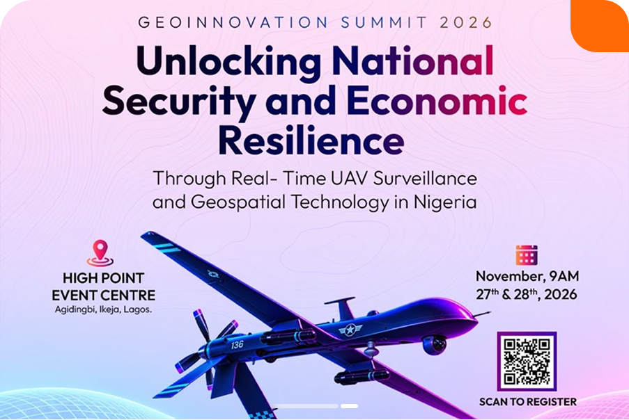
Organized by Geoinfotech, the summit will take place on November 27th–28th, 2026, at High Point Event Centre, Agidingbi, Ikeja, Lagos.
Its theme is:
“Unlocking National Security and Economic Resilience Through Real-Time UAV Surveillance and Geospatial Technology in Nigeria.”
The event will bring together industry leaders, technology experts, innovators, researchers and decision-makers. Together, they will explore how geospatial technology and real-time UAV surveillance can contribute to national security and economic resilience.
The summit is relevant to:
- GIS and remote-sensing professionals.
- Surveyors and mapping specialists.
- Drone pilots and UAV operators.
- Engineers and technology developers.
- Government and security professionals.
- Business owners and entrepreneurs.
- Students and researchers.
- Individuals interested in emerging technologies.
With masterclasses, technical sessions, product showcases, exhibitions, drone activities and networking opportunities, attendees can explore different aspects of Nigeria’s geospatial technology ecosystem.
Frequently Asked Questions
Do I need to be a GIS professional to attend a geospatial summit?
No. Many geospatial events welcome students, researchers, business owners, technology enthusiasts and professionals from related industries. However, check the event’s audience and program to ensure they match your interests.
How do I register for a geospatial summit in Nigeria?
Visit the official event website, review the available registration options and select a suitable package. Afterwards, follow the organizers’ registration and payment instructions.
Where will Geoinnovation Summit 3.0 take place?
The summit will take place at High Point Event Centre, Agidingbi, Ikeja, Lagos, Nigeria.
When is Geoinnovation Summit 3.0?
The event is scheduled for November 27th–28th, 2026.
What should I bring to a geospatial summit?
Bring your registration confirmation, a notebook or device for taking notes and your professional contact details. Additionally, prepare any materials you may need for networking or participating in activities.
Can students attend a geospatial summit?
Yes, provided the event welcomes student participation. Such events can help students gain industry exposure, explore emerging technologies and connect with experienced professionals.
Final Thoughts
Attending a geospatial summit in Nigeria can be a valuable step towards expanding your knowledge, developing professional relationships and discovering emerging technologies.
The process is straightforward: identify a relevant event, visit its official website, review the registration options, complete your registration and plan your participation.
If you are interested in GIS, remote sensing, UAV surveillance, GeoAI or geospatial intelligence, consider attending Geoinnovation Summit 3.0.
Join the conversation on November 27th–28th, 2026, at High Point Event Centre, Ikeja, Lagos.
Visit https://geoinnovation.geoinfotech.ng/ for event information, registration instructions and current ticket availability.