Accurate measurements are essential when planning roads, buildings, drainage systems, utility networks, and other infrastructure. Traditional surveying methods remain valuable, but modern technologies now allow professionals to collect large amounts of spatial information much faster.
One of these technologies is LiDAR, which stands for Light Detection and Ranging. LiDAR uses laser pulses to measure distances between a sensor and objects on the Earth’s surface. The resulting data can produce highly detailed three-dimensional representations of terrain, buildings, vegetation, and infrastructure.
Because of this capability, the applications of LiDAR in remote sensing continue to expand across land surveying, construction, engineering, urban planning, and infrastructure management.
What Is LiDAR in Remote Sensing?
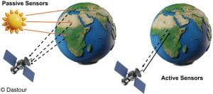
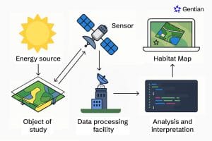
LiDAR is an active remote sensing technology. Unlike passive optical sensors, it generates its own energy rather than relying on sunlight.
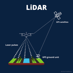
The sensor sends thousands or even millions of laser pulses toward the ground and surrounding objects. When these pulses return to the sensor, the system measures the time they took to travel.
Using this information, professionals can calculate distances and generate 3D point clouds.
LiDAR systems can operate from different platforms, including aircraft, drones, vehicles, and ground-based equipment. Therefore, surveyors can select a system based on the size and requirements of their project.
How Does LiDAR Surveying Work?
A typical LiDAR survey follows a relatively simple process.
First, the LiDAR sensor sends laser pulses toward the survey area. Next, surfaces such as buildings, roads, trees, and the ground reflect some of those pulses back to the sensor.
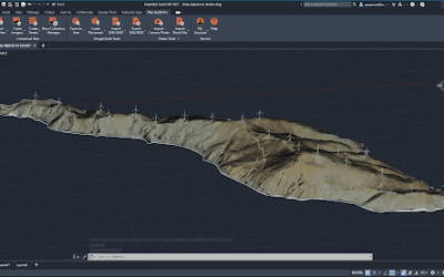
The system records the return time and position of each measurement. After processing, these measurements form a dense point cloud representing the surveyed environment.
Surveyors can then classify the points and create products such as:
- Digital Elevation Models (DEMs)
- Digital Surface Models (DSMs)
- Contour maps
- 3D terrain models
- Infrastructure models
As a result, LiDAR provides both detailed measurements and a powerful visual representation of the survey area.
Major Applications of LiDAR in Remote Sensing
The applications of LiDAR in remote sensing cover many aspects of land and infrastructure surveying.
1. Topographic and Land Surveys
LiDAR can capture detailed information about ground elevation across large areas. This makes it particularly useful for topographic surveys.
Surveyors can use LiDAR data to identify slopes, valleys, ridges, drainage patterns, and changes in terrain. Furthermore, the resulting elevation models can support engineering design and site planning.
For large construction sites or extensive development areas, airborne or drone-based LiDAR can collect terrain information efficiently.
2. Road and Highway Surveys
Road projects require accurate information about terrain, existing roads, drainage, and surrounding infrastructure.
LiDAR can capture these features while also providing detailed elevation information. Consequently, engineers can use the data for road alignment, corridor mapping, earthwork calculations, and drainage planning.
Mobile LiDAR systems can also collect data while moving along roads, making them useful for surveying long transportation corridors.
3. Infrastructure Inspection
LiDAR can capture detailed 3D information about existing infrastructure.
For example, professionals can use LiDAR to survey bridges, buildings, towers, power lines, and other structures. The resulting point clouds can reveal dimensions, structural geometry, and spatial relationships.
In addition, repeated LiDAR surveys can help identify changes in infrastructure over time.
4. Construction Site Mapping
Construction projects require accurate information about existing ground conditions.
Drone-mounted LiDAR can quickly collect detailed data across a construction site. Project teams can then compare the survey results with design plans and monitor construction progress.
Moreover, LiDAR can support stockpile measurements, earthwork calculations, and site documentation.
5. Flood and Drainage Analysis
Elevation plays an important role in understanding how water moves across the landscape.
LiDAR-derived terrain models can reveal subtle changes in elevation that may influence drainage and flood patterns. GIS professionals can use these models to analyse flow direction, identify low-lying areas, and support flood-risk assessments.
This makes LiDAR particularly valuable for infrastructure projects that require effective drainage planning.
6. Urban Mapping
Cities contain complex combinations of buildings, roads, vegetation, and other structures. LiDAR can capture these features in three dimensions.
Urban planners can therefore use LiDAR data to create detailed 3D city models, assess building heights, analyse terrain, and support infrastructure planning.
The technology can also complement satellite imagery and GIS data for broader urban analysis.
7. Power Line and Utility Mapping
LiDAR can help map utility corridors and identify objects close to power lines.
For example, aerial LiDAR surveys can capture power poles, transmission lines, vegetation, and surrounding terrain. Utility companies can then use this information to monitor vegetation encroachment and manage infrastructure.
Similarly, LiDAR can support mapping for pipelines, telecommunications infrastructure, and other utility networks.
8. Forestry and Vegetation Analysis
Although LiDAR has major applications in infrastructure surveying, it also provides valuable information about vegetation.
Laser pulses can penetrate gaps within vegetation and reach different levels of the forest canopy. As a result, analysts can estimate tree height, canopy structure, and forest density.
These measurements can support environmental management, forestry planning, and land-use studies.
LiDAR and GIS
LiDAR becomes even more useful when integrated with GIS.
GIS software can process LiDAR point clouds and convert them into elevation models, contours, slope maps, hillshades, and other spatial products.
Professionals can also combine LiDAR data with satellite imagery, cadastral boundaries, roads, drainage networks, and other geographic datasets.
For instance, an engineer could combine a LiDAR-derived terrain model with road and drainage layers to identify areas where a proposed development may experience drainage problems.
Benefits of LiDAR for Land and Infrastructure Surveys
LiDAR offers several advantages over some traditional surveying approaches.
First, it can collect extremely dense spatial measurements. It can also capture complex environments in three dimensions and cover large areas efficiently.
Furthermore, LiDAR can provide accurate elevation information while reducing the need for extensive manual measurements in some surveying situations.
However, LiDAR does not eliminate the need for professional surveyors. Survey control, data processing, quality assurance, and proper interpretation remain essential for producing reliable results.
LiDAR in Nigeria
The growing development of roads, housing, industrial facilities, and urban infrastructure in Nigeria creates many opportunities for LiDAR surveying.
Professionals can use the technology for topographic surveys, road projects, construction mapping, drainage studies, urban planning, utility mapping, and infrastructure management.
In cities such as Lagos, where rapid development and flooding create complex planning challenges, detailed elevation data can provide valuable information for engineering and spatial analysis.
How GeoInfotech Can Help
LiDAR projects require more than simply collecting laser measurements. Proper processing, classification, analysis, and visualisation are essential for turning point clouds into useful survey products.
If you need LiDAR surveying, GIS mapping, remote sensing analysis, drone mapping, topographic mapping, or spatial data processing, GeoInfotech provides geospatial services for surveying, engineering, construction, environmental, and development projects.
The team can help transform LiDAR and other geospatial datasets into accurate maps, models, and analyses that support better project decisions.
Conclusion
The applications of LiDAR in remote sensing extend far beyond basic elevation mapping. Its ability to capture detailed three-dimensional information makes it valuable for land surveys, road projects, construction, infrastructure inspection, drainage analysis, urban planning, utility mapping, and forestry.
When combined with GIS, LiDAR data becomes even more powerful. Surveyors, engineers, planners, and geospatial professionals can use the resulting information to understand terrain, measure structures, monitor changes, and make better decisions.
As surveying and infrastructure projects become increasingly data-driven, LiDAR will continue to play an important role in modern land and infrastructure mapping.