


Hyperspectral Remote Sensing: A Complete Guide
Introduction
Hyperspectral Remote Sensing. Not everything on the Earth’s surface can be identified by appearance alone. Two materials may look similar to the human eye but interact with electromagnetic energy in very different ways.
Hyperspectral remote sensing becomes useful in situations like this. Unlike ordinary imagery, it captures detailed information across many narrow spectral bands.
As a result, researchers and professionals can identify materials based on their unique spectral characteristics. Today, applications range from mineral exploration and agriculture to environmental monitoring and water-quality assessment.
What Is Hyperspectral Remote Sensing?
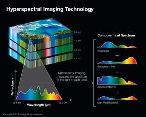
Hyperspectral remote sensing is the process of collecting and analysing electromagnetic information across many narrow and closely spaced wavelength bands.
Unlike conventional imagery, which may record only a few broad bands, hyperspectral sensors can capture hundreds of spectral bands. Consequently, each pixel can contain a detailed spectral profile.
This profile acts like a spectral fingerprint. Since different materials have different spectral responses, analysts can distinguish materials that may look almost identical in ordinary imagery.
How Does Hyperspectral Remote Sensing Work?
The basic process follows a simple sequence:
Energy → Surface interaction → Sensor → Spectral data → Analysis
When electromagnetic energy reaches the Earth’s surface, different materials absorb and reflect different wavelengths. A hyperspectral sensor records these variations across numerous narrow bands.
The resulting dataset contains two important types of information:
- Spatial information – where something is located.
- Spectral information – how it responds across different wavelengths.
Afterward, specialized software can analyse these patterns to identify materials, classify land cover, or detect subtle changes.
Hyperspectral vs. Multispectral Remote Sensing
One of the easiest ways to understand hyperspectral remote sensing is to compare it with multispectral remote sensing.
| Multispectral Remote Sensing | Hyperspectral Remote Sensing |
|---|---|
| Uses several broad spectral bands | Uses many narrow spectral bands |
| Bands are often separated | Bands are closely and continuously spaced |
| Suitable for broad land-cover classification | Provides detailed material identification |
| Produces less spectral data | Produces larger and more detailed datasets |
For example, a multispectral sensor may have separate red, green, blue, and near-infrared bands. In contrast, a hyperspectral sensor can measure hundreds of much narrower wavelength ranges.
Therefore, the greater spectral detail is one of the main advantages of hyperspectral imagery.
What Is Hyperspectral Remote Sensing Used For?
Hyperspectral remote sensing has applications across several industries.
1. Mineral Exploration
Hyperspectral imagery is particularly valuable in geology and mineral exploration. Different minerals have distinctive spectral responses. By analysing these responses, researchers can identify mineral-related patterns and areas that require further geological investigation.
Common applications include:
- Mineral identification
- Geological mapping
- Hydrothermal alteration mapping
- Exploration targeting
- Surface mineral classification
Therefore, hyperspectral data can provide valuable information before detailed field investigations begin.
2. Agriculture
Hyperspectral remote sensing can provide detailed information about vegetation and crops. Since plants interact with electromagnetic energy differently depending on their condition, hyperspectral imagery can reveal subtle variations that standard imagery may miss.
Applications include:
- Crop health monitoring
- Nutrient assessment
- Plant stress detection
- Disease monitoring
- Crop classification
- Precision agriculture
As a result, hyperspectral imagery can support more detailed agricultural analysis.
3. Environmental Monitoring
Hyperspectral data can help identify environmental changes by detecting differences in the spectral properties of land and water.
For example, professionals can use it for vegetation monitoring, habitat assessment, soil analysis, pollution detection, and environmental change studies.
The detailed spectral information is especially useful when researchers need to distinguish between materials that appear similar in conventional imagery.
4. Water Quality Monitoring
Hyperspectral sensors can detect spectral differences associated with characteristics of water bodies. This capability can support studies involving:
- Water quality
- Algal blooms
- Suspended materials
- Sediment
- Aquatic vegetation
Consequently, researchers can investigate changes across lakes, rivers, reservoirs, and coastal environments.
5. Forestry
Hyperspectral imagery can also provide detailed information about vegetation and forest conditions. Different plant species may have distinct spectral characteristics, making hyperspectral data useful for detailed vegetation analysis.
Potential applications include:
- Species identification
- Forest health monitoring
- Vegetation stress detection
- Forest structure studies
- Disease assessment
What Makes Hyperspectral Remote Sensing Different?
The main advantage of hyperspectral remote sensing is its spectral detail.
A conventional photograph mainly shows what something looks like. Multispectral imagery provides information across several wavelength ranges. Hyperspectral imagery goes further by providing a much more detailed spectral description of each pixel.
Because of this, analysts can identify differences between materials that may remain difficult to detect with conventional imagery.
For instance, two types of vegetation may appear almost identical in visible imagery but show different spectral responses at other wavelengths.
What Are the Challenges of Hyperspectral Remote Sensing?
Despite its advantages, hyperspectral remote sensing also presents several challenges.
Large Data Volumes
Hyperspectral sensors collect many spectral bands, so the resulting datasets can be significantly larger than conventional imagery. Therefore, projects may require considerable storage and processing capacity.
Complex Data Analysis
Interpreting hundreds of spectral bands can be more complicated than analysing a small number of multispectral bands. Consequently, professionals often need specialized software and technical knowledge.
Atmospheric Effects
Atmospheric conditions can influence the energy detected by a sensor. For this reason, atmospheric correction may be necessary before professionals analyse the imagery.
Cost and Availability
Hyperspectral sensors and datasets can be more specialized and less widely available than common multispectral imagery. As a result, access may be more limited for some projects.
Hyperspectral Remote Sensing and GIS
Hyperspectral remote sensing and GIS can work together to show where specific materials or environmental conditions occur.
For example, professionals can process hyperspectral imagery to identify a particular mineral or vegetation characteristic. They can then bring the results into a GIS environment to:
- Map its distribution
- Calculate affected areas
- Compare locations
- Combine the results with geological or environmental data
- Produce decision-support maps
Thus, integrating hyperspectral remote sensing with GIS creates a powerful approach to spatial analysis and mapping.
Is Hyperspectral Remote Sensing the Same as Remote Sensing?
No. Remote sensing is the broader field of collecting information about objects or areas from a distance.
In comparison, hyperspectral remote sensing is a specialized type of remote sensing that focuses on collecting highly detailed spectral information.
In simple terms:
Remote sensing is the broader technology, while hyperspectral remote sensing is a specialized approach within it.
Conclusion
Hyperspectral remote sensing provides a detailed way to observe the Earth’s surface by collecting information across many narrow spectral bands.
Its ability to capture detailed spectral signatures makes it valuable for mineral exploration, agriculture, environmental monitoring, forestry, and water-quality studies.
Although hyperspectral data can be more complex and demanding to process than conventional multispectral imagery, the additional spectral information can reveal differences that might otherwise remain hidden.
As remote sensing technology continues to develop, hyperspectral imagery will remain an important tool for researchers and professionals who need detailed information about the Earth’s surface.















































































