

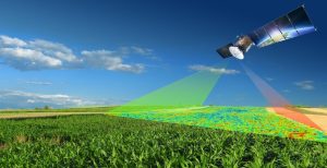
Agriculture remains an important part of Nigeria’s economy and provides livelihoods for millions of people. However, managing large farms can be difficult when farmers rely mainly on traditional methods to understand crop conditions, soil variation, water availability, and other factors.
Precision agriculture in Nigeria offers a more data-driven approach.
Instead of treating an entire farm as if every part has the same conditions, precision agriculture uses technology to identify differences across a field. Farmers can then make more informed decisions about where to plant, irrigate, fertilise, or investigate potential problems.
One of the technologies making this possible is remote sensing. Satellite imagery, drones, and other sensors can provide valuable information about agricultural fields without requiring farmers to physically inspect every part of a farm.
What Is Precision Agriculture?
Precision agriculture is an approach to farm management that uses data and technology to understand variations within agricultural land.
A large farm may contain areas with different soil conditions, moisture levels, crop health, and productivity. Consequently, applying the same treatment everywhere may not always produce the best results.
Precision agriculture aims to identify these variations and use location-specific information to improve farm management.
This is where GIS, remote sensing, GPS, drones, and other geospatial technologies become useful.
How Does Remote Sensing Support Precision Agriculture?
Remote sensing allows farmers and agricultural professionals to collect information about crops and farmland from a distance.
Satellites and drones can capture images across different wavelengths. Some of these wavelengths reveal information that ordinary photographs cannot show.
For example, healthy vegetation typically reflects near-infrared energy strongly. By analysing these spectral responses, professionals can identify differences in vegetation conditions across a farm.
The process generally involves:
- Collecting satellite or drone imagery.
- Processing the imagery to remove errors and improve its quality.
- Analysing vegetation, soil, or moisture-related information.
- Combining the results with GIS and field data.
- Using the findings to support farm management decisions.
Crop Health Monitoring
One of the most useful applications of remote sensing in agriculture is monitoring crop health.
Satellite imagery can show differences in vegetation across a farm. Areas with healthy crops may produce different spectral responses from areas experiencing stress.
Vegetation indices such as NDVI can help quantify these differences.
For instance, if one section of a farm shows significantly lower vegetation index values than surrounding areas, farmers can investigate possible causes. These may include water stress, pests, disease, nutrient deficiencies, or poor soil conditions.
Therefore, remote sensing can help farmers identify potential problems before they become widespread.
Crop Mapping and Farm Monitoring
Knowing exactly where crops are located is important for effective agricultural management.
Remote sensing can help map cultivated areas and distinguish agricultural land from other land-cover types. This information can support farm inventories, crop monitoring, and agricultural planning.
Furthermore, satellite imagery allows professionals to monitor farms repeatedly throughout a growing season.
This repeated observation makes it possible to track changes rather than relying on a single field visit.
Monitoring Soil and Moisture Conditions
Water availability can significantly affect crop productivity.
Remote sensing can provide information that helps identify variations in surface conditions and vegetation stress. When combined with weather, soil, and field observations, these datasets can help agricultural professionals understand where water may be limited.
GIS can then display these variations spatially, allowing farmers to identify areas that may require closer attention.
Using Drones for Precision Agriculture
Satellites are useful for monitoring large agricultural areas, but drones offer another advantage: very high spatial resolution.
A drone can capture detailed imagery over a specific farm and reveal variations that may not be visible in lower-resolution satellite imagery.
For example, agricultural professionals can use drone imagery to inspect crop rows, identify stressed vegetation, map irrigation systems, and monitor specific sections of a farm.
However, drones typically cover smaller areas than satellites. Therefore, both technologies can complement each other.
The Role of GIS in Precision Agriculture
Remote sensing provides the data, while GIS helps organise, analyse, and visualise it.
A GIS platform can combine satellite imagery with farm boundaries, soil information, elevation, rainfall, roads, irrigation infrastructure, and field observations.
For example, a farmer could use GIS to identify areas with low vegetation health and compare them with soil or elevation data. This additional context may help explain why certain parts of the farm are performing differently.
Consequently, combining GIS and remote sensing provides a more complete picture of agricultural conditions.
Benefits of Precision Agriculture in Nigeria
The adoption of precision agriculture can provide several benefits for Nigerian farmers and agricultural organisations.
1. Better Resource Management
Farmers can apply inputs more strategically instead of treating every part of a farm in exactly the same way.
2. Early Problem Detection
Remote sensing can reveal unusual crop conditions that may require field investigation.
3. Improved Farm Monitoring
Satellite imagery allows professionals to monitor large agricultural areas without visiting every location.
4. Data-Driven Decisions
Combining remote sensing, GIS, weather information, and field observations provides stronger evidence for agricultural decisions.
Challenges of Precision Agriculture in Nigeria
Despite its potential, precision agriculture still faces challenges in Nigeria.
The cost of equipment and specialised services can be a barrier for some farmers. Internet access, availability of high-quality field data, technical skills, and awareness can also affect adoption.
In addition, satellite imagery may experience limitations from cloud cover, particularly during periods of heavy rainfall. Drone operations also require appropriate equipment, skilled operators, and compliance with relevant regulations.
Therefore, successful adoption requires not only technology but also training, infrastructure, and accessible agricultural services.
Precision Agriculture in Nigeria: The Future
As satellite data, drones, GIS platforms, and agricultural technologies become more accessible, precision agriculture has significant potential in Nigeria.
Large commercial farms can use detailed geospatial information to improve operations, while agricultural organisations can use satellite data to monitor crops across much larger regions.
In the future, the integration of remote sensing, artificial intelligence, machine learning, IoT sensors, weather data, and GIS could make agricultural monitoring even more precise.
How GeoInfotech Can Help
Turning satellite and drone imagery into useful agricultural information requires the right data, processing methods, and spatial analysis.
If you need agricultural mapping, remote sensing analysis, GIS services, drone mapping, NDVI analysis, crop monitoring, or other geospatial solutions, GeoInfotech can support your project with practical geospatial services.
Whether you need to monitor vegetation, map farmland, analyse crop conditions, or develop a location-based agricultural workflow, the right geospatial data can help turn complex information into actionable insights.
Conclusion
Precision agriculture in Nigeria is becoming increasingly relevant as farmers and agricultural organisations look for better ways to manage resources and improve productivity.
Remote sensing provides an efficient way to monitor crops, map farmland, identify vegetation differences, and observe agricultural changes over time. When combined with GIS, drone technology, field observations, and other datasets, it becomes an even more powerful tool for modern farm management.
Nigeria has significant agricultural potential. By adopting practical geospatial technologies and improving access to agricultural data, farmers can make more informed decisions and manage their resources more efficiently.















































































