 Precision agriculture is becoming increasingly important for Nigerian farmers and agribusinesses that want to make decisions using data rather than guesswork. But one question often comes first: how much does precision agriculture cost in Nigeria?
The short answer is that there is no single fixed price. The cost depends on the size of the farm, type of imagery or sensors required, number of monitoring missions, location, processing requirements and the level of analysis delivered.
What Does Precision Agriculture Include?
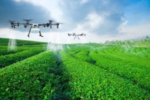
Precision agriculture can involve several technologies working together. These may include drone mapping, multispectral imaging, NDVI and NDRE analysis, satellite imagery, GPS field mapping, soil monitoring and GIS-based farm intelligence.
A basic crop-monitoring project may only require vegetation maps. A more advanced engagement could involve repeated drone flights, crop-health analysis, prescription maps and field recommendations.
That difference has a major effect on the final price.
How Much Does Drone Crop Analysis Cost?
Published Nigerian market estimates show that agricultural drone monitoring can range from hundreds of thousands to several million naira depending on farm size and analytical scope. One recent Nigerian estimate places a 500-hectare drone crop-health survey at approximately ₦500,000 to ₦2 million, depending on the engagement and analysis required.
However, these figures should be treated as planning references rather than fixed national tariffs.
For example, a small farm requiring one multispectral survey will have very different costs from a large commercial estate requiring monthly monitoring throughout an entire growing season.
What Determines Precision Agriculture Pricing?
The main cost factors include:
1. Farm size: Larger areas require more flight time, imagery and processing.
2. Sensor technology: Standard RGB cameras are generally less complex than multispectral or thermal sensors.
3. Monitoring frequency: A one-time assessment costs differently from a seasonal monitoring program.
4. Data processing: Raw imagery is different from a complete analytical package containing NDVI maps, crop-health zones and actionable reports.
5. Location and logistics: Travel, site accessibility, terrain and operating conditions can affect project costs.
6. Required accuracy and deliverables: Orthomosaics, GIS layers, vegetation indices, reports and prescription maps each add different levels of processing.
This is why comparing quotes based only on the price per hectare can be misleading. The real question is what information and deliverables are included.
How Much Does NDVI Mapping Cost?
NDVI mapping can form part of a broader drone crop-analysis package rather than being priced independently.
The process involves capturing multispectral imagery and calculating vegetation indices to identify differences in crop vigor. NDVI can help reveal spatial patterns associated with crop stress, uneven growth and other field conditions.
More advanced monitoring may combine NDVI with NDRE, GNDVI, MSAVI, thermal imagery, weather information and field observations. Nigerian agricultural technology providers already offer crop-monitoring platforms using several of these indices, with some subscription-based services priced per hectare and per season.
Is Precision Agriculture Worth the Cost?
The value of precision agriculture comes from the decisions the data supports.
Instead of treating an entire farm as uniform, farmers can identify areas that require closer inspection, monitor changes over time and target inputs where they are most needed.
The goal is therefore not simply to produce a colorful NDVI map. It is to turn spatial data into practical farm intelligence.
For farms requiring drone-based crop mapping, multispectral analysis and geospatial interpretation, GeoInfotech’s agriculture services provide a relevant example of how aerial data can be incorporated into agricultural decision-making.
Final Consideration
When requesting a precision agriculture quotation in Nigeria, provide the farm area, crop type, location, monitoring frequency and required outputs. Ask whether the quotation includes drone operation, multispectral data, processing, NDVI analysis, GIS deliverables and reporting.
Ultimately, precision agriculture should be priced around the problem being solved and the intelligence being delivered, not simply the number of hectares flown.
As Nigerian agriculture becomes increasingly data-driven, drone mapping and farm intelligence can provide farmers with a clearer view of what is happening across their fields and where action may be needed.