

Every year, Nigerians lose money through land scams, double sales, and government acquisition issues. In many cases, the problem starts with one missed step: a proper land survey.
A land survey does more than measure a plot. It defines the property’s boundaries and provides important evidence of ownership. It can also help buyers identify potential disputes or government acquisition before they invest.
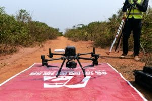
Drone technology has changed how many surveyors collect this information. Today, UAVs support land surveying, aerial mapping, and large-scale site analysis across Nigeria.
However, drone technology does not replace the professional surveyor. A licensed surveyor still plays a key role in producing and registering an official survey plan.
This guide explains how drone surveying in Nigeria works. It also covers aerial mapping, photogrammetry, survey accuracy, costs, registration, and the role of licensed surveyors.
What Is a Land Survey and Why Is It Important?
A land survey measures and maps the exact location and boundaries of a property. A licensed surveyor carries out the work using professional surveying equipment and established procedures.
The final survey plan shows important property information. This can include coordinates, dimensions, boundaries, and ownership details.
A registered survey plan can provide important legal protection for a landowner. It can also help identify issues before a property transaction takes place.
For this reason, buyers should not treat a land survey as an optional step.
What Can Happen Without a Proper Survey?
Buying land without proper checks can create serious problems.
A property may fall within a government acquisition area. It may also overlap with another person’s property.
Boundary disputes can create additional costs and delays. A seller may also advertise a plot as larger than its actual size.
A proper survey can help identify these issues before the buyer commits funds.
One documented case involved a Lagos buyer who purchased two plots in 2018 without commissioning a proper survey. A later check showed that part of the land fell under government acquisition for a road expansion project.
The buyer reportedly lost close to ten million naira. A survey before the purchase could have helped reveal the acquisition status earlier.
Where Do Drones Fit Into Land Surveying?
Drones have become useful tools for modern surveying projects.
A UAV can cover large areas quickly. This makes drone surveying useful for estates, farms, infrastructure projects, mining sites, and other large properties.
A professional drone carries a high-resolution camera and positioning technology. During a planned flight, it captures hundreds or thousands of overlapping images.
Photogrammetry software then processes these images. The result can include an orthomosaic, 3D model, elevation model, or other mapping products.
The drone provides the data collection platform. The licensed surveyor remains responsible for the professional surveying process and official submission.
Drone Surveying and Traditional Ground Surveying
Drone surveying does not make traditional surveying equipment unnecessary.
Instead, both methods can work together.
Drones are useful when a project covers a large area. They can collect aerial information much faster than a ground team working alone.
Ground equipment remains important for precise measurements at specific points. Surveyors may use GNSS receivers, total stations, and ground control points alongside drone imagery.
This combined approach can improve efficiency while maintaining the accuracy required for the project.
Aerial Mapping and Photogrammetry
Photogrammetry is one of the technologies behind modern drone mapping.
The process uses overlapping photographs to create measurements and spatial information. Software compares common points across multiple images.
The system can then calculate locations, distances, and elevation.
However, good results depend on more than the drone camera.
The project needs proper flight planning. It may also require GNSS positioning, ground control points, and RTK or PPK correction.
These elements can improve positional accuracy.
What Is RTK and PPK?
RTK stands for Real-Time Kinematic. PPK means Post-Processed Kinematic.
Both technologies improve the positioning information collected during a drone survey.
RTK can provide corrections during the flight. PPK applies corrections during data processing.
The appropriate system depends on the project requirements.
For engineering, cadastral, and other high-accuracy applications, professional surveyors may combine RTK or PPK technology with ground control points.
What Is the Difference Between a Drone Photo and a Drone Survey?
Aerial photography and drone surveying are not the same thing.
A drone photograph provides a visual view of a location. It can be useful for marketing, inspection, documentation, or general site monitoring.
A drone survey produces measurable geospatial information.
The difference comes from the equipment, flight planning, positioning, control points, processing, and professional workflow.
For a legally relevant survey, the work must follow the appropriate professional and regulatory requirements.
Modern Tools Used in Nigerian Surveying
Modern surveying combines several technologies.
GNSS receivers provide accurate positioning information. Drones capture aerial imagery across large areas.
Total stations measure angles and distances at specific points. GIS software helps surveyors manage and analyse spatial data.
CAD software supports the preparation of technical drawings and plans. LiDAR can also provide detailed three-dimensional information for suitable projects.
No single tool works best for every situation.
A professional surveyor selects the equipment based on the size, terrain, accuracy requirements, and purpose of the project.
Step-by-Step Process for a Registered Survey Plan in Nigeria
The process begins with a licensed surveyor.
The surveyor should confirm the property’s location and relevant ownership information. A reconnaissance visit can then help assess the site.
Next comes field data collection.
The surveyor may use GNSS equipment, drones, total stations, and other tools. The collected information supports the preparation of the survey plan.
The plan can then move through the applicable registration process with the relevant State Ministry of Lands.
Government records can help identify issues such as overlaps or acquisition.
Fees and other requirements vary by state.
Once the process is completed, the registered survey plan provides the official record required for the applicable property process.
The total time can vary. Processing speed depends on the state, project, documentation, and government workflow.
How Much Does Land Surveying Cost in Nigeria?
Survey costs vary across Nigeria.
The price can depend on location, land size, survey type, terrain, equipment, and registration requirements.
Market estimates in the source material provide the following general ranges:
- Lagos: ₦350,000 to ₦2 million
- Abuja and FCT: ₦500,000 to ₦3 million
- Ogun State: ₦250,000 to ₦800,000
- Some rural areas: ₦150,000 to ₦400,000
These figures should serve only as general planning estimates.
A boundary survey may cost less than a detailed topographic or drone survey. Large sites can also require additional fieldwork and data processing.
Before starting, request a written quotation.
The quotation should clearly separate professional fees, fieldwork, government charges, and other costs.
Common Problems a Proper Land Survey Can Prevent
A proper survey can reveal several property problems.
Government Acquisition
A survey can help identify whether a property falls within an acquisition area or other government restriction.
Boundary Disputes
Accurate coordinates can help establish the actual limits of a property.
Double Allocation
Survey information can help reveal potential overlaps with existing plots.
Incorrect Land Size
A survey measures the actual property dimensions instead of relying only on a seller’s description.
Construction Errors
Developers can use accurate survey information to position structures correctly before construction begins.
These checks can save significant time and money later.
How to Choose a Land Surveyor in Nigeria
Start by checking the surveyor’s professional registration.
Ask for evidence of relevant experience. You can also request examples of previous survey work.
Local knowledge can matter too. Survey requirements and processes can vary between states and locations.
Make sure the scope of work is clear before paying.
The agreement should explain the fieldwork, survey plan, registration process, government fees, and professional charges.
It is also useful to ask about the technology the surveyor uses.
Modern equipment such as GNSS, drones, GIS, and total stations can improve efficiency on suitable projects.
Documents Needed for Land Registration
The exact requirements can vary by state and application type.
Common documents may include a registered survey plan, application forms, proof of identity, purchase documents, passport photographs, and payment receipts.
Prepare the documents before starting the process.
This can reduce unnecessary delays and repeated visits to government offices.
Always confirm the current requirements with the relevant authority or a qualified professional.
Drone Surveying for Large Sites
Large properties can benefit significantly from UAV mapping.
A drone can cover extensive areas faster than a small ground team working alone. This makes the technology useful for estates, farms, mining sites, and infrastructure projects.
The aerial data can support several outputs.
These may include:
- Orthomosaic maps
- Topographic maps
- Digital elevation models
- 3D terrain models
- Contour maps
- Site measurements
- Volumetric calculations
The required output depends on the purpose of the survey.
Drone Surveying with Geoinfotech
Geoinfotech combines licensed land surveying with drone and DGNSS technology for projects across Nigeria.
The company has documented experience with different surveying applications. These include drone topographic surveying for land development in Igabi, Kaduna State.
Its project experience also includes precision topographic mapping for mining site planning in Jos.
Other work includes aerial topographic surveying for land development in Ogun State.
Geoinfotech has also completed drone survey and mapping work covering 500 hectares in Akwa Ibom State. Its ground control work extends across Kano, Katsina, Jigawa, and Kaduna.
This experience supports both small property surveys and larger mapping projects.
For individuals and businesses, Geoinfotech can combine GPS, drone, and GIS technology with licensed surveying services.
For developers, mining companies, and infrastructure teams, the same technology can support large-area mapping and site planning.
You can contact Geoinfotech through geoinfotech.ng or call +234 816 322 2177.
The company has a Lagos office at Oluwalogbon House, Obafemi Awolowo Way, Alausa, Ikeja. It also has an Abuja office at the Nigeria Reinsurance Corporation Building, Plot 784A Herbert Macaulay Way.
How to Start a Drone Survey in Nigeria
Start by identifying what you need to achieve.
A property buyer may need a boundary survey. A developer may need topographic mapping.
A mining company may require large-area terrain mapping. An agricultural business may need aerial mapping of farmland.
Once the objective is clear, a surveyor can recommend the appropriate equipment and workflow.
The survey team can then plan the flight and ground measurements.
After data collection, the team processes the imagery and other survey information.
Finally, the licensed surveyor reviews the results and prepares the required documentation.
Frequently Asked Questions About Drone Surveying in Nigeria
Is drone surveying legal in Nigeria?
Drone operations must follow applicable Nigerian aviation and professional requirements.
Projects should use qualified professionals who understand the relevant rules.
Can a drone replace a land surveyor?
No.
A drone is a data collection tool. A licensed surveyor remains essential for professional surveying and the applicable registration process.
How accurate is drone surveying?
Accuracy depends on the equipment, positioning system, ground control, flight planning, terrain, and processing method.
RTK, PPK, and ground control points can support high-accuracy applications.
Can drones survey large areas?
Yes.
Drones are particularly useful for large sites because they can collect aerial data quickly.
The required aircraft and flight plan depend on the site’s size and project requirements.
Can drone surveys be used for construction?
Yes.
Drone surveys can support site planning, topographic mapping, progress monitoring, and terrain analysis.
The required survey method depends on the project’s accuracy and documentation requirements.
How much does a drone survey cost in Nigeria?
There is no single national price.
Site size, location, survey type, equipment, accuracy requirements, processing, and reporting can all affect the cost.
A project-specific quotation provides a more reliable estimate.
The Bottom Line
A proper land survey remains an important step when buying or developing property in Nigeria.
It can help identify boundaries, acquisition issues, overlaps, and other potential problems before they become expensive disputes.
Drone surveying has added a powerful tool to the modern surveyor’s workflow.
UAVs can capture detailed aerial information across large areas. Photogrammetry can then turn that imagery into useful geospatial data.
However, the technology does not replace professional surveying.
The best results come from combining drones with GNSS, ground control, GIS, and the expertise of a licensed surveyor.
For landowners, developers, mining companies, farmers, and infrastructure teams, drone surveying in Nigeria can provide a faster and more efficient way to collect detailed information about large or complex sites.
The key is to work with a qualified survey professional who can turn that aerial data into accurate, usable, and properly documented survey information.















































































