

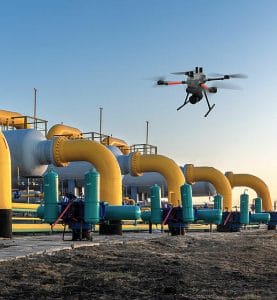
Drone surveillance Nigeria in Nigeria is becoming an important tool for monitoring oil and gas infrastructure. Companies can use drones to inspect pipelines, facilities, right-of-way corridors, and other critical assets.
Nigeria’s oil and gas industry operates across large and complex areas. These areas include pipelines, flow stations, processing facilities, terminals, and offshore assets.
Monitoring these assets can present major challenges. Some facilities sit in remote locations. Pipeline networks can also stretch across difficult terrain.
Traditional inspection methods often require teams to travel long distances. This process can take time and increase operational costs.
Drone surveillance for oil and gas facilities in Nigeria offers another approach. UAVs can provide aerial imagery, live video, mapping data, and inspection information.
Operators can use this information to understand conditions on the ground. They can also identify areas that require closer inspection.
This guide explains how drones support oil and gas operations in Nigeria. It covers pipeline surveillance, facility inspection, right-of-way monitoring, security, mapping, and environmental monitoring.
What Is Drone Surveillance for Oil and Gas Facilities?
Drone surveillance uses unmanned aerial vehicles to monitor oil and gas assets.
A drone can carry different cameras and sensors. These may include high-resolution cameras, thermal cameras, and infrared sensors.
Operators control the aircraft from a safe location. Many professional drones can also transmit live video during a mission.
This capability provides a useful aerial view of large facilities and remote assets.
Oil and gas companies can use drones for routine inspections. They can also deploy them when an incident requires immediate aerial information.
Why Oil and Gas Companies in Nigeria Use Drones
Oil and gas infrastructure can cover large areas.
A pipeline may cross several communities and difficult terrain. A single facility may also contain multiple structures that require regular inspection.
Ground teams can inspect these locations. However, the process may take considerable time.
Drones provide a faster way to obtain aerial information.
An operator can plan a flight along a pipeline corridor. The drone can then capture images and video across the selected area.
This information helps inspection teams understand current site conditions.
Drones can also reduce the need to send personnel into certain areas during the initial assessment.
Drone Pipeline Inspection in Nigeria
Pipeline inspection is one of the major applications of UAV technology in the oil and gas sector.
Pipelines require regular monitoring. Operators need to understand their condition and identify visible changes around the pipeline corridor.
A drone can fly along a planned route. Its camera can capture high-resolution images of the pipeline and surrounding area.
The collected data can help teams identify visible issues. These may include vegetation growth, construction activity, erosion, exposed sections, or other changes around the right-of-way.
Drone inspections can also support follow-up work.
When the aerial survey identifies an area of concern, the inspection team can focus its attention on that location.
Pipeline Right-of-Way Monitoring
A pipeline right-of-way refers to the corridor around a pipeline.
Operators need to monitor these corridors regularly. Changes around the corridor can affect pipeline access and operational safety.
Large pipeline networks make ground monitoring difficult.
Drones can cover long sections of a right-of-way during planned missions. The operator can follow a predetermined flight route and collect consistent imagery.
This approach can help companies maintain records of changing conditions.
Regular flights can also provide comparison data over time.
For example, a company can compare imagery from different inspection periods. This may help teams identify changes that require further investigation.
How Drones Support Pipeline Security
Pipeline security presents another important application.
Oil and gas companies need to monitor areas around their infrastructure. Unauthorized activities can create security and operational risks.
Aerial monitoring gives security teams another view of the pipeline corridor.
Drones can inspect areas that ground teams may find difficult to access. Operators can also redirect the aircraft when a team identifies an area that requires closer observation.
Thermal cameras can provide additional capabilities during suitable nighttime operations.
However, organizations should use drone surveillance as part of a wider security strategy. Drones should complement established security procedures and response teams.
Drone Surveillance for Oil and Gas Facilities
Oil and gas facilities contain many structures and operational areas.
These may include flow stations, storage facilities, processing plants, terminals, and compressor stations.
Routine inspection helps operators understand the condition of these assets.
Drones can capture detailed aerial images of facility structures. They can also provide an overview of the surrounding site.
This aerial perspective can help inspection teams plan their work.
Instead of sending personnel to every part of a large facility immediately, teams can first review aerial information.
The results can then guide more detailed inspections.
Aerial Inspection of Flow Stations and Processing Facilities
Flow stations and processing facilities contain complex equipment.
Inspectors may need to assess roofs, structures, tanks, pipelines, and other components.
Some areas can present access challenges.
Drones can capture imagery from different angles without requiring an inspector to reach every location immediately.
High-resolution cameras can support visual inspection. Thermal cameras can provide additional information where heat detection forms part of the inspection requirement.
The drone data can also support inspection reports and maintenance planning.
Drone Monitoring for Offshore Oil and Gas Infrastructure
Offshore operations create unique monitoring challenges.
Facilities may sit far from the mainland. Access often requires boats, helicopters, or other transport arrangements.
Drones can provide an additional monitoring option.
Depending on the aircraft and operating conditions, UAVs can collect aerial imagery around offshore infrastructure.
Operators can use the footage to assess visible conditions around platforms and other assets.
Drone missions can also support maritime monitoring.
The aircraft can provide an aerial view of surrounding activity when the operation and regulations permit it.
Thermal Drone Inspection for Oil and Gas
Thermal cameras can add another layer of information to drone inspections.
A thermal sensor detects differences in heat rather than relying only on visible light.
This capability can support certain inspection tasks.
For example, operators can use thermal imaging to identify unusual heat patterns around suitable equipment.
Thermal cameras can also support some nighttime monitoring activities.
However, thermal imagery does not replace physical inspection.
Teams should interpret thermal information alongside other inspection data.
Drone Mapping for Oil and Gas Infrastructure
Mapping is another important UAV application.
A drone can capture aerial images across a defined area. Specialized software can process these images into maps and three-dimensional models.
Oil and gas companies can use these outputs for planning and monitoring.
Drone mapping can support pipeline corridor surveys. It can also help with facility mapping, site documentation, and construction monitoring.
Accurate geospatial information can make it easier for teams to understand the location and condition of infrastructure.
Environmental Monitoring With Drones
Oil and gas operations can interact with large natural environments.
Companies therefore need to monitor surrounding areas as part of responsible operations.
Drones can provide aerial imagery of vegetation, waterways, land surfaces, and other environmental features.
Regular surveys can help teams document changes over time.
The imagery can also support environmental assessments and field investigations.
However, organizations should select sensors and flight plans according to the specific monitoring objective.
Drone Surveillance for Oil and Gas Security
Security teams can use UAVs to improve situational awareness.
Aerial surveillance provides a different perspective from ground patrols.
Drones can inspect large areas quickly. Operators can also direct the aircraft toward locations that require attention.
This flexibility can help security teams gather information before sending personnel into an area.
The technology can support monitoring around facilities, pipeline corridors, storage areas, and other assets.
Organizations should still integrate drones with their existing security systems.
Benefits of Drone Surveillance in the Oil and Gas Industry
Drone technology provides several practical benefits.
Faster Inspections
Drones can collect aerial information quickly. This can reduce the time required for initial site assessments.
Wide-Area Coverage
A suitable UAV can cover large areas during a single mission.
Reduced Exposure
Drones can inspect some locations before personnel enter the area.
This can help teams assess conditions from a safer position.
High-Resolution Data
Professional cameras can capture detailed images of infrastructure and surrounding areas.
Real-Time Monitoring
Some UAV systems can transmit live video during flight.
This helps teams receive information while the mission continues.
Repeatable Surveys
Operators can plan repeat missions using consistent flight paths.
This creates useful data for comparing site conditions over time.
Drone Surveillance vs Traditional Oil and Gas Inspection
Traditional inspections remain important within the oil and gas industry.
However, they can require significant personnel and logistical resources.
Drones provide an additional inspection method.
A UAV can collect aerial information before a ground team begins a detailed inspection.
This approach can help companies identify priority areas.
It can also reduce unnecessary travel across large sites.
Drones do not replace experienced inspectors. Instead, they provide another tool that can improve the inspection workflow.
What Equipment Is Needed for Oil and Gas Drone Inspection?
Equipment requirements depend on the mission.
A basic operation may require a professional UAV and high-resolution camera.
More advanced missions may require additional equipment.
A professional setup may include:
- Industrial drone
- High-resolution camera
- Thermal camera
- Infrared sensor
- Extra batteries
- Ground control equipment
- Live video transmission system
- Flight planning software
- Mapping software
- Data storage equipment
- Safety equipment
The operating environment should guide the final equipment selection.
A short facility inspection may need different equipment from a long pipeline survey.
Drone Regulations for Oil and Gas Operations in Nigeria
Organizations must consider aviation regulations before conducting professional drone operations.
The Nigeria Civil Aviation Authority (NCAA) regulates civil aviation activities in Nigeria. Its framework includes requirements that apply to remotely piloted aircraft systems.
Companies should understand the applicable requirements before starting commercial UAV operations.
Regulatory planning should form part of the project from the beginning.
Operators should also consider privacy, data management, safety, and site-specific restrictions.
Working with trained professionals can help organizations manage these requirements.
How to Choose an Oil and Gas Drone Service Provider
Choosing the right provider requires more than comparing drone models.
First, consider the provider’s experience.
A company that understands industrial inspection can better plan missions around operational requirements.
Next, examine the equipment.
Check whether the provider has suitable cameras, thermal sensors, mapping tools, and aircraft for the proposed mission.
Pilot training also matters.
Professional operations require trained personnel who understand flight planning, safety, data collection, and reporting.
Finally, ask about regulatory compliance.
A professional provider should understand the requirements for commercial UAV operations in Nigeria.
Drone Surveillance Services in Lagos
Organizations searching for drone surveillance services in Lagos can work with professional UAV providers.
Lagos has major industrial, commercial, maritime, and infrastructure operations.
Businesses may require aerial inspection for facilities, construction sites, infrastructure, and security operations.
When selecting a provider, consider its technical capabilities and experience.
Ask about the aircraft, sensors, pilot qualifications, data processing, and reporting process.
A proper site assessment can also help determine the most suitable solution.
Oil and Gas Drone Services in Nigeria
Oil and gas companies can use drone services for several applications.
These include:
- Pipeline inspection
- Right-of-way monitoring
- Facility inspection
- Security surveillance
- Thermal inspection
- Aerial mapping
- Environmental monitoring
- Construction monitoring
- Infrastructure documentation
The right service depends on the company’s operational objective.
Some projects may require a single inspection. Others may need regular monitoring throughout the year.
A professional UAV provider can help determine the appropriate approach.
Frequently Asked Questions
What is drone surveillance in the oil and gas industry?
Drone surveillance uses UAVs to monitor oil and gas assets.
Operators can collect images, video, thermal data, and mapping information.
Companies can use this data for inspection, security, monitoring, and planning.
Can drones inspect oil pipelines in Nigeria?
Yes.
Drones can capture aerial imagery along pipeline corridors.
The data can help teams identify visible changes and areas that require closer inspection.
Can drones monitor pipeline right-of-way areas?
Yes.
Drones can follow planned routes along pipeline corridors.
They can capture imagery that helps companies monitor changes around the right-of-way.
Can drones detect pipeline leaks?
Drones can support leak detection when equipped with suitable sensors.
However, the exact capability depends on the type of leak, sensor technology, environmental conditions, and aircraft.
Drone data should therefore form part of a wider inspection process.
Can drones monitor oil and gas facilities at night?
Some professional UAVs can support nighttime operations.
Thermal and infrared sensors can improve visibility in low-light conditions.
Operators must still follow applicable aviation and operational requirements.
What are the benefits of drone inspection for oil and gas companies?
Drones can provide faster aerial inspections and wide-area coverage.
They can also reduce the need for personnel to immediately access some difficult locations.
The technology can support mapping, security, infrastructure inspection, and environmental monitoring.
How much does drone inspection cost in Nigeria?
The cost varies from one project to another.
Factors include the size of the site, flight duration, aircraft type, sensors, personnel, data processing, and reporting requirements.
Companies should request a project-specific quotation.
Where can I get drone inspection services in Nigeria?
Professional UAV companies provide drone inspection and surveillance services across Nigeria.
Before selecting a provider, check its experience, equipment, pilot qualifications, safety procedures, and regulatory knowledge.
The Bottom Line
Drone surveillance for oil and gas facilities in Nigeria provides companies with a flexible way to monitor large and complex assets.
UAVs can support pipeline inspection, right-of-way monitoring, facility surveillance, mapping, security, and environmental assessments.
The technology can also provide live aerial information during suitable operations.
However, successful drone operations require more than purchasing an aircraft.
Companies need the right sensors and software. They also need trained operators and clear operating procedures.
Regulatory compliance should form part of the planning process.
Most importantly, companies should select equipment based on the mission.
A pipeline survey may require a long-endurance aircraft. A facility inspection may need a high-resolution camera. Night operations may require thermal sensors.
With the right combination of technology and expertise, UAVs can become a valuable part of an oil and gas inspection and monitoring program in Nigeria.
Organizations can also combine drone surveillance with existing inspection and security systems.
This approach provides a broader view of infrastructure while allowing teams to focus their resources on areas that require attention.















































































