

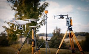
For more than a century, surveyors have relied on tools such as total stations to measure land accurately. These instruments remain essential for many surveying projects in Nigeria.
However, technology has introduced another option.
Today, developers, engineers, surveyors, and landowners can use drones to capture detailed information across large areas in a short time. This raises an important question:
Can drone land surveying in Nigeria deliver accurate results faster and at a lower cost than traditional surveying?
The answer depends on the project.
Drones can provide excellent coverage and detailed spatial data. Traditional instruments still offer advantages when a project requires highly precise individual points or legal boundary measurements.
In many cases, the best solution combines both methods.
This guide compares drone and traditional land surveying across accuracy, cost, speed, RTK, ground control points, and practical use cases.
How Traditional and Drone Land Surveying Work
The biggest difference between the two methods is how they collect spatial information.
Traditional Land Surveying
Traditional surveying uses ground-based equipment such as:
- Total stations
- GNSS receivers
- RTK rovers
- Survey prisms
- Other precision instruments
A surveyor moves across the site and measures specific points.
These points can include:
- Property corners
- Road features
- Elevation benchmarks
- Drainage structures
- Pipe inverts
- Kerb lines
- Other important site features
A total station can provide highly precise measurements for individual observed points. RTK GNSS equipment can also provide centimetre-level positioning under suitable conditions.
This approach works particularly well when a project needs a limited number of highly accurate points.
Drone Land Surveying
Drone land surveying in Nigeria takes a different approach.
Instead of measuring individual points across the entire site, the drone follows a planned flight path and captures hundreds or thousands of overlapping images.
Photogrammetry software then processes those images.
The result can include:
- Dense point clouds
- Orthomosaic maps
- Digital elevation models
- Digital terrain models
- Contour maps
- 3D models
Instead of collecting only selected points, the drone can create a detailed spatial record of the wider site.
This makes the method particularly useful for large areas.
Drone Survey vs Traditional Survey: Accuracy Comparison
Accuracy is one of the most important factors when choosing a surveying method.
However, it is not simply a case of one technology being more accurate than the other.
The two methods collect and represent spatial information differently.
Traditional instruments remain the preferred option when a project requires extremely precise individual points. Legal boundary work and high-precision engineering control can fall into this category.
Drone photogrammetry can also achieve centimetre-level accuracy when the right equipment and workflow are used.
RTK or PPK positioning can improve the drone’s georeferencing. Ground control points can provide another layer of accuracy and verification.
Therefore, the final accuracy depends on more than the aircraft.
It can also depend on:
- Flight planning
- Camera quality
- Ground control
- RTK or PPK technology
- Image overlap
- Ground conditions
- Processing software
- Survey checkpoints
- Quality-control procedures
When Traditional Surveying Has the Advantage
Traditional surveying remains the better choice when a project needs very precise individual measurements.
This can include:
- Legal boundary points
- Cadastral work
- High-precision engineering control
- Structural monitoring
- Critical benchmarks
- Specific survey points
If the project requires extremely tight tolerances, ground-based instruments may need to provide the primary measurements.
When Drone Surveying Has the Advantage
Drone surveying becomes more attractive when the project requires broad coverage.
For example, a large site may need thousands of measurements to represent its terrain.
A drone can capture the entire area from the air and generate a dense spatial dataset.
This approach can reduce the amount of time a survey crew needs to spend walking across the site.
Understanding RTK and Ground Control Points
RTK and GCPs play an important role in professional drone surveying.
What Is RTK?
RTK stands for Real-Time Kinematic positioning.
It uses correction data to improve GNSS positioning accuracy.
RTK can be used with ground survey equipment. Some professional mapping drones also have RTK positioning systems.
This technology can improve the location information attached to aerial photographs.
However, RTK does not remove the need for good survey practices.
What Are Ground Control Points?
Ground Control Points, or GCPs, are physical markers placed at known locations across a survey site.
Surveyors determine their coordinates using appropriate ground-survey equipment.
The drone then captures these markers in its aerial imagery.
Photogrammetry software can use the known coordinates to improve the georeferencing of the final dataset.
GCPs can also help with independent accuracy checks.
Why RTK and GCPs Matter
A drone can produce an attractive map without ground control.
That does not automatically mean the map has the accuracy required for engineering or legal work.
A professional workflow should consider the project’s accuracy requirements before deciding whether to use RTK, PPK, GCPs, checkpoints, or a combination of these methods.
For demanding projects, a hybrid approach can provide a strong balance.
Ground equipment establishes trusted control points. The drone then captures detailed information across the wider site.
Drone Surveying Cost vs Traditional Surveying Cost
Cost depends heavily on the project.
A small site may not benefit from a full drone mapping workflow. In such cases, a traditional surveyor may collect the required points quickly.
Large sites are different.
A traditional survey crew may need to move across the entire area to collect enough points. This increases field time and labour requirements.
A drone can capture a large area during a relatively short flight.
The processing stage does add additional work. Images must be transferred, processed, checked, and converted into the required deliverables.
Even so, the drone approach can become more cost-effective as the survey area increases.
When Traditional Surveying Can Cost Less
Traditional surveying may be more economical when:
- The site is small
- Only a few points are required
- The project focuses on property corners
- Legal boundary work is required
- The project needs specific ground measurements
- The site does not justify aerial processing
In these situations, sending a drone may create unnecessary processing costs.
When Drone Surveying Can Save Money
Drone surveying can become more economical when:
- The site is large
- Full-site coverage is required
- The project needs repeated surveys
- Terrain is difficult to access
- The project requires both imagery and elevation data
- Construction progress needs regular monitoring
- Stockpile volumes need frequent measurement
The larger the area becomes, the stronger the case for aerial data collection can become.
Speed: Which Surveying Method Is Faster?
Drone surveying often has a major advantage in field coverage.
A drone can capture a large area during a relatively short flight. A ground crew may need much longer to walk across the same area and collect individual points.
However, field time is not the entire project.
A fair comparison should include:
- Flight planning
- Ground control setup
- Field data collection
- Data transfer
- Photogrammetry processing
- Quality control
- Final data delivery
Drone surveys require processing after the flight.
Traditional surveys can sometimes provide individual measurements immediately after field collection.
Therefore, the fastest option depends on what the project needs.
For a full topographic model over a large site, drones can offer a significant time advantage.
For a few specific points, traditional surveying may be faster overall.
Drone Land Surveying: Best Use Cases
Drone surveying is particularly useful when full-site coverage matters.
Large-Area Topographic Mapping
Large properties can require extensive field measurements.
Drone photogrammetry can capture the wider area and produce a detailed spatial model.
This makes it useful for:
- Estates
- Large development sites
- Agricultural land
- Industrial facilities
- Mining areas
- Infrastructure corridors
Construction Monitoring
Construction teams can use repeated drone surveys to document changes over time.
The resulting imagery and 3D data can help teams compare the current site with earlier surveys.
This can support:
- Progress monitoring
- Site documentation
- Earthwork calculations
- Stockpile measurement
- Project reporting
Stockpile and Volume Surveys
Mining and industrial operations often need accurate volume measurements.
A drone can capture the entire stockpile and generate a 3D surface.
The resulting model can then support volumetric calculations.
This can be more efficient than collecting a limited number of ground points across a large stockpile.
Difficult or Hazardous Terrain
Some sites are difficult or unsafe for survey crews to access.
Examples can include:
- Swamps
- Dense vegetation
- Unstable ground
- Large excavation areas
- Difficult industrial environments
A drone can collect aerial data without requiring the survey team to walk across every part of the site.
Where Traditional Land Surveying Remains Essential
Drone technology does not replace every traditional surveying method.
Traditional surveying remains important for legal and high-precision applications.
Legal Boundary and Cadastral Surveys
Property boundaries require precise definition.
A cadastral survey focuses on legally significant boundary points rather than simply creating a visual representation of the property.
For this reason, appropriate ground-survey methods remain essential.
High-Precision Engineering Control
Some engineering projects require measurements that exceed the reliable capabilities of drone photogrammetry alone.
Ground instruments can provide the precision required for critical control points and detailed measurements.
Indoor and Underground Surveys
Drones have practical limitations.
Indoor, underground, and heavily obstructed environments may not provide suitable conditions for normal aerial surveying.
GNSS signals can also become unreliable in such environments.
In these cases, traditional equipment remains more practical.
The Hybrid Approach: Combining Drone and Ground Surveying
For many projects, choosing between a drone and a total station is the wrong question.
A hybrid workflow can combine the strengths of both.
The survey team can first establish trusted control points using RTK GNSS or a total station.
The drone can then capture the wider site.
Photogrammetry software uses the control information to georeference the aerial dataset.
Finally, the team can check critical points against independent ground measurements.
This approach combines:
- Ground-level precision
- Large-area coverage
- Faster field capture
- Detailed aerial imagery
- 3D spatial information
- Independent accuracy verification
For large Nigerian infrastructure, construction, and development projects, this can provide a practical balance between accuracy and efficiency.
Choosing the Right Survey Method for Your Project
Before choosing a surveying method, consider the actual requirements.
Ask the following questions:
How Large Is the Site?
Small sites may be easier to survey with traditional equipment.
Large sites can benefit significantly from drone coverage.
What Accuracy Do You Need?
If you need highly precise individual points, traditional equipment may be necessary.
If you need detailed site-wide mapping, drone photogrammetry can be suitable.
Do You Need a Legal Boundary Survey?
If the project involves legal property boundaries, use an appropriately qualified and registered survey professional.
Do You Need a Full 3D Site Model?
If you need an orthomosaic, point cloud, terrain model, or 3D representation, drone mapping can provide several useful outputs from one flight.
Will You Survey the Site Repeatedly?
Drones can be particularly useful for recurring surveys.
Construction, mining, agriculture, and infrastructure projects can benefit from repeated aerial data collection.
Drone Land Surveying with Geoinfotech
Geoinfotech combines traditional surveying with drone-based surveying and DGNSS capabilities.
Its surveying services cover areas such as:
- Topographic surveying
- Engineering surveying
- Hydrological surveying
- Cadastral surveying
- Control surveying
- Drone surveying
This combined capability allows projects to use the method that best matches their requirements.
For example, a large infrastructure project may require drone mapping for broad site coverage and ground-survey equipment for control and verification.
Geoinfotech’s project experience includes precision drone topographic surveys for infrastructure planning and volumetric drone surveys for mineral stockpile management at Purechem Industries.
The company also provides SURCON-registered land surveying services for property-related work.
For developers, engineers, landowners, and project managers, the goal is not to choose a technology simply because it is newer.
The goal is to select the surveying workflow that provides the right combination of accuracy, coverage, speed, and cost.
If you need a drone or traditional land survey in Nigeria, visit geoinfotech.ng to discuss your project requirements.
Frequently Asked Questions
Is drone surveying more accurate than traditional surveying?
Not in every situation. Traditional instruments remain highly effective for precise individual points. Drone photogrammetry can also achieve centimetre-level accuracy when professionals use appropriate equipment, control, processing, and validation.
Is drone land surveying cheaper in Nigeria?
It depends on the project. Small sites and projects requiring only a few points may favour traditional surveying. Large sites and repeated surveys can make drone surveying more cost-effective.
How accurate is an RTK drone survey?
RTK can significantly improve the positioning of drone imagery. However, final survey accuracy also depends on flight planning, ground control, processing, terrain, and independent validation.
What are GCPs in drone surveying?
GCPs are Ground Control Points. They are physical markers with independently surveyed coordinates that help georeference and validate drone mapping data.
Can drones replace total stations?
No. Drones and total stations perform different roles. A drone provides broad aerial coverage and detailed spatial data, while a total station provides highly precise ground measurements.
Which is better for a large estate?
A drone can be an excellent option for mapping a large estate because it can capture the entire area efficiently. However, the project may still require ground surveying for control points, boundaries, or specific high-precision measurements.
Can drone surveying be used for legal land boundaries?
Drone imagery can support land mapping and documentation, but legal cadastral work requires the appropriate professional surveying process and qualified survey personnel.
The Bottom Line
Drone land surveying and traditional surveying are not competing technologies that must always replace one another.
They solve different problems.
Drones excel at coverage, speed, repeated mapping, difficult terrain, and detailed site documentation.
Traditional surveying excels at precise individual measurements, legal boundaries, and high-precision engineering control.
For many projects, the strongest solution combines both.
Ground equipment can establish trusted control and verify critical measurements. The drone can then capture detailed information across the wider site.
The result is a surveying workflow that combines precision, coverage, efficiency, and practical project intelligence.
For Nigerian developers, engineers, landowners, and infrastructure teams, the right choice is not simply drone versus traditional surveying.
It is choosing the method that best matches the project’s accuracy requirements, site size, budget, and final deliverables.















































































