

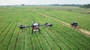
Drone-Based Nutrient Deficiency Detection in Nigeria.
Nutrient deficiency can reduce crop growth and yield long before the problem becomes obvious across an entire field. Traditional scouting may identify visible symptoms, but by that point some areas may already be significantly affected.
Drone-based nutrient deficiency detection in Nigeria offers another approach. By combining drones with multispectral and red-edge imaging, farmers and agricultural professionals can identify spatial differences in crop condition and investigate areas that may require additional nutrients.
This technology is particularly relevant to nitrogen management, where crop demand can vary considerably across a field.
How Drones Detect Nutrient Stress
A standard drone camera records visible colours, but a multispectral camera captures specific wavelengths that are more difficult to see with the human eye.
These commonly include green, red, red-edge and near-infrared bands. Plants respond differently to these wavelengths depending on their structure, chlorophyll content and physiological condition.
When a crop experiences nutrient stress, these characteristics can change. Multispectral imagery can capture some of these changes and convert them into measurable spatial patterns.
The resulting maps do not automatically identify the exact nutrient deficiency. Instead, they highlight areas where crop responses differ and where further investigation may be required.
Why Red-Edge Imaging Matters
The red-edge region is particularly useful for vegetation analysis because it is sensitive to changes associated with chlorophyll and plant condition.
This makes red-edge-based indices such as NDRE, the Normalized Difference Red Edge Index, useful for monitoring crop nitrogen status and other changes in vegetation condition.
A 2026 study conducted in Oyo State, Nigeria, used a DJI Phantom 4 Multispectral UAV to investigate nitrogen deficiency in maize at different growth stages. The researchers found that NDRE showed the strongest correlation with leaf nitrogen content among the indices examined, demonstrating the potential of UAV multispectral imagery for early nitrogen-deficiency detection.
NDVI, NDRE and GNDVI for Nutrient Monitoring
Different vegetation indices provide different perspectives on crop condition.
NDVI uses red and near-infrared reflectance and is widely used to assess general vegetation vigour. It can help identify areas where crop growth differs across a field.
NDRE replaces the red band with a red-edge band. This can make it particularly useful for assessing chlorophyll-related variation in developed crop canopies and investigating nitrogen status.
GNDVI uses the green band and near-infrared reflectance. It can provide additional information about vegetation condition and chlorophyll-related changes.
Using several indices together can therefore provide a more complete picture than relying on a single vegetation map.
From Nutrient Maps to Fertilizer Management
The main objective is not simply to produce a colourful map. The information needs to support a practical fertilizer decision.
A typical workflow can involve:
- Drone survey: Multispectral imagery is collected across the farm.
- Image processing: The imagery is processed into an orthomosaic and vegetation-index maps.
- Nutrient assessment: NDVI, NDRE, GNDVI and other indicators are examined for spatial patterns associated with crop condition.
- Field verification: Selected areas are inspected and, where appropriate, soil or plant tissue samples are collected.
- Fertilizer planning: Verified nutrient differences can inform targeted fertilizer applications or prescription maps.
- Follow-up monitoring: A second drone survey can assess how crop conditions change after management.
This approach can move fertilizer management away from treating every part of a field identically.
Can Drones Identify Nitrogen Deficiency?
Nitrogen is particularly suitable for remote-sensing analysis because it is closely associated with chlorophyll and plant growth.
However, a drone image cannot independently prove that nitrogen is the cause of a crop’s poor condition. Water stress, disease, pests, soil differences and other factors can create similar spectral patterns.
For that reason, strong nutrient-management workflows combine aerial data with field observations, soil tests, plant measurements and agronomic knowledge.
Research outside Nigeria has also demonstrated the potential of UAV multispectral imagery and NDRE for monitoring nitrogen demand and supporting spatially variable nitrogen management.
Why This Matters for Nigerian Farms
Fertilizer is a significant input for crop production, so applying it where it is needed can be important for both productivity and resource efficiency.
Drone-based monitoring can help identify areas that require closer attention instead of relying entirely on uniform field treatment. This is especially useful for larger farms where inspecting every section manually can be difficult.
Research from Southwest Nigeria has also explored low-cost drone-based multispectral imaging for crop-health monitoring on smallholder farms in Oyo and Ogun States, showing the growing local interest in accessible precision-agriculture technologies.
The Future of Precision Fertilizer Management
The next stage is moving from simple vegetation maps to integrated decision-support systems. Multispectral imagery can be combined with soil data, weather information, crop growth stages, GIS and machine learning to produce more detailed nutrient-management recommendations.
Recent research has shown that combining UAV multispectral imagery with other data sources can improve nitrogen-status and nitrogen-use-efficiency estimation, while machine-learning models can help translate spectral information into crop-management indicators.
Geoinfotech provides drone and multispectral agricultural solutions that can support crop monitoring, vegetation-index analysis and precision-agriculture workflows.
For Nigerian farmers and agribusinesses, drone-based nutrient deficiency detection provides a way to identify spatial differences in crop condition earlier, investigate possible nutrient problems and build more targeted fertilizer-management strategies. The strongest results come when drone data is combined with field and agronomic information before fertilizer decisions are made.















































































