

Applications of Remote Sensing in Agriculture. Here’s a fun exercise before we start. Think about the last time you ate a meal. Somewhere behind that plate of food was a farm, and increasingly, that farm was being watched from space.
Not in a sci-fi, invasive way. In a quiet, data-driven way that’s helping farmers grow more food, waste fewer resources, and catch problems before they spiral into disasters. Remote sensing has become one of agriculture’s most powerful allies, and once you see the full range of what it can do, you’ll never look at a satellite image the same way again.
Monitoring Crop Health Before Your Eyes Ever Could
Here’s a question: could you tell if a plant was stressed three days before it started visibly wilting? Probably not. But a satellite can.
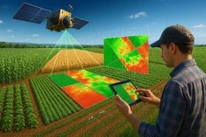
Remote sensing sensors capture light reflected from plants across different wavelengths, including some that are invisible to the human eye. Healthy, vigorous plants reflect near-infrared light differently than stressed or diseased ones. By analyzing this reflection using indices such as NDVI (Normalized Difference Vegetation Index), analysts can detect crop stress days or even weeks before it becomes visible to the naked eye.
Think about that for a second. A farmer walking their field sees a problem only once it’s visible. A satellite can flag it while it’s still invisible. That head start can be the difference between a manageable fix and a lost harvest.
Mapping Soil Moisture and Guiding Irrigation
Water is one of agriculture’s most precious and most wasted resources. Overwater a field, and you risk root rot and nutrient runoff. Underwater it, and yields suffer. The challenge has always been knowing exactly how much water each part of a field actually needs.
Remote sensing, particularly using microwave and thermal sensors, can measure soil moisture levels across entire fields. Combined with weather data, this allows farmers to build precise irrigation schedules, watering only where and when it’s genuinely needed.
Quick thought: globally, agriculture accounts for roughly 70 percent of freshwater use. Even small improvements in irrigation precision, multiplied across millions of farms, add up to an enormous amount of water saved.
Forecasting Yield Before Harvest Even Begins
Imagine knowing, weeks in advance, roughly how much a field is going to yield. That’s not guesswork anymore. It’s a legitimate application of remote sensing.
By tracking vegetation indices over the course of a growing season and comparing them against historical patterns, analysts can generate surprisingly accurate yield forecasts. This matters enormously for food security planning, market pricing, and helping farmers and buyers make informed decisions long before the harvest actually happens.
Here’s a question worth sitting with: If entire governments and grain markets can plan months based on satellite-derived forecasts, what does that tell you about how much power is packed into a single pixel of satellite imagery?
Detecting Pests and Disease Outbreaks Early
Pests and disease can devastate a farm in a matter of days, and by the time visible damage spreads, it’s often too late to fully contain it. Remote sensing helps catch these threats earlier by detecting the subtle changes in plant reflectance that occur when a crop comes under biological stress, often before a human scout would notice anything unusual.
Combined with drone imagery for closer inspection, this creates an early warning system that lets farmers target treatment to specific problem areas instead of spraying an entire field defensively.
Tracking Land Use and Farmland Expansion
Zoom out even further, and remote sensing becomes a tool for understanding entire agricultural regions. Governments and researchers use satellite imagery over time to track how farmland is expanding or shrinking, monitor deforestation linked to agricultural clearing, and assess whether land is being used sustainably.
This kind of long-term monitoring is nearly impossible to do accurately on the ground at scale. But from space, changes across thousands of square kilometers can be tracked year over year with remarkable consistency.
Supporting Precision Application of Fertilizer and Pesticide
Remember the old approach of treating an entire field the same way, regardless of what each section actually needs? Remote sensing helped end that. By identifying exactly which zones are nutrient deficient or pest-affected, farmers can apply fertilizer and pesticide only where necessary, a practice known as variable rate application.
The result is less waste, lower costs, and importantly, less chemical runoff into surrounding ecosystems.
Assessing Drought and Climate Risk
As climate patterns become less predictable, the ability to monitor drought conditions across large regions in near real time has become critical. Remote sensing tracks vegetation stress, soil moisture, and land surface temperature to flag drought risk early, giving farmers and agricultural agencies time to respond, whether that means adjusting planting schedules, securing water resources, or preparing for potential crop losses.
One last question before we wrap up: if a single technology can help predict yield, catch disease early, save water, and flag drought risk, all from a device that never physically touches the ground, what do you think agriculture will look like a decade from now, once these tools become standard practice everywhere?
Final Thoughts
From spotting invisible plant stress to forecasting harvests before they happen, remote sensing has quietly become one of agriculture’s most valuable tools. It doesn’t replace the farmer’s knowledge or instinct. It sharpens it, giving eyes to what would otherwise stay hidden until it was too late. As access to satellite and drone data continues to expand, these applications are moving from cutting-edge research to everyday farming practice, and that shift is only just getting started.















































































