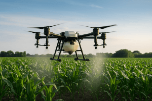
The drone spraying cost in Nigeria depends on several factors. Farm size, crop type, terrain, application requirements and the number of spraying missions can all affect the final price.
Unlike a simple equipment rental, agricultural drone spraying involves planning, transport, trained operators, batteries, product handling and field operations.
Therefore, there is no single price that applies to every farm.
A small farm may require one simple spraying mission. A large commercial farm may need repeated applications throughout the growing season.
This guide explains what affects drone spraying prices in Nigeria. It also shows what farmers should look for when requesting a quotation.
What Determines Drone Spraying Cost in Nigeria?
Several factors influence the price of an agricultural drone spraying service.
The most important factor is usually the size of the area that needs treatment. However, acreage alone does not determine the final cost.
Operators also consider the crop, terrain, location, product and application requirements.
Farm Size
Larger farms generally require more flight time.
They may also require more battery cycles, product refills and field preparation.
A 5-hectare farm will not necessarily cost the same as a 50-hectare farm on a per-hectare basis.
Large projects may benefit from better pricing per hectare because mobilisation and setup costs can be spread across a larger area.
Crop Type
The crop can also affect the cost of drone spraying.
Rice, maize, cassava and cocoa have different field conditions and application requirements.
For example, a large open rice field may allow straightforward flight planning.
A cocoa plantation can require more careful planning because of trees, canopy structure and obstacles.
Therefore, the operator should assess the crop before providing a final quotation.
Location of the Farm
Farm location can affect the total project cost.
A farm close to the service provider may require less travel time and transport expense.
Remote farms may require additional mobilisation.
Road access can also matter. Difficult access may increase the time required to move equipment and personnel to the site.
Terrain and Obstacles
Flat and open fields are usually easier to plan.
However, farms with slopes, trees, buildings, power lines or other obstacles require more detailed planning.
The operator may need to adjust flight routes and operating height.
As a result, terrain can affect both the time and complexity of the mission.
Is Drone Spraying Charged Per Hectare?
Many agricultural drone spraying services can be priced according to the area treated.
A per-hectare model makes it easier for farmers to estimate the basic spraying cost.
However, the final quotation may include other charges.
These can include mobilisation, difficult terrain, remote locations, minimum service charges and additional field operations.
For this reason, farmers should ask whether a quoted per-hectare price covers the complete service.
A low price per hectare may not always represent the full project cost if important services are excluded.
What Is Usually Included in a Drone Spraying Quote?
A professional quotation should clearly explain what the farmer is paying for.
The service may include:
- Drone and spraying equipment
- Trained drone operator
- Flight planning
- Field mobilisation
- Batteries and charging
- Water or product mixing support where applicable
- Actual spraying operation
- Basic mission records
- Equipment transport
However, not every provider includes the same services.
Therefore, farmers should request a clear breakdown before approving the work.
Does the Chemical Cost Come With Drone Spraying?
Not always.
Some service providers charge for the drone application only. The farmer supplies the approved agricultural product.
Other arrangements may include product handling as part of the project.
Farmers should confirm this before accepting a quotation.
The product itself can represent a significant part of the total farm treatment cost.
More importantly, operators should use products according to their approved labels and application instructions.
Drone Spraying Cost for Small Farms
Small farms may need only occasional spraying.
For these farms, the service price can depend heavily on mobilisation and minimum project charges.
For example, a small farm located far from the service provider may have higher total costs than a larger farm located closer to the operator.
Therefore, farmers should provide accurate information when requesting a quote.
Useful details include farm size, location, crop type and the number of expected applications.
Drone Spraying Cost for Large Farms
Large farms usually have different pricing considerations.
A commercial farm may require several spraying missions during one growing season.
In that situation, a service provider may prepare a recurring service arrangement.
Repeated missions can make planning easier for both the farm and the operator.
The provider can also plan equipment, batteries, operators and travel requirements in advance.
For large agricultural operations, farmers should ask whether a seasonal or multi-mission agreement is available.
Rice Farm Drone Spraying Cost
Rice farms are a common application for agricultural spraying drones.
Large rice fields can benefit from aerial application because the drone can operate above wet or difficult ground.
The final cost depends on the total area, field access, product and number of applications.
Repeated spraying can also change the overall project price.
Farm managers should therefore request a quotation based on the full treatment program rather than only one mission.
Internal link: Link agricultural drone spraying for rice farms to your existing crop-by-crop agricultural drone spraying article.
Maize Farm Drone Spraying Cost
Maize farms can also use drones for crop protection and suitable nutrient applications.
As maize grows taller, walking through the field can become more difficult.
Drone application can reduce the need for workers to move between crop rows.
The cost depends on field size, crop condition, location and application requirements.
Farmers should also specify whether they need one treatment or several applications during the season.
Cassava Farm Drone Spraying Cost
Cassava farms can cover large areas.
Some farms may also have uneven terrain or difficult access.
These conditions can affect flight planning and mobilisation.
The provider may need additional time to inspect the farm and plan safe flight routes.
Therefore, farmers should provide the exact farm location and approximate acreage when requesting a quote.
Cocoa Farm Drone Spraying Cost
Cocoa farms can require more detailed flight planning.
Trees, canopy height and plantation layout can affect drone operations.
The operator must consider these factors before beginning the mission.
As a result, cocoa spraying may not have the same pricing structure as spraying a flat, open field.
Farm condition and accessibility should be included when requesting a quotation.
Drone Fertilizer and Foliar Spraying Cost
Agricultural drones can also apply suitable fertilizers and foliar nutrients.
The cost can depend on the product, application rate and area.
The number of applications can also affect the total project cost.
Some farms may combine fertilizer application with crop monitoring.
Internal link: Link drone fertilizer spraying in Nigeria to your existing article on drone fertilizer and foliar nutrient spraying.
Does Drone Spraying Cost More Than Manual Spraying?
The answer depends on the complete operation.
Manual spraying may have lower equipment costs. However, large farms can require many workers and significant labour time.
Drone spraying introduces equipment and operator costs.
At the same time, it can reduce the need for workers to carry spraying equipment across the field.
It can also provide faster access to large or difficult areas.
Therefore, farmers should compare the total cost of completing the job rather than comparing only the price of one spraying method.
Drone Spraying Cost vs Buying a Spraying Drone
Farmers have two main options.
They can hire a professional drone spraying service. Alternatively, large agricultural businesses may consider purchasing their own equipment.
Buying a drone involves more than the aircraft purchase price.
The farm may also need:
- Trained operators
- Batteries
- Charging equipment
- Spare parts
- Maintenance
- Software
- Storage
- Insurance or other operational costs
- Regulatory compliance
- Training and safety procedures
The farm must also keep the equipment operational throughout the season.
For occasional spraying, hiring a service can avoid many of these ownership responsibilities.
For farms with frequent spraying requirements, ownership may require a separate cost analysis.
What Can Increase Drone Spraying Prices?
Several conditions can increase the final quotation.
Remote Farm Location
Long-distance travel can increase mobilisation costs.
Difficult Terrain
Slopes, trees and obstacles can increase flight planning time.
Small Treatment Area
A small farm may still require transport and equipment setup.
Multiple Products
Different products may require additional preparation or separate applications.
Multiple Missions
Repeated visits increase the total project cost.
Crop Monitoring
Adding mapping or crop monitoring creates additional work and deliverables.
Difficult Weather
Poor weather can delay a mission.
If the operator must return to the farm later, additional mobilisation may affect the project cost.
How to Get an Accurate Drone Spraying Quote
Farmers can get better quotations by providing complete information.
Start with the farm location.
Next, provide the total area in hectares.
Then specify the crop and the intended application.
The farmer should also state whether the product will be supplied by the farm or service provider.
Finally, explain whether the job is a one-time mission or part of a repeated spraying program.
This information allows the operator to estimate the project more accurately.
Questions to Ask Before Hiring a Drone Spraying Company
Before choosing a service provider, ask several practical questions.
Is the operator trained?
Ask who will operate the drone and whether the operator has relevant experience.
What drone will be used?
Different agricultural drones have different tank sizes, flight capabilities and spraying systems.
Is the quotation per hectare?
Confirm whether the price is based on area or another pricing method.
Does mobilisation cost extra?
Ask whether transport to the farm is included.
Are chemicals included?
Confirm whether the farm supplies the product.
How many applications are included?
A single spraying mission is different from a seasonal program.
What happens if weather stops the mission?
Ask how rescheduling is handled.
Are records provided?
For commercial farms, mission records can be useful for farm management.
Drone Spraying and Regulatory Requirements in Nigeria
Commercial drone operations in Nigeria are subject to aviation requirements.
The Nigerian Civil Aviation Authority states that Part 21 covers certification, registration, operations and surveillance of remotely piloted aircraft systems. The NCAA also provides a dedicated RPAS portal for registration and approval processes.
The NCAA’s current information also identifies certification requirements for organizations conducting commercial RPAS operations in Nigeria.
Outbound link: Link NCAA RPAS requirements to the official NCAA RPAS portal.
Farmers should therefore confirm that the service provider follows the applicable aviation requirements before starting a commercial operation.
Agricultural chemical use must also follow the applicable product requirements and safety instructions.
Why Cheap Drone Spraying May Not Always Be the Right Comparison
Price is important, but farmers should look beyond the headline figure.
A very low quotation may exclude important services.
For example, the price may not include mobilisation, additional missions or difficult terrain.
The provider may also use different equipment or service conditions.
Therefore, farmers should compare complete quotations.
The better question is not simply, “How much does drone spraying cost?”
Instead, ask:
“What exactly is included in the drone spraying price?”
This gives farmers a clearer basis for comparing providers.
Can Drone Spraying Reduce Farm Labour Requirements?
Drone spraying can reduce the need for workers to walk through fields carrying spraying equipment.
This can be useful on large farms.
However, drone spraying does not eliminate the need for farm workers.
Operators are still required to plan and conduct the mission.
Farm teams may also handle product preparation, field inspection and other agricultural tasks.
Therefore, the main benefit is a change in how spraying work is performed.
Combining Drone Spraying With Drone Mapping
Farmers can combine spraying with other drone services.
For example, a farm can first be mapped using aerial imagery.
The resulting data can support field planning and management.
The same farm can then use agricultural drones for spraying.
This creates a more connected workflow.
Internal link: Link drone mapping in Nigeria to your existing Drone Mapping in Nigeria article.
Combining Spraying With Crop Monitoring
Crop monitoring can add another layer of information.
A farm may use multispectral imagery to identify areas with differences in vegetation response.
The farm team can then inspect those areas before deciding on a treatment.
After spraying, another monitoring flight can help track field conditions.
This approach can support precision agriculture.
However, imagery should complement field inspection and professional agronomic advice.
Geoinfotech Agricultural Drone Spraying Services
Geoinfotech provides drone and geospatial services for agricultural applications in Nigeria.
The company supports agricultural drone operations alongside mapping and crop monitoring services.
Its agricultural work has included rice farms in Kebbi and Benue and a 60-hectare farming operation in Kano.
The company also uses agricultural drone technology such as the DJI Agras T50 for suitable spraying operations.
Farmers can combine spraying with mapping and monitoring when their project requires a wider precision agriculture workflow.
Getting a Drone Spraying Quote From Geoinfotech
The easiest way to receive an accurate quotation is to provide the basic project details.
These should include:
- Farm location
- Farm size in hectares
- Crop type
- Target application
- Number of expected treatments
- Whether the farmer supplies the product
- Site access conditions
- Whether mapping or monitoring is required
With this information, the service provider can assess the project and prepare a suitable quotation.
Final Thoughts on Drone Spraying Cost in Nigeria
The drone spraying cost in Nigeria depends on the project.
Farm size is important, but it is not the only factor.
Crop type, location, terrain, application requirements, mobilisation and the number of missions can all affect the final price.
For this reason, farmers should avoid choosing a service based only on the lowest advertised rate.
Instead, compare the complete service.
Ask what equipment, operators, transport, flight planning and spraying work are included.
For large farms, also consider repeated missions and seasonal service arrangements.
When properly planned, agricultural drone spraying can provide a practical way to manage crop applications across Nigerian farms.