Document

Where to Buy the DJI FlightHub 2 in Lagos, Nigeria

Quick Summary

Looking for where to buy the DJI FlightHub 2 in Lagos, Nigeria? This guide explains the features, applications, benefits, and how organizations in Nigeria can access DJI FlightHub 2 for enterprise drone operations, remote mission management, mapping, and real-time aerial coordination.

Introduction

Search trends for:

  • Where to buy the DJI FlightHub 2 in Lagos
  • Where to buy the DJI FlightHub 2 in Nigeria
  • DJI FlightHub 2 price in Nigeria
  • How to get the DJI FlightHub 2 in Lagos
  • DJI enterprise drone software Nigeria

are increasing rapidly as more industries adopt drone technology for inspections, mapping, surveillance, construction monitoring, and emergency response.

As drone operations continue to scale across Nigeria, businesses require a centralized platform for mission planning, live drone management, cloud mapping, and team collaboration. DJI FlightHub 2 provides an advanced cloud-based solution designed specifically for enterprise drone operations.

GeoStore offers access to authentic DJI enterprise solutions, helping organizations across Nigeria streamline drone workflows with professional support and deployment guidance.

Overview of DJI FlightHub 2

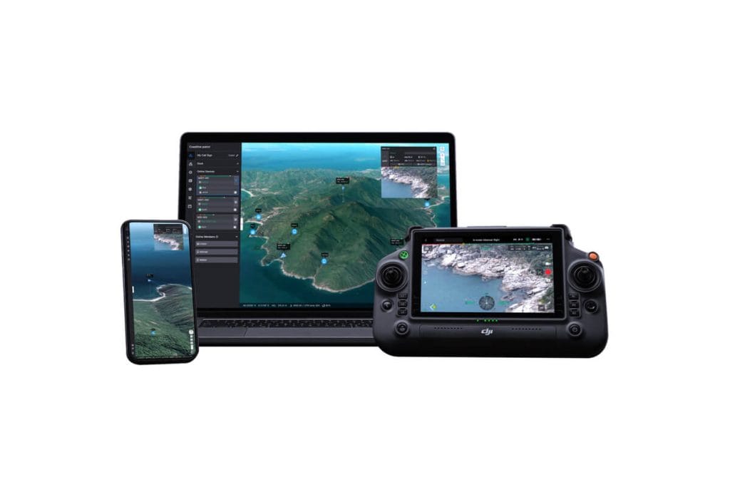
DJI FlightHub 2 is a cloud-based drone operations management platform developed by DJI for enterprise users.

The platform enables organizations to:

  • Manage drone fleets remotely
  • Monitor live drone missions
  • Share real-time aerial data
  • Coordinate teams from a centralized dashboard
  • Create cloud-based mapping projects
  • Improve operational efficiency and safety

DJI FlightHub 2 is designed for industries that require accurate aerial intelligence and collaborative field operations.

Key Features of DJI FlightHub 2

A professional DJI FlightHub 2 setup includes several advanced operational features:

Real-Time Mission Management

Operators can:

  • Monitor live drone feeds
  • Track aircraft status remotely
  • Coordinate multiple missions simultaneously
  • Communicate with field teams in real time

Cloud Mapping & Data Sharing

The platform supports:

  • Orthomosaic map generation
  • Cloud-based project storage
  • Annotation and measurement tools
  • Team collaboration across locations

Fleet & Device Management

Organizations can manage:

  • Multiple drone fleets
  • Pilot accounts
  • Flight logs
  • Device health and operational status

Remote Operations Capability

DJI FlightHub 2 supports remote operational awareness, making it suitable for:

  • Large-scale infrastructure inspections
  • Industrial monitoring
  • Security operations
  • Emergency response coordination

Industries That Use DJI FlightHub 2

Surveying & Mapping

Surveyors use DJI FlightHub 2 to:

  • Manage aerial mapping projects
  • Share geospatial data
  • Monitor survey progress remotely

Construction & Infrastructure

Construction companies benefit from:

  • Site progress monitoring
  • Earthwork analysis
  • Asset inspection workflows
  • Project documentation

Oil & Gas Operations

The platform supports:

  • Pipeline inspections
  • Facility monitoring
  • Hazard assessment
  • Remote operational coordination

Public Safety & Emergency Response

Emergency teams use DJI FlightHub 2 for:

  • Search and rescue
  • Disaster monitoring
  • Incident coordination
  • Live situational awareness

Agriculture & Environmental Monitoring

Agricultural and environmental organizations use the platform for:

  • Crop monitoring
  • Land analysis
  • Wetland observation
  • Environmental assessment

Benefits of DJI FlightHub 2

Organizations adopting DJI FlightHub 2 gain:

  • Centralized drone management
  • Improved operational efficiency
  • Faster decision-making
  • Enhanced team collaboration
  • Secure cloud-based access
  • Better aerial data organization
  • Reduced operational downtime

Its enterprise-grade ecosystem makes it ideal for organizations scaling drone operations across multiple locations in Nigeria.

Where to Buy DJI FlightHub 2 in Lagos, Nigeria

If you are searching for:

  • Where to buy the DJI FlightHub 2 in Lagos
  • Where to buy DJI enterprise software in Nigeria
  • DJI FlightHub 2 provider near me
  • DJI drone management software Nigeria

GeoStore provides:

  • Access to authentic DJI enterprise solutions
  • Professional consultation and setup guidance
  • Enterprise drone workflow support
  • Nationwide delivery across Nigeria
  • Technical assistance for deployment and integration

Businesses and government organizations can obtain DJI FlightHub 2 solutions tailored to operational requirements and industry-specific applications.

How to Get DJI FlightHub 2 in Nigeria

GeoStore simplifies the process of acquiring DJI enterprise software solutions.

Instead of navigating complex enterprise procurement channels, organizations can access:

  • Verified DJI enterprise products
  • Deployment support
  • Enterprise consultation
  • Compatible drone ecosystem recommendations
  • Ongoing technical guidance

This helps businesses deploy drone operations faster and more efficiently.

Compatible DJI Enterprise Ecosystem

DJI FlightHub 2 integrates effectively with several DJI enterprise drone solutions, including:

  • DJI Matrice 400
  • DJI Matrice 4T
  • DJI Mavic 3 Enterprise
  • DJI Mavic 3 Multispectra. These systems work together to improve aerial intelligence, operational coordination, and enterprise data management.

Related Drone & Mapping Solutions

To maximize your drone operations, you may also need:

  • Where to buy a drone in Nigeria
  • Where to buy RTK GPS in Nigeria
  • Where to buy GIS software in Nigeria
  • Where to buy surveying equipment in Lagos
  • Where to buy drone batteries in Nigeria

These tools improve aerial accuracy, operational efficiency, and geospatial data collection.

Conclusion

If you are looking for where to buy the DJI FlightHub 2 in Lagos, Nigeria, GeoStore remains a trusted source for enterprise drone solutions and professional geospatial technologies.

Whether your organization operates in surveying, construction, oil & gas, public safety, agriculture, or infrastructure management, DJI FlightHub 2 provides a powerful cloud-based platform for managing modern drone operations efficiently and securely.

With the right deployment strategy and enterprise support, organizations can improve collaboration, enhance aerial intelligence, and scale drone operations across Nigeria.

FAQs

What is DJI FlightHub 2?

DJI FlightHub 2 is a cloud-based enterprise drone management platform designed for mission planning, live operations monitoring, mapping, and fleet management.

Who uses DJI FlightHub 2?

Industries including surveying, construction, oil & gas, agriculture, security, and emergency response use the platform for drone operations management.

Can DJI FlightHub 2 support remote drone operations?

Yes. The platform enables remote mission monitoring, team collaboration, and real-time operational awareness.

Is DJI FlightHub 2 suitable for enterprise drone fleets?

Yes. It is specifically designed for managing multiple drones, pilots, projects, and operational workflows.

Where can I buy the DJI FlightHub 2 in Lagos, Nigeria?

GeoStore provides access to DJI FlightHub 2 and other DJI enterprise drone solutions for organizations across Nigeria.

RECENT ACTIVITIES AND PROJECT...

URABN HEAT ISLAND EFFECT IN CALABAR MUNICIPAL

URABN HEAT ISLAND EFFECT IN CALABAR MUNICIPAL

ANALYZING URBANIZATION TRENDS IN KANO STATE, NIGERIA USING NIGHTTIME LIGHTS REMOTE SENSING DATA

ANALYZING URBANIZATION TRENDS IN KANO STATE, NIGERIA USING NIGHTTIME LIGHTS REMOTE SENSING DATA

COMPREHENSIVE OFFSHORE SURVEILLANCE AND MARITIME INFRASTRUCTURE MONITORING

COMPREHENSIVE OFFSHORE SURVEILLANCE AND MARITIME INFRASTRUCTURE MONITORING

Comprehensive Aerial Survey and Mapping for Golf Course Asset Management at Lakowe Golf Lake

Comprehensive Aerial Survey and Mapping for Golf Course Asset Management at Lakowe Golf Lake

Professional Drone Training Program for Enhanced Corporate Security Operations at Sahara Group

Professional Drone Training Program for Enhanced Corporate Security Operations at Sahara Group

Advanced Aerial Topographic Survey and Mapping for Land Development in Ogun State

Advanced Aerial Topographic Survey and Mapping for Land Development in Ogun State

Precision RGB and Thermal Imaging Revolutionizes Solar Infrastructure Inspection In Enugu

Precision RGB and Thermal Imaging Revolutionizes Solar Infrastructure Inspection In Enugu

Advanced Drone-Based Topographic Survey for Precision Land Development Planning

Advanced Drone-Based Topographic Survey for Precision Land Development Planning

Mapping the Future: Comprehensive Area Survey Transforms Land Development in Akure

Mapping the Future: Comprehensive Area Survey Transforms Land Development in Akure

Precision Topographical Survey and Mapping for Smarter Infrastructure Planning

Precision Topographical Survey and Mapping for Smarter Infrastructure Planning

Precision Drone Volumetric Surveys: How Purechem Industries Optimized Mineral Stockpile Management

Precision Drone Volumetric Surveys: How Purechem Industries Optimized Mineral Stockpile Management

Advanced Mapping & Environmental Survey for Ilubirin Property, Lagos Island

Advanced Mapping & Environmental Survey for Ilubirin Property, Lagos Island

Unveiling the Invisible: LiDAR Technology Transforms Terrain Analysis in Abeokuta North

Unveiling the Invisible: LiDAR Technology Transforms Terrain Analysis in Abeokuta North

 DETAILED AERIAL, LAND SURVEY AND GIS ANALYSIS FOR ADVANCED REAL ESTATE DEVELOPMENT

 DETAILED AERIAL, LAND SURVEY AND GIS ANALYSIS FOR ADVANCED REAL ESTATE DEVELOPMENT

Professional Drone Mapping and GIS Training For ETA-ZUMA Mining Company

Professional Drone Mapping and GIS Training For ETA-ZUMA Mining Company

Installation of Intelligent Traffic Lights

Installation of Intelligent Traffic Lights

Geological Report on a Mining/Exploration Survey

Geological Report on a Mining/Exploration Survey

Drone Survey and Mapping of Shaishen Foods Limited

Drone Survey and Mapping of Shaishen Foods Limited

Lidar Topographic Mapping Project

Lidar Topographic Mapping Project

Geophysical/hydrogeophysical Studies for Groundwater Development

Geophysical/hydrogeophysical Studies for Groundwater Development

Togo Digital Terrain Model Project

Togo Digital Terrain Model Project

Drone Mapping of Parts of Lome Rail Line for Graceland Energy Located at Lome Togo

Drone Mapping of Parts of Lome Rail Line for Graceland Energy Located at Lome Togo

Drone/land Survey of Pure-chem Industrial Limited, Ogun State.

Drone/land Survey of Pure-chem Industrial Limited, Ogun State.

Drone Inspection/survey of Southern Lake Estate, Chevron, Lekki, Lagos State

Drone Inspection/survey of Southern Lake Estate, Chevron, Lekki, Lagos State

Anniversary-Workshop on the Application of Remote Sensing and Drone Technology in GIS -Abuja

Anniversary-Workshop on the Application of Remote Sensing and Drone Technology in GIS -Abuja

Topographic Mapping of Oyo State

Topographic Mapping of Oyo State

Topographic Mapping of Part of the Local Government Areas in Oyo State

Topographic Mapping of Part of the Local Government Areas in Oyo State

Topographic Mapping of Part of Kwara, Ekiti and Kogi State Local Government Area

Topographic Mapping of Part of Kwara, Ekiti and Kogi State Local Government Area

Political Map of South West, Nigeria Located in Nigeria

Political Map of South West, Nigeria Located in Nigeria

Topographic Mapping of Parts of Niger State Located at Niger State, Nigeria

Topographic Mapping of Parts of Niger State Located at Niger State, Nigeria

Topographic Mapping of Part of Kwara, Ekiti, and Kogi State Local Government Area Located in Nigeria

Topographic Mapping of Part of Kwara, Ekiti, and Kogi State Local Government Area Located in Nigeria

Topographic Mapping of Part of Kwara State Local Government Area Located at Kwara State Nigeria

Topographic Mapping of Part of Kwara State Local Government Area Located at Kwara State Nigeria

Flood Analysis of Amuwo-odofin Orthophoto.

Flood Analysis of Amuwo-odofin Orthophoto.

Site Inspection Using Drone of Water Corporation Located at Oke-aro Agege

Site Inspection Using Drone of Water Corporation Located at Oke-aro Agege

24,000 meter Lome Rail Line for Drone Mapping, Graceland Energy Located at Lome, Togo

24,000 meter Lome Rail Line for Drone Mapping, Graceland Energy Located at Lome, Togo

10 Drone Inspection Traffic Signal in Lagos

10 Drone Inspection Traffic Signal in Lagos

Lagos October 1st Free GIS Training Workshop

Lagos October 1st Free GIS Training Workshop

Osun state parcel project

Osun state parcel project

Drone Mapping & Vectorization Of Abu-allied Farm

Drone Mapping & Vectorization Of Abu-allied Farm

Proposal for aerial deployment, tracking and monitoring of threats in victoria island phase 1 and ikoyi phase 2, nigeria

Proposal for aerial deployment, tracking and monitoring of threats in victoria island phase 1 and ikoyi phase 2, nigeria

Jabi Lake Mall Solar Inspection – Abuja

Jabi Lake Mall Solar Inspection – Abuja

Ground Control and Drone Survey for Mast 3D Modeling

Ground Control and Drone Survey for Mast 3D Modeling

Telecom Drone 3D and 2D Modeling of Cellsite

Telecom Drone 3D and 2D Modeling of Cellsite

Free GIS Spatial Analysis Training (Lagos Branch)

Free GIS Spatial Analysis Training (Lagos Branch)

800 Building Plots Aerial Capture and Delineation for Database. Greenfield Estate

800 Building Plots Aerial Capture and Delineation for Database. Greenfield Estate

100 Hectares Aerial Survey with Differential GPS of High Accuracy

100 Hectares Aerial Survey with Differential GPS of High Accuracy

Protected: Nigeria Crime Report and Dashboard

Protected: Nigeria Crime Report and Dashboard

Drone Survey and Mapping – Victoria Island  Copy

Drone Survey and Mapping – Victoria Island Copy

Akwa-Ibom 500 Hectares Drone Survey and Mapping in Nigeria

Akwa-Ibom 500 Hectares Drone Survey and Mapping in Nigeria

Ground Control Establishment – Republic of the Niger – Kano, Kastina, Jigawa, Kaduna

Ground Control Establishment – Republic of the Niger – Kano, Kastina, Jigawa, Kaduna

Drone Survey and Mapping – Victoria Island

Drone Survey and Mapping – Victoria Island

Control Point Establishment – DGPS

Control Point Establishment – DGPS

Land Survey – Northern Nigeria

Land Survey – Northern Nigeria

Biodiversity Mapping – Sweden

Biodiversity Mapping – Sweden

Flood Impact Mapping – United Kingdom

Flood Impact Mapping – United Kingdom

M and E GIS Dashboard for Control Establishment Project

M and E GIS Dashboard for Control Establishment Project

Geodatabase Management System Training For National Boundary Commission

Geodatabase Management System Training For National Boundary Commission

Nigeria Topographic Map – Project

Nigeria Topographic Map – Project

Abuja Training on Introduction to GIS

Abuja Training on Introduction to GIS

200 Hectares Land and Drone Survey – Lagos Nigeria

200 Hectares Land and Drone Survey – Lagos Nigeria

Inspection of 30 hectares drainage

Inspection of 30 hectares drainage

Drainage Drone Mapping and Surveying in Lagos Nigeria

Drainage Drone Mapping and Surveying in Lagos Nigeria

GIS Cadastral Mobile Application

GIS Cadastral Mobile Application

Abuja Topographical Map – HD GIS Mapping

Abuja Topographical Map – HD GIS Mapping

Ground Topography Survey (Lagos Island)

Ground Topography Survey (Lagos Island)

2.7km2 Topography Survey in Snake Island

2.7km2 Topography Survey in Snake Island

GIS Masterclass

GIS Masterclass

Sokoto Contour Map

Sokoto Contour Map

NDVI Vegetation Assessment in Lagos State

NDVI Vegetation Assessment in Lagos State

Lagos drone training master class

Lagos drone training master class

Ifako drone topographic survey and mapping

Ifako drone topographic survey and mapping

CMD Lagos 3D mapping aerial modeling

CMD Lagos 3D mapping aerial modeling

GIS and Drone Masterclass

GIS and Drone Masterclass

Drone aerial survey and mapping – Lagos Island _ Somolu

Drone aerial survey and mapping – Lagos Island _ Somolu

Covid-19 | Nigeria Data Visualisation

Covid-19 | Nigeria Data Visualisation

Benue Flood Analysis

Benue Flood Analysis

Aerial photography Ile-Ife Osun State

Aerial photography Ile-Ife Osun State

Kenya Forest Project

Kenya Forest Project

Tunsun Consultants Ltd

Tunsun Consultants Ltd

Introduction To Gis In Maritime at the National Boundary Commission

Introduction To Gis In Maritime at the National Boundary Commission

Training on GIS and Drone Mapping (batch-4 & 5)

Training on GIS and Drone Mapping (batch-4 & 5)

Osun Flood Mapping

Osun Flood Mapping

Lahass International Limited

Lahass International Limited

Linguistic Association of Nigeria

Linguistic Association of Nigeria

West African Indexing Services

West African Indexing Services

Lagos Ikeja Road Network Map

Lagos Ikeja Road Network Map

LASU Land Regularisation Portal

LASU Land Regularisation Portal

Lingua Plus International

Lingua Plus International

Lagferry Web Route

Lagferry Web Route

YOU MAY ALSO LIKE...

COURSES

Explore Geoinfotech courses and establish a strong foundation of knowledge and skills to be productive with the latest Technology.

NYSC Career Acceleration Program

The NYSC Career Acceleration Training Program is designed to equip corps members with industry-relevant geospatial and surveying skills that enhance…

Find out more

2-DAY DRONE PILOT TRAINING FOR YABATECH

This comprehensive 2-day drone pilot training program is designed to provide participants with essential theoretical knowledge and practical hands-on experience…

Find out more

Differential GPS (DGPS) Land Surveying Training

Professional 2 weekends ▪ Field Experience 5.0 (100% Practical) ▪ Exam & CertificateFree Software and AppsHands on Practical and Field…

Find out more

Training on AutoCAD for Surveying and Mapping

Duration: 4 Weekends (Every Friday 2pm and Saturday 10am)
Package: Field Experience, 100% Hands-on practical, jotter, Biro and Software Others, Test, Exam and Certificate.

Find out more
Training Venue Available in,Lagos and Abuja100253Nigeria
+ Google Map