
Picture the scene: you want to understand road risk across Lagos. You do not want a static report. You want to explore the data yourself, click on any road, and get the facts instantly. Our Lagos road risk dashboard gives you exactly that.
You can access the Lagos road risk dashboard right now at obehi1.github.io/lagos-road-risk. No login is required. No software is needed. It works in any modern browser.
The dashboard covers all 20 Lagos local government areas. It analyses 82,992 road segments across 17,997 kilometres of road network. Moreover, every segment is classified by degradation risk so you can see clearly where roads are most vulnerable.
How to Access and Use the Lagos Road Risk Dashboard
First, open the dashboard using the link above. The interface loads a full-screen map of Lagos with all roads coloured by risk class. You will also see two side panels.
Second, choose your area of interest. You can either click directly on the map or use the left panel to find a specific LGA. Either action activates that area and updates all the statistics on the right.
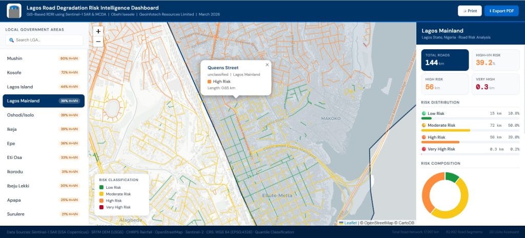
Third, explore the details. Click any road segment on the map to see a popup with the road name, type, LGA, risk class, and length. The right panel then shows the full breakdown for that LGA. You can also print or export what you see at any point.
What Each Panel of the Lagos Road Risk Dashboard Shows
The Lagos road risk dashboard has three panels. Each one serves a different purpose. Together, they give you a complete picture of road risk across Lagos.
Left Panel: LGA List and Search
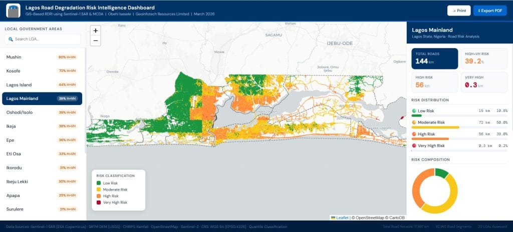
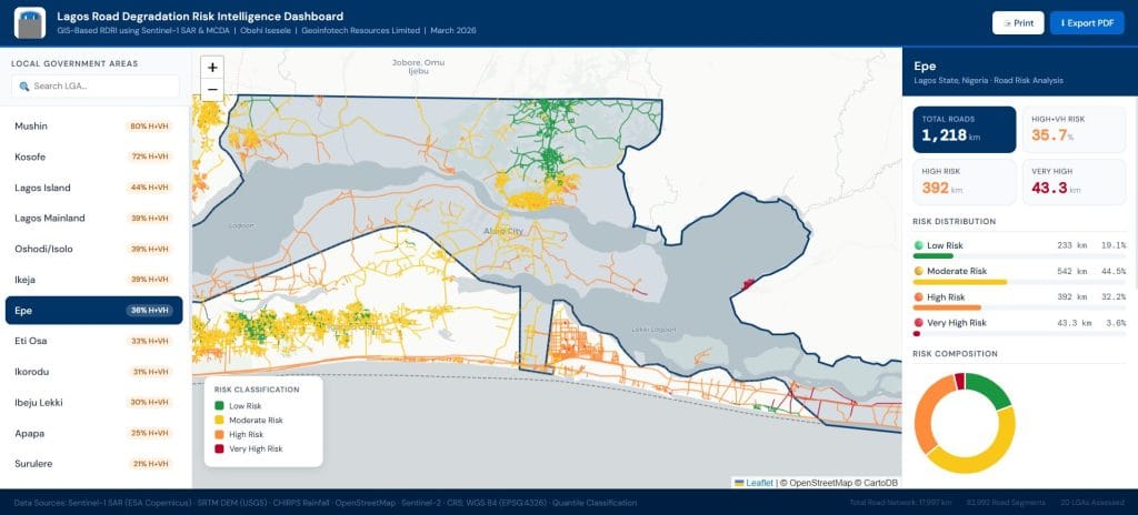
The left panel lists all 20 Lagos LGAs sorted by highest risk first. Shomolu appears at the top because 100 percent of its road network falls in the High or Very High risk category. Mushin is second at 80 percent. Kosofe is third at 72 percent.
A search bar sits above the list. Type any LGA name and the list filters instantly. Furthermore, clicking any LGA name activates it on the map. The centre panel zooms to that area. The right panel updates its statistics to match.
Centre Panel: Interactive Road Network Map
The map shows the full Lagos road network coloured by risk class. Red segments are Very High risk. Orange is High. Yellow is Moderate. Green is Low. LGA boundaries are overlaid so you can see which roads belong to which local government area.
You can interact with the map in two ways. Click any road segment to open a popup. The popup shows the road name, road type, LGA, risk class, and segment length in kilometres. Alternatively, click anywhere inside an LGA boundary. The statistics panel updates instantly and the map zooms to that LGA automatically.
Right Panel: Statistics and Risk Breakdown
The right panel updates every time you click. It shows data for whichever LGA is currently selected. Specifically, the panel displays:
- Total road length in kilometres for the selected LGA
- Combined High and Very High Risk percentage as the headline risk figure
- Risk distribution bars for all four risk classes
- A donut chart showing the full risk composition at a glance
- The dominant risk factor contributing most to degradation in that LGA
- The most vulnerable road corridors flagged for urgent attention
- The MCDA weight table showing how each factor was scored in the analysis
As a result, you can compare any two LGAs in seconds. Simply click one, note the statistics, then click the other. The panel refreshes immediately with the new data.
Print and Export Options in the Lagos Road Risk Dashboard
The Lagos road risk dashboard also supports offline use. A Print button captures the current state of the dashboard. It includes whichever LGA you have selected, the current map view, and all the statistics shown on the right. Your browser handles the print dialog.
An Export PDF button generates an A3 landscape PDF of the current dashboard view. This is useful for presentations, project reports, and briefing documents. Consequently, the dashboard supports both live digital exploration and formal reporting.
Key Findings Behind the Lagos Road Risk Dashboard
The Lagos road risk dashboard is built on months of geospatial research. The study used Sentinel-1 SAR satellite imagery, road network data from OpenStreetMap, and multi-criteria decision analysis to produce a Road Degradation Risk Index for every segment in Lagos.
The findings show that road risk is widespread across the city. Shomolu has the highest proportion of at-risk roads at 100 percent. However, no LGA is free from significant risk. Therefore, the dashboard is useful for infrastructure teams operating anywhere in Lagos, not just in the highest-risk areas.
The risk classification accounts for several factors. These include surface drainage vulnerability, road surface conditions, traffic loading estimates, and proximity to water bodies. The MCDA weight table in the right panel shows exactly how each factor contributed to the final risk score.
Who Should Use the Lagos Road Risk Dashboard
The Lagos road risk dashboard is designed for anyone who needs to understand road infrastructure risk in Lagos. It is particularly useful for:
- State and local government infrastructure teams assessing maintenance priorities
- Transport planning consultants working on Lagos road network projects
- Researchers and academics studying urban infrastructure or satellite-based road monitoring
- Development finance institutions and organisations evaluating road condition for project scoping
- Journalists and policy analysts communicating infrastructure risk to wider audiences
No prior GIS knowledge is required. The dashboard is designed to be intuitive for anyone. Furthermore, no data download or software installation is needed.
Need a Custom GIS Dashboard for Your Organisation?
Geoinfotech Resources Limited builds data-driven geospatial solutions for infrastructure, environment, and planning across Nigeria and beyond. We developed the Lagos road risk dashboard as part of a broader programme of satellite-based road condition research.
If you need road condition analysis, risk mapping, or a custom GIS dashboard for your organisation, our team is ready to help.
Contact us today on 07070708909 or visit geoinfotech.ng to discuss your project.


