
Geoinfotech Drone Pipeline Monitoring in Nigeria: How UAV Inspection Is Replacing Manual Patrol
Nigeria’s pipeline network is one of the largest and most critical in Africa, stretching across the challenging terrain of the Niger Delta creeks, swamps and coastal regions. Maintaining the safety and performance of these pipelines has always been difficult, expensive, and risky.
At Geoinfotech, we provide advanced pipeline monitoring services in Nigeria using drone technology to replace outdated manual patrol methods with faster, safer, and more accurate aerial inspection.
How Drone Technology Is Transforming Pipeline Monitoring in Nigeria
Traditional pipeline patrol methods in Nigeria are slow, hazardous, and inefficient. Field teams must navigate dense mangroves, flooded terrain, and remote areas with limited visibility. Covering long pipeline routes can take days or even weeks.
Drone inspection is changing that.
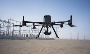
Using industrial-grade UAVs, Geoinfotech can inspect large pipeline corridors in a single day. Our drones fly directly over pipeline right-of-way paths, capturing continuous high-resolution data across the entire corridor.
We deploy multiple advanced sensors, including:
- Thermal imaging sensors to detect temperature anomalies caused by leaks or pressure issues
- Multispectral sensors to identify vegetation stress from hydrocarbon seepage
- LiDAR technology to generate precise 3D terrain models and detect ground movement, erosion, or encroachment
- High-resolution RGB cameras for visual inspection and documentation
This combination allows us to detect pipeline threats early before they become visible on the surface.
Real-Time Data for Faster Decision-Making
One of the biggest advantages of drone pipeline inspection is speed and accuracy.
Our UAV systems deliver georeferenced, real-time data, allowing operators to:
- Identify exact coordinates of leaks or threats
- Eliminate delays from manual reporting
- Access evidence-grade inspection data instantly
- Respond faster to security or maintenance issues
Every anomaly is mapped, recorded, and delivered in a structured format compatible with GIS and asset management systems.
Access Difficult Terrain Without Risk
Drone-based pipeline monitoring eliminates the need for physical access to dangerous locations.
Geoinfotech drones can operate seamlessly across:
- Swamps and mangrove forests
- Offshore and water-based pipeline routes
- Remote and restricted zones
- High-risk areas requiring security escorts
This ensures continuous pipeline surveillance without exposing personnel to danger.
Why Choose Geoinfotech for Pipeline Monitoring Services in Nigeria?
Geoinfotech is a trusted provider of drone pipeline inspection services in Nigeria, delivering reliable results across major pipeline corridors.
What sets us apart:
- Certified drone inspection specialists with proven experience
- Operations across key locations including Lagos, Port Harcourt, Warri, Bayelsa, and Delta State
- Advanced sensor integration (thermal, LiDAR, multispectral, RGB)
- High-quality deliverables including orthomosaic maps, 3D models, and inspection reports
- Expertise serving oil & gas companies, government agencies, and infrastructure operators
- Fast turnaround time with cost-effective inspection solutions
Our drone inspections cover in hours what average patrol teams take days to complete.
Final Takeaway
Pipeline monitoring is no longer just a maintenance task, it is critical for environmental protection, operational efficiency and national security.
Drone-based pipeline inspection provides operators across Nigeria with the visibility needed to detect issues early and act quickly.
Whether you need routine inspection, emergency response, or full pipeline integrity monitoring, Geoinfotech delivers accurate, reliable, and scalable solutions to keep your infrastructure safe and operational.
Frequently Asked Questions
What industries benefit from pipeline monitoring services in Nigeria?
Oil and gas companies, pipeline operators, government agencies, petrochemical facilities, and utility providers all rely on pipeline monitoring for safety and compliance.
How accurate is drone pipeline inspection?
Using RTK-enabled drones, inspections achieve centimetre-level accuracy, enabling precise detection of leaks, encroachments, and structural issues.
Can drones be used beyond oil and gas pipelines?
Yes. Drone inspection is effective for water pipelines, gas distribution systems, and industrial infrastructure.
How long does a pipeline inspection take?
Drone surveys can cover 20–50 km per day, with reports delivered within 48–72 hours.
What deliverables are included?
Clients receive orthomosaic maps, thermal reports, annotated imagery, encroachment alerts, and full pipeline integrity reports compatible with GIS platforms.


