
Drone Mapping vs Satellite Imagery: Which is Better?
Quick Summary
Drone mapping and satellite imagery are two of the most important technologies used in GIS, remote sensing, surveying, and geospatial analysis. While drone mapping delivers ultra-high-resolution data for small areas, satellite imagery provides large-scale Earth observation and continuous regional monitoring. Choosing between drone mapping and satellite imagery depends on factors such as accuracy, project size, budget, data resolution, environmental conditions, and time sensitivity.
Introduction
In the modern geospatial industry, two major technologies dominate spatial data collection: drone mapping and satellite imagery.
Both technologies provide valuable geographic information used across industries, including:
- Urban planning
- Agriculture
- Environmental monitoring
- Construction
- Mining
- Disaster management
- Infrastructure development
- Oil and gas operations
As GIS and remote sensing technologies continue to evolve, many professionals, organizations, and students often ask:
“Which is better: Drone Mapping or Satellite Imagery?”
The answer depends on several important project requirements, such as:
- Accuracy requirements
- Project scale
- Budget
- Data resolution
- Accessibility
- Environmental conditions
- Time sensitivity
Understanding the strengths and limitations of both technologies helps organizations choose the most effective solution for their operational needs.
What is Drone Mapping?
Drone mapping is the process of using Unmanned Aerial Vehicles (UAVs) equipped with cameras or sensors to capture aerial data and generate maps, models, and spatial information.
Drones fly at relatively low altitudes and collect:
- High-resolution images
- Videos
- LiDAR data
- Thermal imagery
- Multispectral imagery
The captured data is processed using photogrammetry or GIS software to generate:
- Orthomosaics
- Digital Elevation Models (DEMs)
- 3D models
- Contour maps
- Point clouds
Drone mapping is widely used for engineering surveys, construction monitoring, precision agriculture, and infrastructure inspection.
What is Satellite Imagery?
Satellite imagery refers to images of the Earth captured by satellites orbiting in space.
These satellites use specialized sensors to detect electromagnetic radiation reflected or emitted from the Earth’s surface.
Satellite imagery may include:
- Optical imagery
- Radar imagery
- Thermal imagery
- Multispectral data
- Hyperspectral imagery
Satellite imagery is commonly used for:
- Large-scale environmental monitoring
- Regional mapping
- Climate studies
- Land use analysis
- Disaster response
- National planning
Unlike drones, satellites can monitor extremely large geographic areas continuously.
Basic Difference Between Drone Mapping and Satellite Imagery
| Drone Mapping | Satellite Imagery |
|---|---|
| Captured by drones/UAVs | Captured by satellites in space |
| Low-altitude data collection | High-altitude orbital data collection |
| Ultra-high spatial resolution | Moderate to high resolution |
| Covers smaller areas | Covers very large areas |
| User-controlled flights | Controlled by satellite operators |
| Suitable for detailed mapping | Suitable for regional monitoring |
| Flexible deployment | Fixed orbital schedules |
How Drone Mapping Works
Drone mapping typically follows several stages:
- Flight planning
- Drone deployment
- Image capture
- GPS positioning
- Data processing
- Map generation
The drone follows predefined flight paths while capturing overlapping images.
Specialized software such as:
- Pix4D
- DroneDeploy
- Agisoft Metashape
- DJI Terra
processes the captured imagery into highly accurate geospatial outputs.
How Satellite Imagery Works
Satellites orbit the Earth continuously while capturing data using onboard sensors.
The workflow typically includes:
- Sensor detection
- Data acquisition
- Data transmission
- Image processing
- Distribution to users
Popular satellite systems include:
- Landsat
- Sentinel
- WorldView
- SPOT
- MODIS
These systems provide continuous global coverage for environmental and geospatial analysis.
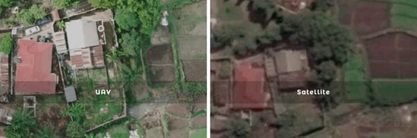
Resolution Comparison: Drone Mapping vs Satellite Imagery
One of the biggest differences between drone mapping and satellite imagery is spatial resolution.
Drone Mapping Resolution
Drone mapping can achieve extremely high resolutions, often between:
- 1 cm/pixel to 5 cm/pixel
This allows users to detect:
- Cracks in infrastructure
- Small vegetation changes
- Surface defects
- Construction details
Satellite Imagery Resolution
Satellite imagery resolution varies by provider:
- Free satellites: 10m–30m resolution
- Commercial satellites: 30cm–50cm resolution
While satellite imagery covers larger areas, it may not provide the detailed accuracy required for engineering-grade surveys.
Accuracy Comparison
Drone Mapping
Drone mapping provides:
- Centimeter-level accuracy
- High-detail surface models
- Precise elevation measurements
Especially when integrated with:
- RTK GPS
- Ground Control Points (GCPs)
Satellite Imagery
Satellite imagery provides:
- Regional-scale accuracy
- Lower positional precision compared to drones
- Reliable long-term monitoring
Satellite imagery is better for macro-level analysis rather than site-specific engineering measurements.
Coverage Area Comparison
Drone Mapping
Drone mapping is best suited for:
- Small-to-medium project sites
- Construction projects
- Local inspections
- Property surveys
However, drone coverage is limited by:
- Battery life
- Flight regulations
- Line-of-sight restrictions
Satellite Imagery
Satellite imagery excels at:
- National mapping
- Continental analysis
- Environmental monitoring
- Climate studies
Satellites can monitor massive geographic areas quickly and efficiently.
Cost Comparison
Drone Mapping Costs
Drone mapping may involve:
- Drone equipment costs
- Pilot training
- Software licensing
- Field operations
- Data processing
Although startup costs may be high, drones become cost-effective for repeated local surveys.
Satellite Imagery Costs
Satellite imagery costs vary:
- Free imagery: Landsat, Sentinel
- Commercial imagery: expensive high-resolution datasets
Satellite imagery is often more affordable for large-area studies.
Time and Accessibility
Drone Mapping
Drone deployment allows:
- Rapid on-demand surveys
- Immediate data collection
- Flexible scheduling
However, operations may be affected by:
- Rain
- Wind
- Flight restrictions
Satellite Imagery
Satellites continuously collect data globally.
However:
- Image availability depends on satellite revisit schedules
- Cloud cover can affect optical imagery
- Some datasets may not be real-time
Drone Mapping vs Satellite Imagery in Smart Cities
Drone Mapping in Smart Cities
Drone mapping is commonly used for:
- Construction monitoring
- Utility inspections
- Traffic analysis
- Infrastructure mapping
- Building inspections
Its high resolution makes it ideal for urban engineering projects.
Satellite Imagery in Smart Cities
Satellite imagery supports:
- Urban expansion analysis
- Regional planning
- Environmental monitoring
- Heat island studies
- Population growth assessment
Satellites provide large-scale urban intelligence for city planners.
When Drone Mapping is Better
Drone mapping is usually better when:
- High accuracy is required
- Small areas need detailed analysis
- Real-time data is necessary
- 3D modeling is important
- Engineering-grade measurements are needed
Typical applications include:
- Construction
- Land surveying
- Mining
- Infrastructure inspection
When Satellite Imagery is Better
Satellite imagery is better when:
- Large areas need monitoring
- Historical imagery is required
- Frequent regional analysis is needed
- Budget is limited
- Remote locations are inaccessible
Typical applications include:
- Climate monitoring
- Agriculture
- Disaster management
- Environmental analysis
Combining Drone Mapping and Satellite Imagery
In many projects, the best solution is to use both technologies together.
A common workflow includes:
- Using satellite imagery for large-scale analysis
- Using drones for detailed site mapping
This integrated approach improves:
- Efficiency
- Accuracy
- Cost-effectiveness
- Decision-making
Future of Geospatial Data Collection
The future of geospatial intelligence increasingly combines:
- Drones
- Satellites
- Artificial Intelligence (AI)
- Cloud computing
- Real-time analytics
Emerging technologies are making spatial data collection:
- Faster
- More accurate
- More automated
- More accessible
Industries across Nigeria and globally are rapidly adopting integrated geospatial solutions for smarter planning and operations.
Conclusion
Drone mapping and satellite imagery are both powerful geospatial technologies, but neither is universally “better.”
The best choice depends on:
- Your project goals
- Required accuracy
- Area coverage
- Budget
- Timeline
Drone mapping delivers ultra-high-resolution data and engineering precision for localized projects, while satellite imagery provides large-scale monitoring and long-term environmental intelligence.
For many organizations, combining both technologies offers the most effective and scalable solution for geospatial analysis and decision-making.
FAQs
What is the main difference between drone mapping and satellite imagery?
Drone mapping uses UAVs for low-altitude, high-resolution data collection, while satellite imagery uses orbiting satellites for large-scale Earth observation.
Which is more accurate: drone mapping or satellite imagery?
Drone mapping generally provides higher spatial accuracy and resolution than satellite imagery.
Is satellite imagery cheaper than drone mapping?
For large-area projects, satellite imagery is often more cost-effective, especially when using free datasets like Landsat or Sentinel.
Can drones replace satellite imagery?
No. Drones and satellites serve different purposes and are often used together in geospatial workflows.
Which is better for GIS projects?
It depends on the project. Drone mapping is ideal for detailed site analysis, while satellite imagery is better for regional and environmental studies.


