
How Satellite Imagery is Collected and Processed
Satellite imagery has transformed the way we understand and monitor the Earth. From tracking climate change and urban expansion to supporting agriculture, disaster management, security, and mapping, satellite images provide valuable information about our planet in near real-time.
However, have you ever wondered how these images are actually captured from space and transformed into the clear maps and visuals we use today?
What is Satellite Imagery?
Satellite imagery refers to pictures or data of the Earth captured by satellites orbiting the planet. These satellites use specialized sensors to detect and record reflected or emitted energy from the Earth’s surface.
Unlike ordinary cameras, satellite sensors can capture information beyond what the human eye can see, including infrared, thermal, and radar signals.
Satellite imagery is widely used in:
- GIS and mapping
- Agriculture
- Environmental monitoring
- Urban planning
- Military intelligence
- Weather forecasting
- Disaster response
- Mining and exploration
- Forestry management
How Satellite Imagery is collected
The image collection process begins when the satellite passes over an area on Earth.
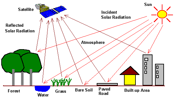
Step 1: Energy Interaction with the Earth
The sun emits electromagnetic energy toward Earth. When this energy reaches the surface, it may:
- Be reflected
- Absorbed
- Transmitted
Different materials reflect energy differently.
For example:
- Healthy vegetation reflects high infrared energy
- Water absorbs most infrared energy
- Urban surfaces reflect differently from forests
These differences help satellites identify surface features.
Step 2: Sensor Detection
The satellite sensor records the reflected or emitted energy.
The data is collected in pixels.
Each pixel contains information about:
- Brightness
- Spectral values
- Temperature
- Surface characteristics
Step 3: Multi-Band Image Capture
Modern satellites capture images in multiple spectral bands.
Common bands include:
- Blue
- Green
- Red
- Near Infrared (NIR)
- Shortwave Infrared (SWIR)
- Thermal Infrared
This allows analysts to detect:
- Plant health
- Soil moisture
- Water bodies
- Heat patterns
- Mineral composition
Step 4: Sensor Detection
The satellite sensor records the reflected or emitted energy.
The data is collected in pixels.
Each pixel contains information about:
- Brightness
- Spectral values
- Temperature
- Surface characteristics
Step 5: Multi-Band Image Capture
Modern satellites capture images in multiple spectral bands.
Common bands include:
- Blue
- Green
- Red
- Near Infrared (NIR)
- Shortwave Infrared (SWIR)
- Thermal Infrared
This allows analysts to detect:
- Plant health
- Soil moisture
- Water bodies
- Heat patterns
- Mineral composition


