Document

DB1560 Battery Nigeria: Why It Keeps Your T50 Flying A Practical Guide to the DJI Agras DB1560 Intelligent Flight Battery for Nigerian Operators

Picture the scene: an operator lands his DJI Agras T50 after the first tank run of the morning. The field is large. The treatment window is narrow. He reaches for the spare battery. There is none. The drone sits on the ground while he arranges sourcing or abandons the session entirely. One missing DB1560 battery in Nigeria does not just cost a few minutes. On a commercial farm, it can cost a harvest. This guide explains what the DB1560 does, why how many you own matters as much as the drone itself, and where to get genuine units in Lagos.

What the DB1560 Actually Is

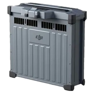
The DB1560 is the official intelligent flight battery for the DJI Agras T50 and T40. It is not a generic rechargeable pack. DJI engineered it specifically around the energy demands of heavy-payload agricultural operations. Furthermore, that distinction matters more than most operators initially appreciate.

The DB1560 carries 30,000 mAh at a nominal voltage of 52.22 volts, delivering 1,567 watt-hours of usable energy per charge. It uses lithium nickel manganese cobalt oxide cells. These cells balance high energy density, thermal stability, and strong discharge performance. As a result, the 11.5C discharge rate means the battery delivers high current even when the T50 carries a full 40-litre spray tank at operational speed.

In addition, an internal battery management system monitors cell voltage, current draw, and temperature in real time. It balances cells automatically across cycles. Furthermore, it protects against short-circuit, over-voltage, over-discharge, and over-temperature events. It also enters self-discharge mode during storage to preserve cell health between seasons.

Flight Time and Field Reality

Field conditions produce 6 to 10 minutes of flight per charge. That figure surprises some operators. However, it reflects the physics of lifting a 40-kilogram spray payload. The good news is that the workflow accounts for it.

On the T50, a full tank and a full battery deplete at roughly the same rate. Therefore, the drone returns not because the battery fails but because the tank needs refilling. The operator refills the tank and swaps the battery at the same moment. Furthermore, the C10000 charging station brings a depleted battery from 30 percent to 95 percent in 9 to 12 minutes. As a result, three batteries in rotation keep the drone in near-continuous operation.

In contrast, compress the battery count to one and a 50-hectare plot stretches across several interrupted days. The battery is not a minor accessory. It sets the entire operational rhythm of the system.

Built for Nigerian Conditions

Agricultural drone operations in Nigeria face genuinely demanding conditions. Therefore, understanding how the DB1560 handles them informs any long-term reliability assessment.

  • Heat management: Nigeria’s temperatures accelerate degradation in standard lithium packs. However, the DB1560 uses advanced heat dissipation technology and an air-cooled heat sink during charging. It operates across ambient conditions from 32 to 140 degrees Celsius.
  • Humidity and dust protection: the battery carries an IP54 rating combined with board-level potting protection. As a result, the electronics resist dust ingress and water splash from any direction during spray operations.
  • Cycle longevity: 1,500 rated charge cycles means the DB1560 suits commercial-intensity use. Furthermore, an operator running three battery rotations daily through a farming season can expect several years of reliable service from a properly maintained pack.
  • Storage behaviour: the DB1560 automatically enters self-discharge mode between seasons. Consequently, this prevents the deep discharge degradation that shortens batteries left fully charged or fully depleted for months.

How Many Batteries Does Your Operation Need?

Geoinfotech asks every operator this question before purchase. The answer directly determines whether an operation runs profitably or loses money to downtime.

Farms up to 30 hectares: two batteries provide adequate rotation if you split treatment sessions across a morning. However, three batteries eliminate any risk of an unplanned gap.

Farms of 30 to 80 hectares: three batteries is the practical minimum for continuous operation. In addition, this is the most common configuration for commercial farmers using the T50 as their primary treatment tool.

Drone service providers treating multiple farms per day: four to six batteries sustain full-day output without forced downtime. As a result, battery count becomes a direct input into daily revenue capacity.

Importantly, operators who start with one battery and plan to expand later consistently report that the gap period is their least productive time in the field. Getting the right count from the outset is therefore a better investment decision than buying more accessories later.

A Note on Genuine vs. Third-Party Batteries

The Nigerian market offers third-party battery units at lower prices than genuine DJI stock. However, the risks are specific. Third-party batteries do not integrate fully with the T50’s battery management system. As a result, the intelligent protections described above may function partially or not at all. A battery fault during flight can result in a drone crash, payload loss, and damage to standing crops.

In contrast, Geoinfotech supplies only genuine DJI DB1560 batteries. Every unit carries the standard DJI warranty of 1,500 cycles or 12 months, whichever comes first. For an asset in commercial agriculture, that assurance is a material part of the product’s value.

Where to Get the DB1560 Battery in Nigeria

Geoinfotech Resources Limited stocks the genuine DB1560 battery in Nigeria and supplies operators across the country from our Lagos base. Whether you buy your first T50 and need the right battery count from the start, expand an existing fleet, or replace a pack that reached end of cycle life, we advise on quantity, configuration, and care.

Reach out to us directly. Discuss your farm size, daily treatment targets, and current battery setup. Above all, getting the power side right is one of the most straightforward ways to improve field productivity without changing anything else.

The drone gets the attention. The battery keeps it flying.

RECENT ACTIVITIES AND PROJECT...

URABN HEAT ISLAND EFFECT IN CALABAR MUNICIPAL

URABN HEAT ISLAND EFFECT IN CALABAR MUNICIPAL

ANALYZING URBANIZATION TRENDS IN KANO STATE, NIGERIA USING NIGHTTIME LIGHTS REMOTE SENSING DATA

ANALYZING URBANIZATION TRENDS IN KANO STATE, NIGERIA USING NIGHTTIME LIGHTS REMOTE SENSING DATA

COMPREHENSIVE OFFSHORE SURVEILLANCE AND MARITIME INFRASTRUCTURE MONITORING

COMPREHENSIVE OFFSHORE SURVEILLANCE AND MARITIME INFRASTRUCTURE MONITORING

Comprehensive Aerial Survey and Mapping for Golf Course Asset Management at Lakowe Golf Lake

Comprehensive Aerial Survey and Mapping for Golf Course Asset Management at Lakowe Golf Lake

Professional Drone Training Program for Enhanced Corporate Security Operations at Sahara Group

Professional Drone Training Program for Enhanced Corporate Security Operations at Sahara Group

Advanced Aerial Topographic Survey and Mapping for Land Development in Ogun State

Advanced Aerial Topographic Survey and Mapping for Land Development in Ogun State

Precision RGB and Thermal Imaging Revolutionizes Solar Infrastructure Inspection In Enugu

Precision RGB and Thermal Imaging Revolutionizes Solar Infrastructure Inspection In Enugu

Advanced Drone-Based Topographic Survey for Precision Land Development Planning

Advanced Drone-Based Topographic Survey for Precision Land Development Planning

Mapping the Future: Comprehensive Area Survey Transforms Land Development in Akure

Mapping the Future: Comprehensive Area Survey Transforms Land Development in Akure

Precision Topographical Survey and Mapping for Smarter Infrastructure Planning

Precision Topographical Survey and Mapping for Smarter Infrastructure Planning

Precision Drone Volumetric Surveys: How Purechem Industries Optimized Mineral Stockpile Management

Precision Drone Volumetric Surveys: How Purechem Industries Optimized Mineral Stockpile Management

Advanced Mapping & Environmental Survey for Ilubirin Property, Lagos Island

Advanced Mapping & Environmental Survey for Ilubirin Property, Lagos Island

Unveiling the Invisible: LiDAR Technology Transforms Terrain Analysis in Abeokuta North

Unveiling the Invisible: LiDAR Technology Transforms Terrain Analysis in Abeokuta North

 DETAILED AERIAL, LAND SURVEY AND GIS ANALYSIS FOR ADVANCED REAL ESTATE DEVELOPMENT

 DETAILED AERIAL, LAND SURVEY AND GIS ANALYSIS FOR ADVANCED REAL ESTATE DEVELOPMENT

Professional Drone Mapping and GIS Training For ETA-ZUMA Mining Company

Professional Drone Mapping and GIS Training For ETA-ZUMA Mining Company

Installation of Intelligent Traffic Lights

Installation of Intelligent Traffic Lights

Geological Report on a Mining/Exploration Survey

Geological Report on a Mining/Exploration Survey

Drone Survey and Mapping of Shaishen Foods Limited

Drone Survey and Mapping of Shaishen Foods Limited

Lidar Topographic Mapping Project

Lidar Topographic Mapping Project

Geophysical/hydrogeophysical Studies for Groundwater Development

Geophysical/hydrogeophysical Studies for Groundwater Development

Togo Digital Terrain Model Project

Togo Digital Terrain Model Project

Drone Mapping of Parts of Lome Rail Line for Graceland Energy Located at Lome Togo

Drone Mapping of Parts of Lome Rail Line for Graceland Energy Located at Lome Togo

Drone/land Survey of Pure-chem Industrial Limited, Ogun State.

Drone/land Survey of Pure-chem Industrial Limited, Ogun State.

Drone Inspection/survey of Southern Lake Estate, Chevron, Lekki, Lagos State

Drone Inspection/survey of Southern Lake Estate, Chevron, Lekki, Lagos State

Anniversary-Workshop on the Application of Remote Sensing and Drone Technology in GIS -Abuja

Anniversary-Workshop on the Application of Remote Sensing and Drone Technology in GIS -Abuja

Topographic Mapping of Oyo State

Topographic Mapping of Oyo State

Topographic Mapping of Part of the Local Government Areas in Oyo State

Topographic Mapping of Part of the Local Government Areas in Oyo State

Topographic Mapping of Part of Kwara, Ekiti and Kogi State Local Government Area

Topographic Mapping of Part of Kwara, Ekiti and Kogi State Local Government Area

Political Map of South West, Nigeria Located in Nigeria

Political Map of South West, Nigeria Located in Nigeria

Topographic Mapping of Parts of Niger State Located at Niger State, Nigeria

Topographic Mapping of Parts of Niger State Located at Niger State, Nigeria

Topographic Mapping of Part of Kwara, Ekiti, and Kogi State Local Government Area Located in Nigeria

Topographic Mapping of Part of Kwara, Ekiti, and Kogi State Local Government Area Located in Nigeria

Topographic Mapping of Part of Kwara State Local Government Area Located at Kwara State Nigeria

Topographic Mapping of Part of Kwara State Local Government Area Located at Kwara State Nigeria

Flood Analysis of Amuwo-odofin Orthophoto.

Flood Analysis of Amuwo-odofin Orthophoto.

Site Inspection Using Drone of Water Corporation Located at Oke-aro Agege

Site Inspection Using Drone of Water Corporation Located at Oke-aro Agege

24,000 meter Lome Rail Line for Drone Mapping, Graceland Energy Located at Lome, Togo

24,000 meter Lome Rail Line for Drone Mapping, Graceland Energy Located at Lome, Togo

10 Drone Inspection Traffic Signal in Lagos

10 Drone Inspection Traffic Signal in Lagos

Lagos October 1st Free GIS Training Workshop

Lagos October 1st Free GIS Training Workshop

Osun state parcel project

Osun state parcel project

Drone Mapping & Vectorization Of Abu-allied Farm

Drone Mapping & Vectorization Of Abu-allied Farm

Proposal for aerial deployment, tracking and monitoring of threats in victoria island phase 1 and ikoyi phase 2, nigeria

Proposal for aerial deployment, tracking and monitoring of threats in victoria island phase 1 and ikoyi phase 2, nigeria

Jabi Lake Mall Solar Inspection – Abuja

Jabi Lake Mall Solar Inspection – Abuja

Ground Control and Drone Survey for Mast 3D Modeling

Ground Control and Drone Survey for Mast 3D Modeling

Telecom Drone 3D and 2D Modeling of Cellsite

Telecom Drone 3D and 2D Modeling of Cellsite

Free GIS Spatial Analysis Training (Lagos Branch)

Free GIS Spatial Analysis Training (Lagos Branch)

800 Building Plots Aerial Capture and Delineation for Database. Greenfield Estate

800 Building Plots Aerial Capture and Delineation for Database. Greenfield Estate

100 Hectares Aerial Survey with Differential GPS of High Accuracy

100 Hectares Aerial Survey with Differential GPS of High Accuracy

Protected: Nigeria Crime Report and Dashboard

Protected: Nigeria Crime Report and Dashboard

Drone Survey and Mapping – Victoria Island  Copy

Drone Survey and Mapping – Victoria Island Copy

Akwa-Ibom 500 Hectares Drone Survey and Mapping in Nigeria

Akwa-Ibom 500 Hectares Drone Survey and Mapping in Nigeria

Ground Control Establishment – Republic of the Niger – Kano, Kastina, Jigawa, Kaduna

Ground Control Establishment – Republic of the Niger – Kano, Kastina, Jigawa, Kaduna

Drone Survey and Mapping – Victoria Island

Drone Survey and Mapping – Victoria Island

Control Point Establishment – DGPS

Control Point Establishment – DGPS

Land Survey – Northern Nigeria

Land Survey – Northern Nigeria

Biodiversity Mapping – Sweden

Biodiversity Mapping – Sweden

Flood Impact Mapping – United Kingdom

Flood Impact Mapping – United Kingdom

M and E GIS Dashboard for Control Establishment Project

M and E GIS Dashboard for Control Establishment Project

Geodatabase Management System Training For National Boundary Commission

Geodatabase Management System Training For National Boundary Commission

Nigeria Topographic Map – Project

Nigeria Topographic Map – Project

Abuja Training on Introduction to GIS

Abuja Training on Introduction to GIS

200 Hectares Land and Drone Survey – Lagos Nigeria

200 Hectares Land and Drone Survey – Lagos Nigeria

Inspection of 30 hectares drainage

Inspection of 30 hectares drainage

Drainage Drone Mapping and Surveying in Lagos Nigeria

Drainage Drone Mapping and Surveying in Lagos Nigeria

GIS Cadastral Mobile Application

GIS Cadastral Mobile Application

Abuja Topographical Map – HD GIS Mapping

Abuja Topographical Map – HD GIS Mapping

Ground Topography Survey (Lagos Island)

Ground Topography Survey (Lagos Island)

2.7km2 Topography Survey in Snake Island

2.7km2 Topography Survey in Snake Island

GIS Masterclass

GIS Masterclass

Sokoto Contour Map

Sokoto Contour Map

NDVI Vegetation Assessment in Lagos State

NDVI Vegetation Assessment in Lagos State

Lagos drone training master class

Lagos drone training master class

Ifako drone topographic survey and mapping

Ifako drone topographic survey and mapping

CMD Lagos 3D mapping aerial modeling

CMD Lagos 3D mapping aerial modeling

GIS and Drone Masterclass

GIS and Drone Masterclass

Drone aerial survey and mapping – Lagos Island _ Somolu

Drone aerial survey and mapping – Lagos Island _ Somolu

Covid-19 | Nigeria Data Visualisation

Covid-19 | Nigeria Data Visualisation

Benue Flood Analysis

Benue Flood Analysis

Aerial photography Ile-Ife Osun State

Aerial photography Ile-Ife Osun State

Kenya Forest Project

Kenya Forest Project

Tunsun Consultants Ltd

Tunsun Consultants Ltd

Introduction To Gis In Maritime at the National Boundary Commission

Introduction To Gis In Maritime at the National Boundary Commission

Training on GIS and Drone Mapping (batch-4 & 5)

Training on GIS and Drone Mapping (batch-4 & 5)

Osun Flood Mapping

Osun Flood Mapping

Lahass International Limited

Lahass International Limited

Linguistic Association of Nigeria

Linguistic Association of Nigeria

West African Indexing Services

West African Indexing Services

Lagos Ikeja Road Network Map

Lagos Ikeja Road Network Map

LASU Land Regularisation Portal

LASU Land Regularisation Portal

Lingua Plus International

Lingua Plus International

Lagferry Web Route

Lagferry Web Route

YOU MAY ALSO LIKE...

COURSES

Explore Geoinfotech courses and establish a strong foundation of knowledge and skills to be productive with the latest Technology.

NYSC Career Acceleration Program

The NYSC Career Acceleration Training Program is designed to equip corps members with industry-relevant geospatial and surveying skills that enhance…

Find out more

2-DAY DRONE PILOT TRAINING FOR YABATECH

This comprehensive 2-day drone pilot training program is designed to provide participants with essential theoretical knowledge and practical hands-on experience…

Find out more

Differential GPS (DGPS) Land Surveying Training

Professional 2 weekends ▪ Field Experience 5.0 (100% Practical) ▪ Exam & CertificateFree Software and AppsHands on Practical and Field…

Find out more

Training on AutoCAD for Surveying and Mapping

Duration: 4 Weekends (Every Friday 2pm and Saturday 10am)
Package: Field Experience, 100% Hands-on practical, jotter, Biro and Software Others, Test, Exam and Certificate.

Find out more
Training Venue Available in,Lagos and Abuja100253Nigeria
+ Google Map