- Introduction
Geographic Information Systems (GIS) have become a transformative tool in modern urban planning, especially in rapidly growing cities such as Lagos. With its complex urban structure, increasing population, and expanding infrastructure demands, Lagos requires sophisticated planning tools capable of handling large volumes of spatial data and supporting strategic decision-making. GIS provides such capabilities by integrating geographic data, analytical tools, and visualization techniques into a single system that assists planners, policymakers, and urban managers.
- Major Benefits of GIS in Urban Planning in Lagos
Below is a detailed explanation of the major benefits of GIS in urban planning in Lagos.

2.1 Improved Decision-Making
One of the most significant advantages of GIS in urban planning is its ability to support data-driven and evidence-based decision-making. Urban planning decisions often involve complex spatial relationships such as land-use distribution, transportation networks, environmental constraints, and population density patterns. Traditional planning approaches relied heavily on manual maps and limited datasets, which made it difficult to analyze multiple factors simultaneously. GIS overcomes this limitation by integrating diverse spatial datasets into a unified geospatial platform.
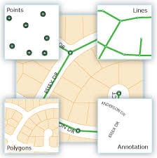
- Spatial Data Integration: GIS allows planners to combine multiple layers of information such as land-use maps, satellite imagery, road networks, population distribution, environmental data and property boundaries. These layers can be superimposed and analyzed simultaneously to reveal spatial patterns and relationships that are not easily visible through traditional mapping methods.
- Scenario Modeling and Planning: GIS enables planners to simulate different planning scenarios before implementing policies or development projects. For example, planners can model: the impact of constructing new roads, the effects of rezoning land for commercial development and the environmental consequences of urban expansion. Such simulations allow planners to compare alternative solutions and select the most efficient and sustainable option.
- Policy and Governance Support: GIS-generated maps and spatial analyses help government authorities communicate planning proposals clearly to policymakers and the public. Decision-makers can visually understand complex planning issues such as urban congestion, environmental degradation and land-use conflicts. As a result, GIS improves transparency, accountability, and effectiveness in urban planning decisions.
2.2 Better Land Management
Effective land management is a critical component of urban planning in Lagos due to the high demand for land and the complexity of land ownership systems. GIS-based cadastral systems provide a modern approach to managing land information by digitizing land records and integrating them into geospatial databases.
- Digital Cadastral Mapping: A cadastral system is a register of property ownership and land boundaries. GIS enables the creation of digital cadastral maps that accurately represent land parcels, property boundaries, and ownership information. Each parcel of land is assigned a unique spatial identifier linked to relevant attributes such as: ownership details, land-use classification, development permits and property values. This digital approach improves the accuracy and accessibility of land records.
- Reduction of Land Disputes: Land disputes are common in rapidly urbanizing cities due to unclear property boundaries, overlapping land claims, and fraudulent documentation. GIS helps reduce such disputes by providing accurate spatial representation of land boundaries, maintaining centralized land records and enabling quick verification of property ownership. These capabilities enhance transparency in land administration and reduce legal conflicts.
- Efficient Land Allocation: Government agencies responsible for urban development can use GIS to allocate land more efficiently for different purposes such as residential housing, industrial zones, transportation infrastructure and public facilities. Spatial analysis ensures that land allocation aligns with urban development plans and environmental considerations.
2.3 Sustainable Urban Development
Sustainable urban development aims to balance economic growth, social welfare, and environmental protection. GIS plays an important role in promoting sustainability by enabling planners to monitor environmental conditions and evaluate the long-term impacts of urban development.
- Environmental Monitoring: GIS allows planners to monitor environmental changes over time through spatial data analysis. This includes tracking: deforestation and vegetation loss, wetland degradation, water pollution and urban heat island effects. Such monitoring helps planners identify environmentally sensitive areas that require protection.
- Land Suitability Analysis: GIS tools can evaluate the suitability of land for different types of development by analyzing various factors such as soil characteristics, elevation and slope, flood risk and proximity to infrastructure. Through this analysis, planners can identify the most appropriate locations for residential, industrial, or commercial development while minimizing environmental damage.
- Green Infrastructure Planning: GIS also supports the planning of green infrastructure, including urban parks, green belts, conservation zones and ecological corridors. These features contribute to improved air quality, biodiversity conservation, and climate resilience in urban environments. In the context of Lagos, sustainable planning supported by GIS is crucial for protecting wetlands, managing coastal ecosystems, and maintaining ecological balance in the face of rapid urban expansion.
2.4 Disaster Risk Reduction
Urban areas are increasingly exposed to natural hazards such as flooding, coastal erosion, and extreme weather events. GIS plays a critical role in disaster risk reduction by providing tools for hazard mapping, vulnerability assessment, and emergency response planning.
- Hazard Mapping: GIS can be used to create hazard maps that identify areas exposed to environmental risks such as: flooding, storm surges, landslides and coastal erosion. These maps are produced by analyzing spatial data such as topography, rainfall patterns, drainage networks, and land-use characteristics.
- Flood Risk Assessment: Flooding is one of the most serious urban hazards affecting Lagos due to its low elevation and coastal location. GIS-based flood risk analysis involves modeling water flow patterns, identifying flood-prone areas and assessing the vulnerability of infrastructure and communities. Such analysis enables authorities to implement preventive measures such as improved drainage systems and flood control infrastructure.
- Emergency Response Planning: During disasters, GIS provides critical support for emergency management by mapping evacuation routes, identifying safe shelters, locating vulnerable populations and coordinating rescue operations. These capabilities improve disaster preparedness and reduce the potential loss of lives and property.
2.5 Efficient Infrastructure Planning
Infrastructure development is a major priority for urban planners in Lagos due to the city’s rapidly growing population and increasing demand for services.
GIS enhances infrastructure planning by providing tools for spatial analysis and optimization of urban service networks.
- Transportation Network Analysis: GIS enables planners to analyze transportation systems by mapping road networks and evaluating traffic patterns. Through network analysis, planners can identify traffic congestion points, optimize transportation routes, design efficient public transit systems and plan road expansions. Such analyses support initiatives aimed at improving urban mobility.
- Utility Infrastructure Planning: Urban utilities such as electricity, water supply, and telecommunications require efficient spatial distribution to serve large populations. GIS helps planners map and manage utility networks by locating infrastructure assets, analyzing service coverage and identifying underserved areas. This information supports better infrastructure investment decisions.
- Drainage and Stormwater Management: Lagos experiences frequent flooding due to heavy rainfall and inadequate drainage systems. GIS-based hydrological modeling enables planners to analyze drainage networks, identify areas with poor water flow and design improved stormwater management systems. Effective drainage planning reduces flood risk and enhances urban resilience.
- Public Service Delivery: GIS also supports the planning and management of public facilities such as: hospitals, schools, fire stations and waste management facilities. Spatial analysis helps determine the optimal locations for these services to ensure accessibility for urban residents.
- Conclusion
GIS provides numerous benefits for urban planning in Lagos by improving decision-making, enhancing land management, supporting sustainable development, reducing disaster risks, and optimizing infrastructure planning. As Lagos continues to experience rapid urbanization, the integration of GIS into planning processes will become increasingly important. By leveraging geospatial technologies, urban planners can design more efficient, resilient, and sustainable cities capable of meeting the needs of growing populations while protecting environmental resources.