
We offer a variety of surveying equipment and its usefulness has been commended to be top-notch. We often time let clients know that it is not wise to start building a piece of land without carrying out a precise survey on land. That’s why at Geoinfotech we make use of a variety of tools in observing and carrying out calculations during a field survey.
The surveying equipment we use during surveys:
Our surveyors this day’s work with equipped instrumentation to aid their investigations, mapping efforts, and measurements during geological fieldwork.
We make use of a vast set of equipment ranging from surveying rods for land, prism poles, GPS, theodolite, and so forth. All of which are needed for multiple survey purposes and measuring angles of points seen. Whereas the precision of our GPS is enhanced with real-time kinematic.
Some of this surveying equipment’s are very useful in the field and can be gotten from our online Geo-store
- Surveying tripods
- Story poles
- Measuring tape
- Surveyor’s brush axes
- Land surveying markers
- Land surveying rods,
- Marking paint
- Surveying prisms
- Prism poles
- Tersus David Single Rover For CORS Connection
- Garmin oregan 750t
- Ruide RCS Total Station
- Surveyor’s roll flagging
- Theodolites
- Tersus David plus GNSS RTK System
Mostly used surveying types of equipment are:
Theodolite – A measuring telescope used to ascertain horizontal and vertical axes, aligning the target at relative point positions on the ground.
Transit level – an optical instrument, or a telescope, with a built-in spirit level mounted on a tripod
Total station – it assumes the functionality of a theodolite to calculate and record features in topographic surveying or to set out features like roads, houses, or boundaries.
Surveying Tripod – a special tripod built to support surveying instruments, such as theodolites, total stations, levels, or transits
Surveying Prisms – is a corner cube or retroreflector, usually attached to a surveying pole and utilized as a target for distance measurement
Prism Poles –This measure the elevation of grounds already existing in conjunction with a survey level such as an Automatic Level, Transit Level, or Laser Level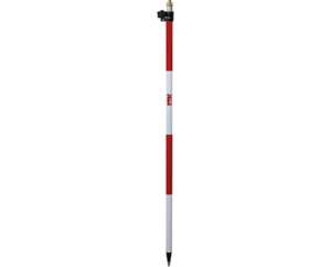
Benefits of our Land Surveying Equipment’s
- Purchasing our surveying equipment can help clients to reduce capital outlay and save money.
- They are the most up-to-date equipment on the market when hiring from us.
- Yes, we assure clients of reduced-cost maintenance of equipment.
- We offer expert advice on the best equipment to purchase and hire
Geoinfotech Resources Limited provide the best survey results and types of equipment for all sort of survey. By incorporating the best type of tool for the job, ensuring unique, speedy, and accurate measurements for every project.t
The task can be daunting but be rest assured that no matter the type of land survey needed, we have the proper tools in hand.
Also, visit our Geostore today for affordable and exciting product sale offers https://geoinfotechstore.com/


