Document

How to Beat Lagos Traffic: Using DJI FlyCart 100 for Heavy-Lift Delivery

If you live or work in Lagos, you already know one thing, traffic can slow down everything.

From Apapa to Victoria Island, Lekki to Ikeja, logistics delays cost businesses time, money, and customer trust. But what if there was a faster, smarter way to move goods across the city?

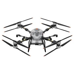
Enter the DJI FlyCart 100, a heavy-lift delivery drone designed to bypass traffic completely and deliver items through the air.

In this article, we’ll explore how this powerful drone can transform logistics in Lagos, especially for businesses dealing with urgent or heavy deliveries.

The Problem: Lagos Traffic & Logistics Delays

Lagos is one of the busiest cities in Africa, and traffic congestion affects:

  • E-commerce deliveries 
  • Construction logistics 
  • Medical supply transport 
  • Industrial operations

Common challenges include:

  • Unpredictable delivery times 
  • Fuel and operational costs 
  • Delayed business operations 
  • Customer dissatisfaction

This is why companies are now exploring drone delivery solutions.

Meet the DJI FlyCart 100

The DJI FlyCart 100 is a heavy-lift delivery drone designed for industrial logistics.

Key Features

  • High Payload Capacity → Designed for heavy cargo delivery 
  • Long Range → Ideal for moving goods across large distances 
  • Smart Delivery System → Includes winch delivery for precise drop-offs 
  • Obstacle Avoidance → Safe in complex environments 
  • Weather Resistance → Can operate in moderate weather conditions

This makes it perfect for urban logistics in Lagos.

How the FlyCart 100 Helps Beat Lagos Traffic

Bypassing Road Congestion

Unlike trucks and bikes, drones fly above traffic, eliminating delays caused by:

  • Gridlocks 
  • Road construction 
  • Accidents

Deliveries that take 2–4 hours by road can be completed in minutes by air.

Faster Delivery for Critical Goods

The FlyCart 100 is ideal for:

  • Medical supplies 
  • Emergency equipment 
  • High-value items 
  • Urgent business deliveries

In time-sensitive situations, speed can make a huge difference.

Efficient Heavy-Lift Logistics

Unlike smaller drones, the FlyCart 100 can handle heavy payloads, making it suitable for:

  • Construction materials 
  • Tools and equipment 
  • Industrial supplies

This is especially useful for hard-to-reach locations.

Access to Remote or Restricted Areas

In places where vehicles struggle, such as:

  • Construction sites 
  • Offshore locations 
  • Flooded or restricted zones

The FlyCart 100 can deliver goods directly without physical access roads.

Reduced Operational Costs Over Time

While the initial investment may be high, drone delivery helps reduce:

  • Fuel costs 
  • Driver expenses 
  • Vehicle maintenance 
  • Delivery delays

Over time, this leads to better efficiency and higher ROI.

Real Use Cases in Lagos

Here’s how businesses in Lagos can use the FlyCart 100:

1. Construction Companies

Deliver tools and materials quickly to sites in Lekki and Epe.

2. Hospitals & Healthcare

Transport urgent medical supplies across traffic-heavy areas.

3. E-commerce & Logistics

Speed up last-mile delivery for customers.

4. Oil & Gas / Industrial Operations

Move equipment to restricted or offshore locations.

Where to Get the DJI FlyCart 100 in Lagos

For businesses looking to adopt drone logistics, sourcing from a trusted supplier is key.

Stores like GeoStore provide:

  • Enterprise drones 
  • Logistics drone solutions 
  • Technical support and setup 
  • Training for operations

Buying from a reliable provider ensures genuine equipment and proper deployment guidance.

Challenges to Consider

Before deploying drone delivery in Lagos, consider:

  • Regulatory approvals (aviation laws) 
  • Airspace restrictions 
  • Operational training requirements 
  • Weather conditions

Proper planning is essential for safe and legal operations.

Final Thoughts

Lagos traffic isn’t going away anytime soon, but how we navigate it is changing.

The DJI FlyCart 100 offers a futuristic solution to logistics challenges by:

  • Delivering faster 
  • Reducing delays 
  • Improving efficiency 
  • Unlocking new business opportunities

For forward-thinking companies in Lagos, drone delivery is not just innovation, it’s a competitive advantage.

RECENT ACTIVITIES AND PROJECT...

URABN HEAT ISLAND EFFECT IN CALABAR MUNICIPAL

URABN HEAT ISLAND EFFECT IN CALABAR MUNICIPAL

ANALYZING URBANIZATION TRENDS IN KANO STATE, NIGERIA USING NIGHTTIME LIGHTS REMOTE SENSING DATA

ANALYZING URBANIZATION TRENDS IN KANO STATE, NIGERIA USING NIGHTTIME LIGHTS REMOTE SENSING DATA

COMPREHENSIVE OFFSHORE SURVEILLANCE AND MARITIME INFRASTRUCTURE MONITORING

COMPREHENSIVE OFFSHORE SURVEILLANCE AND MARITIME INFRASTRUCTURE MONITORING

Comprehensive Aerial Survey and Mapping for Golf Course Asset Management at Lakowe Golf Lake

Comprehensive Aerial Survey and Mapping for Golf Course Asset Management at Lakowe Golf Lake

Professional Drone Training Program for Enhanced Corporate Security Operations at Sahara Group

Professional Drone Training Program for Enhanced Corporate Security Operations at Sahara Group

Advanced Aerial Topographic Survey and Mapping for Land Development in Ogun State

Advanced Aerial Topographic Survey and Mapping for Land Development in Ogun State

Precision RGB and Thermal Imaging Revolutionizes Solar Infrastructure Inspection In Enugu

Precision RGB and Thermal Imaging Revolutionizes Solar Infrastructure Inspection In Enugu

Advanced Drone-Based Topographic Survey for Precision Land Development Planning

Advanced Drone-Based Topographic Survey for Precision Land Development Planning

Mapping the Future: Comprehensive Area Survey Transforms Land Development in Akure

Mapping the Future: Comprehensive Area Survey Transforms Land Development in Akure

Precision Topographical Survey and Mapping for Smarter Infrastructure Planning

Precision Topographical Survey and Mapping for Smarter Infrastructure Planning

Precision Drone Volumetric Surveys: How Purechem Industries Optimized Mineral Stockpile Management

Precision Drone Volumetric Surveys: How Purechem Industries Optimized Mineral Stockpile Management

Advanced Mapping & Environmental Survey for Ilubirin Property, Lagos Island

Advanced Mapping & Environmental Survey for Ilubirin Property, Lagos Island

Unveiling the Invisible: LiDAR Technology Transforms Terrain Analysis in Abeokuta North

Unveiling the Invisible: LiDAR Technology Transforms Terrain Analysis in Abeokuta North

 DETAILED AERIAL, LAND SURVEY AND GIS ANALYSIS FOR ADVANCED REAL ESTATE DEVELOPMENT

 DETAILED AERIAL, LAND SURVEY AND GIS ANALYSIS FOR ADVANCED REAL ESTATE DEVELOPMENT

Professional Drone Mapping and GIS Training For ETA-ZUMA Mining Company

Professional Drone Mapping and GIS Training For ETA-ZUMA Mining Company

Installation of Intelligent Traffic Lights

Installation of Intelligent Traffic Lights

Geological Report on a Mining/Exploration Survey

Geological Report on a Mining/Exploration Survey

Drone Survey and Mapping of Shaishen Foods Limited

Drone Survey and Mapping of Shaishen Foods Limited

Lidar Topographic Mapping Project

Lidar Topographic Mapping Project

Geophysical/hydrogeophysical Studies for Groundwater Development

Geophysical/hydrogeophysical Studies for Groundwater Development

Togo Digital Terrain Model Project

Togo Digital Terrain Model Project

Drone Mapping of Parts of Lome Rail Line for Graceland Energy Located at Lome Togo

Drone Mapping of Parts of Lome Rail Line for Graceland Energy Located at Lome Togo

Drone/land Survey of Pure-chem Industrial Limited, Ogun State.

Drone/land Survey of Pure-chem Industrial Limited, Ogun State.

Drone Inspection/survey of Southern Lake Estate, Chevron, Lekki, Lagos State

Drone Inspection/survey of Southern Lake Estate, Chevron, Lekki, Lagos State

Anniversary-Workshop on the Application of Remote Sensing and Drone Technology in GIS -Abuja

Anniversary-Workshop on the Application of Remote Sensing and Drone Technology in GIS -Abuja

Topographic Mapping of Oyo State

Topographic Mapping of Oyo State

Topographic Mapping of Part of the Local Government Areas in Oyo State

Topographic Mapping of Part of the Local Government Areas in Oyo State

Topographic Mapping of Part of Kwara, Ekiti and Kogi State Local Government Area

Topographic Mapping of Part of Kwara, Ekiti and Kogi State Local Government Area

Political Map of South West, Nigeria Located in Nigeria

Political Map of South West, Nigeria Located in Nigeria

Topographic Mapping of Parts of Niger State Located at Niger State, Nigeria

Topographic Mapping of Parts of Niger State Located at Niger State, Nigeria

Topographic Mapping of Part of Kwara, Ekiti, and Kogi State Local Government Area Located in Nigeria

Topographic Mapping of Part of Kwara, Ekiti, and Kogi State Local Government Area Located in Nigeria

Topographic Mapping of Part of Kwara State Local Government Area Located at Kwara State Nigeria

Topographic Mapping of Part of Kwara State Local Government Area Located at Kwara State Nigeria

Flood Analysis of Amuwo-odofin Orthophoto.

Flood Analysis of Amuwo-odofin Orthophoto.

Site Inspection Using Drone of Water Corporation Located at Oke-aro Agege

Site Inspection Using Drone of Water Corporation Located at Oke-aro Agege

24,000 meter Lome Rail Line for Drone Mapping, Graceland Energy Located at Lome, Togo

24,000 meter Lome Rail Line for Drone Mapping, Graceland Energy Located at Lome, Togo

10 Drone Inspection Traffic Signal in Lagos

10 Drone Inspection Traffic Signal in Lagos

Lagos October 1st Free GIS Training Workshop

Lagos October 1st Free GIS Training Workshop

Osun state parcel project

Osun state parcel project

Drone Mapping & Vectorization Of Abu-allied Farm

Drone Mapping & Vectorization Of Abu-allied Farm

Proposal for aerial deployment, tracking and monitoring of threats in victoria island phase 1 and ikoyi phase 2, nigeria

Proposal for aerial deployment, tracking and monitoring of threats in victoria island phase 1 and ikoyi phase 2, nigeria

Jabi Lake Mall Solar Inspection – Abuja

Jabi Lake Mall Solar Inspection – Abuja

Ground Control and Drone Survey for Mast 3D Modeling

Ground Control and Drone Survey for Mast 3D Modeling

Telecom Drone 3D and 2D Modeling of Cellsite

Telecom Drone 3D and 2D Modeling of Cellsite

Free GIS Spatial Analysis Training (Lagos Branch)

Free GIS Spatial Analysis Training (Lagos Branch)

800 Building Plots Aerial Capture and Delineation for Database. Greenfield Estate

800 Building Plots Aerial Capture and Delineation for Database. Greenfield Estate

100 Hectares Aerial Survey with Differential GPS of High Accuracy

100 Hectares Aerial Survey with Differential GPS of High Accuracy

Protected: Nigeria Crime Report and Dashboard

Protected: Nigeria Crime Report and Dashboard

Drone Survey and Mapping – Victoria Island  Copy

Drone Survey and Mapping – Victoria Island Copy

Akwa-Ibom 500 Hectares Drone Survey and Mapping in Nigeria

Akwa-Ibom 500 Hectares Drone Survey and Mapping in Nigeria

Ground Control Establishment – Republic of the Niger – Kano, Kastina, Jigawa, Kaduna

Ground Control Establishment – Republic of the Niger – Kano, Kastina, Jigawa, Kaduna

Drone Survey and Mapping – Victoria Island

Drone Survey and Mapping – Victoria Island

Control Point Establishment – DGPS

Control Point Establishment – DGPS

Land Survey – Northern Nigeria

Land Survey – Northern Nigeria

Biodiversity Mapping – Sweden

Biodiversity Mapping – Sweden

Flood Impact Mapping – United Kingdom

Flood Impact Mapping – United Kingdom

M and E GIS Dashboard for Control Establishment Project

M and E GIS Dashboard for Control Establishment Project

Geodatabase Management System Training For National Boundary Commission

Geodatabase Management System Training For National Boundary Commission

Nigeria Topographic Map – Project

Nigeria Topographic Map – Project

Abuja Training on Introduction to GIS

Abuja Training on Introduction to GIS

200 Hectares Land and Drone Survey – Lagos Nigeria

200 Hectares Land and Drone Survey – Lagos Nigeria

Inspection of 30 hectares drainage

Inspection of 30 hectares drainage

Drainage Drone Mapping and Surveying in Lagos Nigeria

Drainage Drone Mapping and Surveying in Lagos Nigeria

GIS Cadastral Mobile Application

GIS Cadastral Mobile Application

Abuja Topographical Map – HD GIS Mapping

Abuja Topographical Map – HD GIS Mapping

Ground Topography Survey (Lagos Island)

Ground Topography Survey (Lagos Island)

2.7km2 Topography Survey in Snake Island

2.7km2 Topography Survey in Snake Island

GIS Masterclass

GIS Masterclass

Sokoto Contour Map

Sokoto Contour Map

NDVI Vegetation Assessment in Lagos State

NDVI Vegetation Assessment in Lagos State

Lagos drone training master class

Lagos drone training master class

Ifako drone topographic survey and mapping

Ifako drone topographic survey and mapping

CMD Lagos 3D mapping aerial modeling

CMD Lagos 3D mapping aerial modeling

GIS and Drone Masterclass

GIS and Drone Masterclass

Drone aerial survey and mapping – Lagos Island _ Somolu

Drone aerial survey and mapping – Lagos Island _ Somolu

Covid-19 | Nigeria Data Visualisation

Covid-19 | Nigeria Data Visualisation

Benue Flood Analysis

Benue Flood Analysis

Aerial photography Ile-Ife Osun State

Aerial photography Ile-Ife Osun State

Kenya Forest Project

Kenya Forest Project

Tunsun Consultants Ltd

Tunsun Consultants Ltd

Introduction To Gis In Maritime at the National Boundary Commission

Introduction To Gis In Maritime at the National Boundary Commission

Training on GIS and Drone Mapping (batch-4 & 5)

Training on GIS and Drone Mapping (batch-4 & 5)

Osun Flood Mapping

Osun Flood Mapping

Lahass International Limited

Lahass International Limited

Linguistic Association of Nigeria

Linguistic Association of Nigeria

West African Indexing Services

West African Indexing Services

Lagos Ikeja Road Network Map

Lagos Ikeja Road Network Map

LASU Land Regularisation Portal

LASU Land Regularisation Portal

Lingua Plus International

Lingua Plus International

Lagferry Web Route

Lagferry Web Route

YOU MAY ALSO LIKE...

COURSES

Explore Geoinfotech courses and establish a strong foundation of knowledge and skills to be productive with the latest Technology.

[Beginners to Professional] short training program

Our professional short courses deliver practical, hands-on training in GIS, Drone Operations, and Surveying, designed to build industry-ready skills in…

Find out more

2-DAY DRONE PILOT TRAINING FOR UNIVERSITY OF LAGOS

This intensive 2-day drone pilot training is designed to equip participants with both the theoretical knowledge and hands-on practical skills…

Find out more

Differential GPS (DGPS) Land Surveying Training

Professional 2 weekends ▪ Field Experience 5.0 (100% Practical) ▪ Exam & CertificateFree Software and AppsHands on Practical and Field…

Find out more

Training on AutoCAD for Surveying and Mapping

Duration: 4 Weekends (Every Friday 2pm and Saturday 10am)
Package: Field Experience, 100% Hands-on practical, jotter, Biro and Software Others, Test, Exam and Certificate.

Find out more
Training Venue Available in,Lagos and Abuja100253Nigeria
+ Google Map