We are Passionate About proffering the best of service you need
No 1 Industry leader in Geo-Spatial Technology Solution Deployment,
We believe in the power of geospatial technology to transform, modernise, develop and expand our knowledge on earth systems through the processing of satellite imageries, drone-based aerial photographs, smart design of maps and web applications.
What we do:
We bring art and science together to build innovative entrepreneurship and technology at Geoinfotech
We create geospatial products, GIS, Drone Surveying, Mapping, Remote Sensing, Web Application, and full drone services for data processing, analysis, mapping
Providing accurate and precise data and maps to achieve your strategic goals.
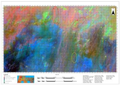
GIS AND REMOTE SENSING
Our expertise in geo-technology and our robust Geographic Information Systems (GIS) store empower us to manage and process spatial data. At Geoinfotech, we always work with leading market software to deliver the best possible results.
Contact us to achieve your strategic goals through effective deployment of Geospatial technology.

DRONE SERVICES
- Topography Surveying and Mapping
- Photography 3D Visualization
- Drone Inspection
- Precision Agriculture Around, legal industrial espionage, industry-specific drone business opportunities


- Aerial Topography Survey and Mapping
- Image & Video Post-Processing
- Data with Accuracy upto millimeter

- Drone mapping Photogrammetry Creating 3D models from 2D aerial photos.
SURVEYING AND MAPPING
Our expertise in Land and Water Surveying
Engineering survey services
Cadastral Surveying services
Topographic surveying
Surveying & Mapping
We work with precision and accuracy
Coming Soon
Download and access geosaptial technology, softcopy and hardcopy
GeoStore – Download maps and data
SURVEYING AND MAPPING
Our expertise in Land and Water Surveying
LAND SURVEY
- Land Surveying
- Engineering Survey
- Gis & Mapping
- Drone Survey (Aerial Data Collection)
- 3D Elevation Modeling
- Bathymetry
- More…
Surveying & Mapping
We work with precision and accuracy
Geoinfotech Training Program
We are passionate in proffering the best of value and uplifting the education sector
About our Training
Basic – Advance Training on GIS, Remote Sensing and Drone Mapping, to Professional bodies, Organisations and Staffs
Geoinfotech Courses
Training for Individuals and Organisations
Check out more on available courses and Events
Statement
GEOINFORMATION – TECHNOLOGY EVERYWHERE
We aim to:
Develop innovative technological applications and services that address real-world problems through Geospatial Information Technology
WHY GEOINFOTECH?
- We are known for 1st Class quality services
- We boast of a pool of experienced and a reliable team
- We work collectively to provide cutting edge information and insights that meet our client satisfaction
Our Portfolio
Check out our previous projects on GIS, Drone, Land Surveyor and Mapping Services in Nigeria


For any inquires call now
Contact us
Do you have any query?
Start a Project with us
- GIS and Remote Sensing
- Drone Land and Water Surveying
- Drone Data Processing and Mapping
- Surveying and Mapping
- Website Development