Document
What is Aerial Mapping?

Aerial mapping is the process of capturing images and data from above using aircraft, drones, or other flying objects. This data can then be used to create maps, 3D models, and other geospatial products. Aerial mapping has a wide range of applications in a variety of industries, including:

Agriculture: Farmers can use aerial mapping to monitor crop health, assess irrigation needs, and track yields.

Farm aerial mapping

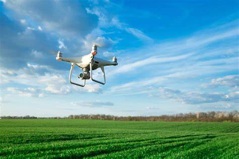
Figure 1: Drone flying over a farm

Construction: Construction companies can use aerial mapping to track the progress of construction projects, measure volumes of materials, and identify potential safety hazards.

Construction mapping

Figure2: Drone flying over a construction site

Forestry: Foresters can use aerial mapping to assess forest health, track deforestation, and manage fire risk.

Forest Aerial Surveying

Figure 3: Drone flying over a forest

Mining: Mining companies can use aerial mapping to measure stockpiles, monitor mine operations, and identify potential environmental hazards.

Mine Aerial surveying

Figure 4: Drone flying over a mine

Real estate: Real estate agents can use aerial mapping to create virtual tours of properties, measure land areas, and identify potential development opportunities.

Urban planning: City planners can use aerial mapping to create 3D models of cities, track urban development, and plan for future infrastructure needs.

Urban planning

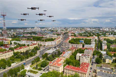
Figure 5: Urban Planning

Benefits of aerial mapping

There are many benefits to using aerial mapping, including:

  • Increased accuracy and efficiency: Aerial mapping can provide more accurate and up-to-date data than traditional ground-based methods.
  • Improved safety: Aerial mapping can be used to collect data from dangerous or inaccessible areas.
  • Reduced costs: Aerial mapping can be more cost-effective than traditional methods, especially for large or complex projects.
  • Better decision-making: Aerial mapping can provide valuable insights that can help businesses and organizations make better decisions.

What is the Purpose of an Aerial Map?

An aerial map is a map created from images taken from above the ground, typically by aircraft, drones, or satellites. These images can be used to create a variety of map products, including:

Topographic maps: These maps show the physical features of an area, such as mountains, rivers, and valleys.

Aerial Mapping

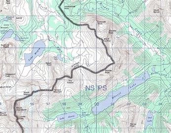
Figure 6: Topographic Map

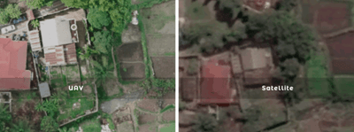
Orthophotos: These are high-resolution images that have been corrected for geometric distortions, making them accurate representations of the ground below.

Aerial Mapping

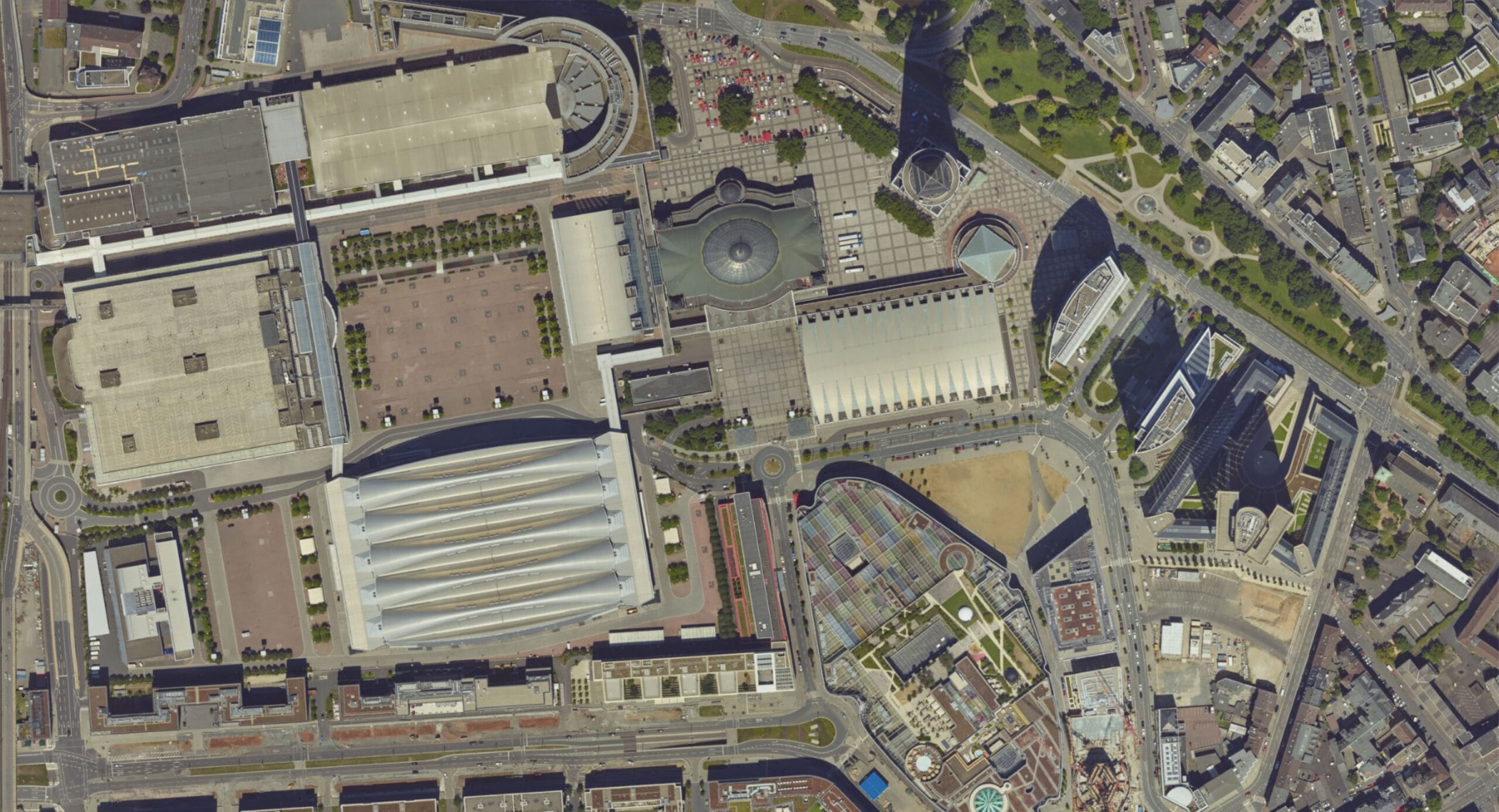
Figure 7: Orthophoto

3D models: These models can be used to visualize an area in three dimensions, which can be helpful for planning and design purposes.
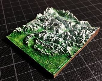
Aerial

Figure 8: 3D Map

The Meaning of an Aerial View Map

The meaning of an aerial view map can vary depending on the purpose of the map. For example, a topographic map may be used to show the elevation of different features, while an orthophoto may be used to identify specific objects on the ground. However, there are some general things that all aerial view maps can tell us:

  • The layout of an area: Aerial view maps can show us the relative positions of different features, such as buildings, roads, and bodies of water.
  • The size and shape of features: Aerial view maps can help us to measure the size and shape of features, such as buildings, fields, and forests.
  • The relationships between features: Aerial view maps can help us to see how different features are related to each other, such as how roads connect buildings or how rivers flow through valleys.

Applications of Aerial View Maps

Aerial view maps have a wide range of applications, including:

  • Urban planning: Aerial view maps can be used to plan the development of cities, towns, and other communities.
  • Infrastructure management: Aerial view maps can be used to manage infrastructure, such as roads, bridges, and pipelines.
  • Environmental monitoring: Aerial view maps can be used to monitor environmental changes, such as deforestation and pollution.
  • Disaster relief: Aerial view maps can be used to assess damage after natural disasters and to coordinate relief efforts.
  • Military operations: Aerial view maps are used extensively in military operations for planning, reconnaissance, and targeting.

The future of aerial mapping

Aerial mapping is a rapidly growing industry, and new technologies are emerging all the time. In the future, we can expect to see even more applications for aerial mapping, as well as more accurate, efficient, and affordable solutions.

Conclusion

Aerial view maps are a valuable tool that can be used for a variety of purposes. They provide a unique perspective on the world that can be used to make better decisions about how we plan, manage, and protect our environment.

RECENT ACTIVITIES AND PROJECT...

URABN HEAT ISLAND EFFECT IN CALABAR MUNICIPAL

URABN HEAT ISLAND EFFECT IN CALABAR MUNICIPAL

ANALYZING URBANIZATION TRENDS IN KANO STATE, NIGERIA USING NIGHTTIME LIGHTS REMOTE SENSING DATA

ANALYZING URBANIZATION TRENDS IN KANO STATE, NIGERIA USING NIGHTTIME LIGHTS REMOTE SENSING DATA

COMPREHENSIVE OFFSHORE SURVEILLANCE AND MARITIME INFRASTRUCTURE MONITORING

COMPREHENSIVE OFFSHORE SURVEILLANCE AND MARITIME INFRASTRUCTURE MONITORING

Comprehensive Aerial Survey and Mapping for Golf Course Asset Management at Lakowe Golf Lake

Comprehensive Aerial Survey and Mapping for Golf Course Asset Management at Lakowe Golf Lake

Professional Drone Training Program for Enhanced Corporate Security Operations at Sahara Group

Professional Drone Training Program for Enhanced Corporate Security Operations at Sahara Group

Advanced Aerial Topographic Survey and Mapping for Land Development in Ogun State

Advanced Aerial Topographic Survey and Mapping for Land Development in Ogun State

Precision RGB and Thermal Imaging Revolutionizes Solar Infrastructure Inspection In Enugu

Precision RGB and Thermal Imaging Revolutionizes Solar Infrastructure Inspection In Enugu

Advanced Drone-Based Topographic Survey for Precision Land Development Planning

Advanced Drone-Based Topographic Survey for Precision Land Development Planning

Mapping the Future: Comprehensive Area Survey Transforms Land Development in Akure

Mapping the Future: Comprehensive Area Survey Transforms Land Development in Akure

Precision Topographical Survey and Mapping for Smarter Infrastructure Planning

Precision Topographical Survey and Mapping for Smarter Infrastructure Planning

Precision Drone Volumetric Surveys: How Purechem Industries Optimized Mineral Stockpile Management

Precision Drone Volumetric Surveys: How Purechem Industries Optimized Mineral Stockpile Management

Advanced Mapping & Environmental Survey for Ilubirin Property, Lagos Island

Advanced Mapping & Environmental Survey for Ilubirin Property, Lagos Island

Unveiling the Invisible: LiDAR Technology Transforms Terrain Analysis in Abeokuta North

Unveiling the Invisible: LiDAR Technology Transforms Terrain Analysis in Abeokuta North

 DETAILED AERIAL, LAND SURVEY AND GIS ANALYSIS FOR ADVANCED REAL ESTATE DEVELOPMENT

 DETAILED AERIAL, LAND SURVEY AND GIS ANALYSIS FOR ADVANCED REAL ESTATE DEVELOPMENT

Professional Drone Mapping and GIS Training For ETA-ZUMA Mining Company

Professional Drone Mapping and GIS Training For ETA-ZUMA Mining Company

Installation of Intelligent Traffic Lights

Installation of Intelligent Traffic Lights

Geological Report on a Mining/Exploration Survey

Geological Report on a Mining/Exploration Survey

Drone Survey and Mapping of Shaishen Foods Limited

Drone Survey and Mapping of Shaishen Foods Limited

Lidar Topographic Mapping Project

Lidar Topographic Mapping Project

Geophysical/hydrogeophysical Studies for Groundwater Development

Geophysical/hydrogeophysical Studies for Groundwater Development

Togo Digital Terrain Model Project

Togo Digital Terrain Model Project

Drone Mapping of Parts of Lome Rail Line for Graceland Energy Located at Lome Togo

Drone Mapping of Parts of Lome Rail Line for Graceland Energy Located at Lome Togo

Drone/land Survey of Pure-chem Industrial Limited, Ogun State.

Drone/land Survey of Pure-chem Industrial Limited, Ogun State.

Drone Inspection/survey of Southern Lake Estate, Chevron, Lekki, Lagos State

Drone Inspection/survey of Southern Lake Estate, Chevron, Lekki, Lagos State

Anniversary-Workshop on the Application of Remote Sensing and Drone Technology in GIS -Abuja

Anniversary-Workshop on the Application of Remote Sensing and Drone Technology in GIS -Abuja

Topographic Mapping of Oyo State

Topographic Mapping of Oyo State

Topographic Mapping of Part of the Local Government Areas in Oyo State

Topographic Mapping of Part of the Local Government Areas in Oyo State

Topographic Mapping of Part of Kwara, Ekiti and Kogi State Local Government Area

Topographic Mapping of Part of Kwara, Ekiti and Kogi State Local Government Area

Political Map of South West, Nigeria Located in Nigeria

Political Map of South West, Nigeria Located in Nigeria

Topographic Mapping of Parts of Niger State Located at Niger State, Nigeria

Topographic Mapping of Parts of Niger State Located at Niger State, Nigeria

Topographic Mapping of Part of Kwara, Ekiti, and Kogi State Local Government Area Located in Nigeria

Topographic Mapping of Part of Kwara, Ekiti, and Kogi State Local Government Area Located in Nigeria

Topographic Mapping of Part of Kwara State Local Government Area Located at Kwara State Nigeria

Topographic Mapping of Part of Kwara State Local Government Area Located at Kwara State Nigeria

Flood Analysis of Amuwo-odofin Orthophoto.

Flood Analysis of Amuwo-odofin Orthophoto.

Site Inspection Using Drone of Water Corporation Located at Oke-aro Agege

Site Inspection Using Drone of Water Corporation Located at Oke-aro Agege

24,000 meter Lome Rail Line for Drone Mapping, Graceland Energy Located at Lome, Togo

24,000 meter Lome Rail Line for Drone Mapping, Graceland Energy Located at Lome, Togo

10 Drone Inspection Traffic Signal in Lagos

10 Drone Inspection Traffic Signal in Lagos

Lagos October 1st Free GIS Training Workshop

Lagos October 1st Free GIS Training Workshop

Osun state parcel project

Osun state parcel project

Drone Mapping & Vectorization Of Abu-allied Farm

Drone Mapping & Vectorization Of Abu-allied Farm

Proposal for aerial deployment, tracking and monitoring of threats in victoria island phase 1 and ikoyi phase 2, nigeria

Proposal for aerial deployment, tracking and monitoring of threats in victoria island phase 1 and ikoyi phase 2, nigeria

Jabi Lake Mall Solar Inspection – Abuja

Jabi Lake Mall Solar Inspection – Abuja

Ground Control and Drone Survey for Mast 3D Modeling

Ground Control and Drone Survey for Mast 3D Modeling

Telecom Drone 3D and 2D Modeling of Cellsite

Telecom Drone 3D and 2D Modeling of Cellsite

Free GIS Spatial Analysis Training (Lagos Branch)

Free GIS Spatial Analysis Training (Lagos Branch)

800 Building Plots Aerial Capture and Delineation for Database. Greenfield Estate

800 Building Plots Aerial Capture and Delineation for Database. Greenfield Estate

100 Hectares Aerial Survey with Differential GPS of High Accuracy

100 Hectares Aerial Survey with Differential GPS of High Accuracy

Protected: Nigeria Crime Report and Dashboard

Protected: Nigeria Crime Report and Dashboard

Drone Survey and Mapping – Victoria Island  Copy

Drone Survey and Mapping – Victoria Island Copy

Akwa-Ibom 500 Hectares Drone Survey and Mapping in Nigeria

Akwa-Ibom 500 Hectares Drone Survey and Mapping in Nigeria

Ground Control Establishment – Republic of the Niger – Kano, Kastina, Jigawa, Kaduna

Ground Control Establishment – Republic of the Niger – Kano, Kastina, Jigawa, Kaduna

Drone Survey and Mapping – Victoria Island

Drone Survey and Mapping – Victoria Island

Control Point Establishment – DGPS

Control Point Establishment – DGPS

Land Survey – Northern Nigeria

Land Survey – Northern Nigeria

Biodiversity Mapping – Sweden

Biodiversity Mapping – Sweden

Flood Impact Mapping – United Kingdom

Flood Impact Mapping – United Kingdom

M and E GIS Dashboard for Control Establishment Project

M and E GIS Dashboard for Control Establishment Project

Geodatabase Management System Training For National Boundary Commission

Geodatabase Management System Training For National Boundary Commission

Nigeria Topographic Map – Project

Nigeria Topographic Map – Project

Abuja Training on Introduction to GIS

Abuja Training on Introduction to GIS

200 Hectares Land and Drone Survey – Lagos Nigeria

200 Hectares Land and Drone Survey – Lagos Nigeria

Inspection of 30 hectares drainage

Inspection of 30 hectares drainage

Drainage Drone Mapping and Surveying in Lagos Nigeria

Drainage Drone Mapping and Surveying in Lagos Nigeria

GIS Cadastral Mobile Application

GIS Cadastral Mobile Application

Abuja Topographical Map – HD GIS Mapping

Abuja Topographical Map – HD GIS Mapping

Ground Topography Survey (Lagos Island)

Ground Topography Survey (Lagos Island)

2.7km2 Topography Survey in Snake Island

2.7km2 Topography Survey in Snake Island

GIS Masterclass

GIS Masterclass

Sokoto Contour Map

Sokoto Contour Map

NDVI Vegetation Assessment in Lagos State

NDVI Vegetation Assessment in Lagos State

Lagos drone training master class

Lagos drone training master class

Ifako drone topographic survey and mapping

Ifako drone topographic survey and mapping

CMD Lagos 3D mapping aerial modeling

CMD Lagos 3D mapping aerial modeling

GIS and Drone Masterclass

GIS and Drone Masterclass

Drone aerial survey and mapping – Lagos Island _ Somolu

Drone aerial survey and mapping – Lagos Island _ Somolu

Covid-19 | Nigeria Data Visualisation

Covid-19 | Nigeria Data Visualisation

Benue Flood Analysis

Benue Flood Analysis

Aerial photography Ile-Ife Osun State

Aerial photography Ile-Ife Osun State

Kenya Forest Project

Kenya Forest Project

Tunsun Consultants Ltd

Tunsun Consultants Ltd

Introduction To Gis In Maritime at the National Boundary Commission

Introduction To Gis In Maritime at the National Boundary Commission

Training on GIS and Drone Mapping (batch-4 & 5)

Training on GIS and Drone Mapping (batch-4 & 5)

Osun Flood Mapping

Osun Flood Mapping

Lahass International Limited

Lahass International Limited

Linguistic Association of Nigeria

Linguistic Association of Nigeria

West African Indexing Services

West African Indexing Services

Lagos Ikeja Road Network Map

Lagos Ikeja Road Network Map

LASU Land Regularisation Portal

LASU Land Regularisation Portal

Lingua Plus International

Lingua Plus International

Lagferry Web Route

Lagferry Web Route

YOU MAY ALSO LIKE...

COURSES

Explore Geoinfotech courses and establish a strong foundation of knowledge and skills to be productive with the latest Technology.

Differential GPS (DGPS) Land Surveying Training

Professional 2 weekends ▪ Field Experience 5.0 (100% Practical) ▪ Exam & CertificateFree Software and AppsHands on Practical and Field…

Find out more

Drone Pilot for Beginners to Professional

The Drone Professional Training course is a comprehensive program designed to equip participants with the necessary skills and knowledge to operate drones effectively and safely in a professional setting.
Duration: 3 Weekends (Every Friday 2pm and Saturday 10am)
Package: Field Experience, 100% Hands-on practical, jotter, Biro and Software Others, Test, Exam and Certificate.

Find out more
Training Venue Available in,Lagos and Abuja100253Nigeria
+ Google Map

1000 University Student in Drone and GIS

This course is designed to equip university students with the essential knowledge and practical skills needed to become proficient in…

Find out more

Training on AutoCAD for Surveying and Mapping

Duration: 4 Weekends (Every Friday 2pm and Saturday 10am)
Package: Field Experience, 100% Hands-on practical, jotter, Biro and Software Others, Test, Exam and Certificate.

Find out more
Training Venue Available in,Lagos and Abuja100253Nigeria
+ Google Map