Drone surveying for mining Nigeria.
Mining and quarry operations depend on accurate measurements.
A small error in a stockpile estimate can create a significant financial difference. The problem becomes even greater when an operation manages several sites or large volumes of material.
Traditional measurement methods often rely on a limited number of ground survey points. They can also require personnel to work close to stockpiles, pit faces, haul roads, and other potentially hazardous areas.
Drone surveying for mining in Nigeria provides a safer and more detailed approach.
A drone can capture thousands of overlapping images across a mining or quarry site. Photogrammetry or LiDAR can then turn that data into a detailed 3D model.
From this model, mining teams can calculate stockpile volumes, monitor pit progression, analyse terrain, and create accurate site records.
Why Traditional Mining Measurements Can Be Difficult
Ground-based surveys remain valuable in mining. However, some site conditions make traditional measurement difficult.
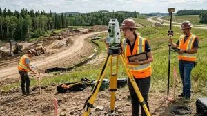
A surveyor may need to access steep stockpiles, unstable material, active pit benches, or busy haul roads.
This creates safety challenges.
Ground surveys can also capture a limited number of points across a large or irregular stockpile. The resulting model may therefore rely on a sample of the surface rather than a detailed representation of the entire pile.
Active mining operations create another challenge.
Survey teams may need to work around excavation equipment, haul trucks, and other vehicles. In some situations, operations may need to slow down or stop while measurements take place.
Drone surveying reduces the need for personnel to physically access many of these areas.
How Drone Volumetric Surveys Work
A drone flies over the mining, quarry, or stockpile area and captures overlapping aerial images.
Depending on the project, the system may use photogrammetry or LiDAR.
Photogrammetry
Photogrammetry uses overlapping photographs to reconstruct the site’s three-dimensional surface.
The processing software identifies common features across multiple images. It then creates a point cloud containing a large number of 3D points.
This point cloud can form the basis for a surface model and volumetric calculation.
Photogrammetry works particularly well on sites with good lighting and sufficient surface texture.
LiDAR
LiDAR uses laser measurements to capture three-dimensional information.
It can provide advantages in some mining environments where photogrammetry may face challenges.
For example, deep pit walls can create shadows. Uniform materials can also provide limited visual texture for image matching.
LiDAR can also perform well in some low-light conditions and may offer advantages where airborne dust affects conventional imagery.
The best sensor depends on the site and survey requirements.
Step-by-Step Stockpile Volume Measurement
Drone stockpile measurement follows a structured process.
First, the survey team plans the flight.
Next, the drone captures overlapping images or LiDAR data across the stockpile.
The survey team then processes the data to create a point cloud and surface model.
Finally, volumetric software calculates the material volume.
The survey can also compare the current stockpile with an earlier survey.
This allows the operation to track changes over time.
Why 3D Data Matters
A detailed 3D model provides much more information than a few individual survey points.
The model represents the surface across the surveyed area. This allows the software to calculate volumes from the reconstructed surface.
Mining teams can then use the results for:
- Stockpile inventory
- Production monitoring
- Material reconciliation
- Haulage planning
- Operational reporting
- Financial reporting
- Site management
Accuracy in Mining Volumetric Surveys
Accuracy is one of the most important considerations when selecting a mining drone survey in Nigeria.
A professional workflow can combine RTK or PPK positioning with appropriate ground control and independent checkpoints.
These controls help connect the drone data to reliable ground coordinates.
The final accuracy depends on several factors. These include the drone and sensor, flight planning, ground control, terrain, image quality, processing method, and quality assurance procedures.
Volumetric accuracy also needs to be interpreted carefully.
For example, a 3% uncertainty on a 50,000 cubic metre stockpile represents about 1,500 cubic metres.
That difference can have a significant financial impact when the material has a high unit value.
Therefore, mining operators should look beyond a provider’s advertised accuracy figure.
Ask how the survey team measured and validated that accuracy.
What Drone Mapping Can Deliver for Mining
A mining drone survey can produce several useful outputs from one project.
Stockpile Volume Measurements
Stockpile surveys provide repeatable measurements of stored material.
Operations can schedule surveys weekly, monthly, or at other intervals based on their inventory requirements.
The results can also support comparisons with weighbridge records and production data.
Pit Progress Monitoring
Repeated drone surveys can show how an open pit changes over time.
Mining teams can compare different survey dates to measure excavation and material removal.
This creates a more detailed record of production and pit progression.
Bench and Haul Road Analysis
Aerial data can help teams examine mine benches and haul roads.
The resulting 3D information can support terrain analysis and planning without requiring personnel to access every difficult area.
Overburden Measurement
Overburden represents material that must be removed to reach a mineral deposit.
Drone surveys can measure these areas and provide useful information for planning excavation and material movement.
Site Mapping
Drone mapping can also produce orthomosaics, digital elevation models, point clouds, and 3D models.
These outputs can support broader mining and quarry planning activities.
Drone Surveying and Mining Safety
Safety is one of the strongest advantages of drone surveying.
Mining environments can contain unstable stockpiles, steep pit faces, moving equipment, and busy haul roads.
Aerial data can reduce the need for surveyors to physically access some of these areas.
This can lower exposure to risks such as:
- Falls
- Falling material
- Vehicle strikes
- Unstable ground
- Difficult terrain
Safety and financial efficiency can also work together.
When teams collect measurements without interrupting active operations, the mine can reduce unnecessary downtime.
Mining Compliance and Documentation in Nigeria
Mining and quarrying operations in Nigeria operate within a regulatory framework.
Accurate records can support technical reporting, operational documentation, and other compliance requirements.
Georeferenced drone data can provide detailed records of site conditions and material volumes.
However, the exact reporting requirements depend on the type of operation and applicable regulations.
Mining operators should therefore ensure that their survey workflow matches the requirements of their specific project and regulatory obligations.
How Often Should a Mine Conduct Drone Surveys?
There is no single schedule for every operation.
The right survey frequency depends on how quickly material moves and how often the operation needs updated information.
For example, a busy operation may benefit from frequent stockpile surveys.
Other sites may only require monthly or quarterly measurements.
A survey program can include:
- Baseline mapping
- Weekly stockpile surveys
- Monthly inventory reconciliation
- Pit progression surveys
- Periodic topographic mapping
- Regulatory documentation
- Final or project-specific surveys
The survey schedule should match the operational and reporting needs of the site.
Building a Mining Volumetric Survey Program
A long-term drone survey program can provide more value than occasional measurements.
The survey team can establish a consistent workflow for data capture, processing, quality control, and reporting.
Each new survey can then be compared with previous datasets.
This creates a reliable record of how the mining site changes over time.
For large operations, the program can cover several locations and use a consistent reporting format.
This makes it easier for management teams to compare results across sites.
Geoinfotech’s Mining and Quarry Survey Experience
Geoinfotech has experience applying drone and geospatial technology to mining-related projects in Nigeria.
Its project history includes a precision topographic survey and mapping project that supported mining site planning in Jos.
The company also carried out a volumetric drone survey for Purechem Industries to support mineral stockpile management.
These projects demonstrate the practical use of drone surveying for mining operations.
Geoinfotech also provides broader topographic, engineering, and control surveying services. This combination allows drone data to work alongside traditional ground survey methods when a project requires additional control or verification.
Choosing a Mining Drone Survey Provider in Nigeria
The quality of the final result depends on more than the drone.
Before choosing a provider, ask about the complete survey workflow.
Important questions include:
- What drone and sensor will you use?
- Will the drone use RTK or PPK?
- Will you establish Ground Control Points?
- Will you use independent checkpoints?
- How will you calculate stockpile volumes?
- How will you validate the final accuracy?
- What coordinate system will you use?
- What deliverables will you provide?
- How often can you repeat the survey?
A provider should be able to explain the process clearly.
The goal is not simply to receive an attractive aerial image. You need accurate data that supports real operational decisions.
The Bottom Line
Drone surveying for mining in Nigeria can transform how mining and quarry operations measure and manage material.
Instead of relying on limited ground measurements, teams can create detailed 3D models of stockpiles, pits, benches, and other site features.
The resulting data can support stockpile volume calculations, production monitoring, site planning, safety management, and operational documentation.
The technology also reduces the need for survey personnel to enter hazardous areas.
However, accuracy depends on the complete workflow.
Proper flight planning, positioning, ground control, processing, and quality checks all matter.
For mining and quarry operators that need reliable material measurements and repeatable site data, drone surveying offers a practical way to improve both accuracy and operational efficiency.
If you need stockpile measurement, volumetric surveying, pit progression mapping, topographic mapping, or 3D mining data in Nigeria, Geoinfotech can help develop a survey workflow suited to your operation.