Stopping Pipeline Vandalism in Nigeria with Drone Surveillance and AI
Nigeria loses billions annually to pipeline vandalism, illegal bunkering, and crude oil theft. For energy companies operating across the Niger Delta and beyond, this is not a statistic, it is a daily operational crisis. Traditional patrol methods, ground crews, and static cameras have repeatedly failed to contain this threat. The threat is fast-moving, coordinated, and deeply embedded in remote terrain. Today, a new generation of drone surveillance technology combined with artificial intelligence is fundamentally changing how Nigeria’s energy sector protects its most critical infrastructure.
The Scale of Nigeria’s Pipeline Vandalism Problem
Pipeline vandalism in Nigeria is not isolated to one region or one operator. From the swampy creeks of the Niger Delta to the onshore corridors of the Middle Belt, criminals tap, cut, and breach pipelines with alarming efficiency. Furthermore, the consequences extend far beyond theft. Spills devastate farmland and fishing communities. Fires endanger lives. Operational shutdowns cost operators millions of dollars per incident. In the time it takes a ground team to mobilise and reach a breached section, irreversible damage is already done.
Why Conventional Security Measures Fall Short
Conventional security measures manned patrols, fence lines, CCTV towers were designed for a different threat environment. They are static in the face of a dynamic adversary. They are also expensive to maintain across pipeline corridors that can stretch hundreds of kilometres. Therefore, what Nigeria’s energy sector urgently needs is a system that monitors vast distances continuously, detects anomalies the moment they occur, and relays actionable intelligence to decision-makers in real time. That system is drone surveillance powered by AI.
How AI-Powered Drone Surveillance Works for Pipeline Protection
Modern pipeline monitoring drones are not simply cameras in the sky. They are intelligent aerial platforms that combine high-resolution optical sensors, thermal imaging, and AI-driven analytics into a single, continuously operating system. Here is how the technology works end to end.
Continuous Aerial Patrol Along Pipeline Corridors
Drones follow fixed patrol routes along pipeline right-of-ways, covering ground that would take dozens of patrol vehicles to monitor. Unlike manned aircraft, UAVs fly at low altitudes and slow speeds, capturing granular detail across the full width of a pipeline corridor. Missions run during the day, at night, and in adverse weather conditions. Thermal cameras detect heat signatures regardless of visibility.
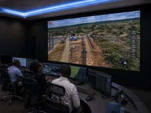
Real-Time Livestreaming to Remote Command Centres
Every second of flight transmits live to authorised stakeholders through a secure, encrypted drone livestreaming platform. As a result, security managers, asset protection teams, and executive leadership no longer wait for post-flight reports. They watch the pipeline in real time from command centres in Lagos, Port Harcourt, or anywhere in the world. When a threat develops, the decision-making window shrinks to minutes, not hours.
AI Threat Detection and Anomaly Identification
This is where the technology makes its most significant leap beyond conventional surveillance. AI-powered analytics engines continuously process the live drone feed, scanning for patterns that indicate criminal activity or infrastructure failure. The system automatically flags the following:
- Unauthorised human activity within the pipeline right-of-way
- Vehicle movements inconsistent with authorised operations
- Heat anomalies that may indicate a spill, fire, or illegal refining activity
- Physical changes to the pipeline corridor — fresh excavation, disturbed vegetation, or new structures
- Smoke or hydrocarbon vapour signatures associated with bunkering operations
When the AI detects an anomaly, it triggers an instant alert. The system routes the live feed to the relevant response team, along with GPS coordinates, a timestamp, and a visual record of the event. Human operators then assess the situation and coordinate a targeted response — all without stepping foot in the field.
Geoinfotech: Nigeria’s Leading Drone Surveillance Provider for Pipeline Protection
Deploying drone surveillance at the scale required to protect Nigeria’s pipeline network demands more than equipment. It requires local operational expertise, rigorous regulatory compliance, and a proven track record in high-stakes environments. Geoinfotech is the trusted partner for energy companies and government agencies across the country.
Full NCAA and ONSA Certification
Geoinfotech holds official operational clearance from the Nigerian Civil Aviation Authority (NCAA) and the Office of the National Security Adviser (ONSA). Our End-User Certificates and vetted flight access are fully established, enabling immediate deployment without delays. Every mission we conduct is legally compliant, fully documented, and operationally secure.
Industrial-Grade EO/IR Drone Platforms
Our pipeline surveillance missions use enterprise-class UAVs with dual electro-optical and infrared sensor payloads. These platforms deliver simultaneous high-definition visual and thermal feeds. Consequently, operators detect both visible activity and heat-signature anomalies in a single pass. No single-sensor platform can match that level of coverage.
Secure Encrypted Livestreaming Infrastructure
Every Geoinfotech drone surveillance operation transmits live, AES-256 encrypted video feeds directly to your command centre or mobile device. Our network bonding technology combines multiple cellular and satellite signals. This maintains a stable, high-definition stream even in the low-connectivity environments typical of remote pipeline corridors. Authorised stakeholders anywhere in the world access the live feed through secure multi-viewer links.
Nationwide Deployment Capability
Whether your operations require drone security surveillance in Lagos, pipeline monitoring drones in Port Harcourt, or rapid-response deployments across the Niger Delta, Geoinfotech maintains certified crews and logistical infrastructure to operate anywhere in Nigeria. Our nationwide footprint ensures that distance is never a barrier to protecting your assets.
Frequently Asked Questions
Q1: Can drones actually prevent pipeline vandalism, or do they only detect it after the fact?
When integrated with AI threat detection and real-time livestreaming, drones function as both a proactive deterrent and a detection tool. AI algorithms identify suspicious activity before vandals reach the pipe. They flag unauthorised vehicles, individuals, or equipment approaching a right-of-way and trigger an alert while there is still time to intercept. In addition, the visible presence of active drone surveillance deters would-be vandals.
Q2: How does thermal imaging help with pipeline surveillance?
Thermal cameras detect heat signatures that standard optical cameras cannot see. This is critical for pipeline surveillance because illegal bunkering operations generate significant heat from makeshift refining equipment. Thermal imaging also detects hydrocarbon spills, which carry a different thermal profile from the surrounding environment. Moreover, it identifies human presence at night or in dense vegetation where optical cameras fail.
Q3: What connectivity infrastructure does live drone feed support require in remote pipeline areas?
Geoinfotech uses advanced network bonding technology to combine multiple cellular networks and satellite connections into a single, stable transmission channel. Therefore, reliable high-definition livestreaming is achievable even in areas with poor individual network coverage. Our teams assess connectivity conditions during mission planning and configure the optimal transmission architecture for each deployment location.
Q4: Is drone surveillance for pipelines legally permitted in Nigeria?
Yes, with the appropriate regulatory clearances. Commercial drone operations in Nigeria require NCAA authorisation. Operations over sensitive infrastructure require additional ONSA vetting. Geoinfotech holds all required certifications and clearances. As a result, our clients benefit from fully compliant operations without navigating the regulatory process themselves. We handle all permitting, airspace coordination, and compliance documentation as part of every deployment.
Q5: Can the drone surveillance system integrate with our existing security infrastructure?
Yes. Geoinfotech’s drone surveillance platform complements and integrates with existing security operations centres, SCADA systems, and incident management platforms. Live feeds and AI-generated alerts route directly into your existing command infrastructure. Your security team then manages drone surveillance alongside all other operational data through a unified interface.
Protect Your Pipeline Infrastructure with Geoinfotech
Pipeline vandalism will not stop on its own. However, with AI-powered drone surveillance, energy operators in Nigeria now have the tools to detect threats earlier, respond faster, and protect their assets more effectively than ever before. Geoinfotech brings together certified UAV operations, enterprise-grade sensor payloads, encrypted livestreaming infrastructure, and AI-driven analytics into a single, end-to-end pipeline protection capability.
Whether you need continuous corridor monitoring, rapid-response aerial assessment, or a fully integrated drone surveillance programme, Geoinfotech has the expertise, the equipment, and the operational clearances to deploy immediately across Nigeria.
Contact Geoinfotech today to discuss how our drone livestreaming and AI surveillance solutions can secure your pipeline infrastructure.