
Where to Buy DJI Avata FPV Drone Fly Smart Combo in Lagos, Nigeria (2026 Guide)
Looking for where to buy the DJI Avata FPV Drone Fly Smart Combo in Lagos, Nigeria? This guide explains its features, key benefits, real-world applications, and the most reliable place to purchase an authentic unit with a warranty and support.
Introduction
The DJI Avata FPV Drone Fly Smart Combo has transformed immersive drone flying with its compact design, safety features, and cinematic performance. Whether you’re a content creator, real estate professional, or drone enthusiast in Nigeria, the Avata delivers an unmatched first-person view (FPV) experience.
Search interest is rapidly growing for:
- Where to buy the DJI Avata Fly Smart Combo in Nigeria
- Where to buy the DJI Avata Fly Smart Combo in Lagos
- Where to buy a DJI Avata FPV drone near me
- How to get the DJI Avata Fly Smart Combo in Nigeria
Choosing a trusted supplier ensures you get genuine equipment, proper support, and optimal performance.
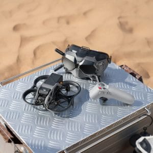
What is the DJI Avata Fly Smart Combo?
The DJI Avata is a cinewhoop-style FPV drone designed for stable, high-quality video capture—even in tight or indoor environments. The Fly Smart Combo includes everything needed for an immersive flight experience.
What’s Included in the Combo
- DJI Avata Drone – Compact design with built-in propeller guards for safety
- DJI FPV Goggles V2 – High-definition, low-latency video transmission
- DJI Motion Controller – Intuitive control using hand movements
This combination makes FPV flying accessible for beginners while still being powerful enough for professionals.
Why the DJI Avata is Ideal for Lagos
Urban Maneuverability
Lagos features dense infrastructure and busy environments. The Avata’s compact size allows smooth navigation through tight spaces and construction zones.
Built-in Safety
Integrated propeller guards help reduce damage from collisions—perfect for indoor flights and crowded urban areas.
High-Quality Imaging
Capture sharp, cinematic footage of Lagos’s skyline, coastal regions, and fast-growing developments.
Key Applications in Nigeria
Real Estate & Construction
- Create immersive property tours
- Monitor construction progress
- Analyze land and infrastructure
Creative Media (Nollywood & Content Creation)
- Capture dynamic FPV cinematic shots
- Produce engaging music videos and films
- Shoot high-speed action sequences
Security & Surveillance
- Real-time monitoring of large facilities
- Quick-response aerial inspections
- Situational awareness with FPV feed
Agriculture
- Monitor farmland and crop conditions
- Analyze layouts and irrigation patterns
Why Buying from a Trusted Dealer Matters
When searching for where to buy the DJI Avata Fly Smart Combo in Nigeria, choosing a reliable vendor is essential.
Benefits of Buying from a Verified Supplier
- Guaranteed authentic DJI products
- Manufacturer-backed warranty
- Local technical support
- Region-compatible firmware and settings
- Ready-to-fly setup out of the box
Avoid unauthorized sellers to prevent issues with performance, compatibility, and after-sales support.
Where to Buy the DJI Avata FPV Drone Fly Smart Combo in Lagos, Nigeria
If you’re searching for a reliable place to buy the DJI Avata Fly Smart Combo in Lagos or anywhere in Nigeria, GeoStore is a trusted provider of professional drone solutions.
Why Choose GeoStore?
- Authentic DJI drones and accessories
- Nationwide delivery across Nigeria
- Expert consultation and support
- Access to professional drone and mapping tools
GeoStore ensures you receive high-quality, ready-to-use equipment tailored to your needs.
Conclusion
The DJI Avata FPV Drone Fly Smart Combo is a powerful and versatile drone for creators, professionals, and organizations in Nigeria. Its immersive FPV system, compact design, and high-quality imaging make it ideal for a wide range of applications.
If you’re looking for where to buy the DJI Avata Fly Smart Combo in Lagos, GeoStore remains a reliable destination for genuine products, expert support, and seamless delivery.
FAQs
What is the DJI Avata Fly Smart Combo?
It is a bundle that includes the DJI Avata drone, DJI FPV Goggles V2, and the DJI Motion Controller.
Where can I buy the DJI Avata Fly Smart Combo in Lagos?
You can purchase authentic units from GeoStore.
Is the DJI Avata suitable for beginners?
Yes, its motion controller and safety features make it beginner-friendly.
What is the DJI Avata mainly used for?
It is used for cinematic video, real estate, inspections, security, and creative media production.


