
Operational monitoring of critical infrastructure such as oil pipelines, wellheads, and remote assets, requires timely and continuous visibility. Historically, traditional inspection methods have relied heavily on periodic field visits, which are severely limited by difficult accessibility, high costs, and delayed response times.
While drone technology has significantly improved data acquisition across Nigeria, a key limitation has remained: most workflows still focus on post-flight data processing rather than providing immediate, real-time situational awareness. This creates dangerous delays between observation and decision-making, which is particularly risky in high-risk environments.
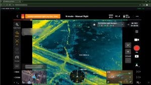
To bridge this crucial gap, GEOSTORE has integrated a real-time drone streaming system designed to enable continuous remote access to live aerial feeds.
The Challenge: Visibility in Remote Environments
Infrastructure monitoring in remote or sensitive environments presents several major challenges:
- Limited real-time visibility of active field operations.
- A heavy dependence on having physical access to the actual drone controllers.
- Costly delays in identifying incidents or anomalies during inspections.
- Inefficient collaboration between on-site field teams and remote stakeholders.
- A lack of a centralized monitoring interface.
The operational impact of these challenges is substantial. It leads to slower incident response times , reduced oversight during active drone missions , and increased operational risk when monitoring critical pipelines and assets. Furthermore, communication between teams becomes fragmented. A system was urgently required to stream drone feeds securely and in real time, making them accessible over a network without relying on direct hardware connections.
The GEOSTORE Solution: Seamless, Browser-Based Streaming
GEOSTORE’s system was designed as a lightweight streaming pipeline that features straightforward browser-based access. By tapping directly into the live video feed from a DJI drone controller , the system provides a browser-based interface for monitoring drone operations without requiring physical proximity to the controller.
Key System Deliverables:
- Live Video Streaming: Experience a real-time drone feed accessible directly via your web browser. The system guarantees low-latency transmission for the accurate monitoring of live operations.
- True Remote Accessibility: Stakeholders have the ability to view the drone feed from any authorized device. There is absolutely no need for physical access to the controller.
- Wireless Operation: Enjoy a fully wireless setup without USB dependency. It maintains a stable connection over local or mesh networks.
- Enhanced Operational Monitoring: The platform enables the continuous observation of pipeline routes, facilities, and physical assets. This leads to vastly improved coordination between field operators and remote teams.
Delivering Impact and Value
From a technical perspective, GEOSTORE demonstrates how real-time streaming can be seamlessly integrated into existing drone workflows without the need for complex infrastructure or proprietary systems.
This system drastically enhances operational workflows in drone-based monitoring:
- Provides immediate visibility into field operations.
- Enables the faster identification of anomalies or security incidents.
- Reduces the need for excess personnel at hazardous site locations.
- Improves collaboration across distributed teams, whether they are in a Lagos boardroom or on-site.
- Lowers overall operational friction through an efficient wireless setup.
Conclusion
GEOSTORE’s real-time drone streaming system effectively bridges the gap between data acquisition and active decision-making in infrastructure monitoring. By enabling live access to aerial feeds through a simple browser-based interface, this solution transforms drone operations from isolated field activities into connected, observable workflows.
Looking ahead, the system can be extended to include video recording, analytics overlays, and integration with geospatial dashboards such as GGIS, creating a fully unified platform for both live monitoring and post-processing analysis.


