Revolutionizing Mineral Prospectivity Mapping in Nigeria Using Google Earth Engine | Geostore
Nigeria’s mining sector is brimming with untapped potential. However, uncovering these valuable resources has historically been a demanding process. Mineral exploration in Nigeria has traditionally relied on field surveys, localized studies, and legacy geological maps. While these methods are effective, they are often difficult to scale across large regions, spatially limited, and time-intensive. At Geostore, we understand that modern mining requires modern solutions. With the rise of cloud-based geospatial platforms like Google Earth Engine (GEE) and the increasing availability of satellite imagery, there is a massive opportunity to turn mineral exploration into a scalable, data-driven process.
Here is a look at how interactive, satellite-driven applications are changing the game for mineral prospectivity mapping in Nigeria.
The Challenges of Traditional Mineral Exploration
Before a single drill hits the ground, exploration teams face significant hurdles. Traditional mineral exploration workflows face several limitations, including:
- High time and cost requirements for field campaigns.
- Limited spatial coverage from traditional surveys.
- The difficulty of integrating multi-source geospatial datasets.
- A widespread lack of accessible tools for rapid prospectivity screening.
- Heavy dependence on static reports and maps.
These limitations have real operational implications. They lead to the delayed identification of viable exploration targets and the inefficient allocation of vital exploration resources. Furthermore, they reduce the ability of exploration teams to perform preliminary screening at scale. The industry required a dynamic system that allows users to analyze mineral potential across regions using remote sensing, without needing advanced GIS infrastructure.
The Geostore Edge: Data-Driven Prospectivity Mapping
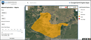
To meet these challenges head-on, an interactive mineral exploration application was developed within Google Earth Engine using a structured analytical workflow. This tool enables the rapid identification of potential mineral zones across Nigeria through terrain analysis and satellite-derived spectral indices.
1. Targeted Area and Mineral Selection
The application allows for the user-driven selection of specific regions of interest. It uses administrative boundaries at the state and Local Government Area (LGA) levels, sourced from GAUL datasets. Users can target predefined mineral categories crucial to Nigeria’s economy, including:
- Gold
- Iron Ore
- Limestone
- Clay / Kaolin
- Bauxite
- Tin / Columbite. Each of these minerals is directly linked to appropriate datasets and spectral indicators.
2. High-Fidelity Data Sources and Spectral Analysis
The backbone of this application is its reliance on robust, multi-source data:
- Sentinel-2: Used for high-resolution multispectral analysis.
- ASTER: Utilized for SWIR-based mineral detection.
- SRTM: Applied for terrain-derived parameters, such as slope.
To ensure accuracy, the system applies temporal filtering, including cloud masking, to improve data quality and a user-defined date range for Sentinel-2 imagery. Band ratio techniques are then applied for mineral detection, utilizing indicators like iron oxide indices, hydroxyl alteration indicators, carbonate detection ratios, and Al-OH spectral signatures.
3. Clear Classification and Visualization
Raw data is transformed into actionable intelligence. Continuous spectral outputs are normalized and reclassified into five distinct prospectivity levels:
- Very Low
- Low
- Moderate
- High
- Very High
The system provides multi-color classified maps using intuitive color gradients, overlaid with selected administrative boundaries. This workflow is fully interactive and executed on demand directly within the GEE environment.
Key Outputs for Geospatial Professionals
By leveraging this application, users generate powerful outputs designed to streamline the exploration phase:
- Mineral Prospectivity Maps: Classified maps that show mineral potential levels with clear visual differentiation between low and high potential zones.
- Interactive Analysis: Users can select specific states and LGAs and receive real-time updates of analysis results.
- Dataset Visualization: Provides RGB composites of ASTER and Sentinel-2 imagery for a contextual understanding of surface features and terrain.
- Dynamic Legends & Referencing: Automatically generated classification legends ensure standardized interpretation, supported by built-in scientific references backing the methodology.
Impact and Value: Why It Matters
From a technical standpoint, this application proves the effectiveness of combining cloud computing and spectral analysis for geoscience applications. But practically, it introduces a highly scalable approach to mineral exploration. The primary benefits include:
- Rapid screening of large geographic areas across Nigeria.
- Significant reduction in preliminary exploration costs.
- Vastly improved targeting for actual field investigations.
- Seamless integration of multiple datasets into one unified workflow.
- High accessibility for users who do not have advanced GIS setups.
The Future of Nigerian Mineral Exploration
This Mineral Exploration GEE Application offers a highly practical framework for leveraging satellite data during early-stage exploration. By synthesizing terrain analysis, interactive visualization, and spectral indices, the system empowers teams to efficiently identify potential mineral zones across the country. Looking ahead, this platform can easily be extended. By incorporating additional datasets—such as geochemical data, geophysical surveys, and machine learning-based prediction models—it can be further enhanced as a premier decision-support tool for mineral exploration.