Document

Precision Agriculture

We work with precision and accuracy

The science of enhancing agricultural yields and supporting management choices with advanced sensor and analysis technologies is known as precision agriculture, or PA. The world has embraced PA, a novel idea that promises to boost output, cut down on labor costs, and guarantee efficient management of irrigation and fertilizer systems. It makes use of a lot of data and information to enhance crop quality, yields, and the utilization of agricultural resources (Mulla, 2013). The goal of PA, an agricultural innovation and optimized field level management method, is to increase resource production on agricultural fields. In order to improve productivity, quality, and yield, farmers use PA, a new and sophisticated technique, to deliver optimum inputs like water and fertilizer (Gebbers and Adamchuk, 2010). It needs an enormous amount of high spatial resolution data regarding the health or status of the crop during the growth season.

Precision Agriculture

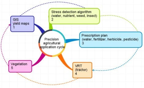
For many years, remote sensing has been hailed as a vital source of data to enable precision agriculture, but for a variety of reasons, uptake has been gradual. Advancements in technology, particularly the accessibility of high-resolution satellite imagery and the recent swift growth of unmanned aerial vehicle (UAV) technology, indicate that the use of remote sensing data sources in precision agriculture is anticipated to surge in the next ten years.

Multispectral data are typically used in satellite and unmanned aerial vehicle (UAV)-based precision agriculture remote sensing applications to estimate high-spatial resolution information about soil parameters, plant health, and crop yields. According to Ben-Dor et al. (2008), reflectance spectra from soils can reveal details about a range of soil characteristics, such as soil moisture and organic matter concentration. Certain elements that impact soil fertility and moisture holding capacity, such as clay minerals, calcium carbonates, and iron oxides, can also be quantified based on the spectral resolution of the apparatus (Thomasson et al., 2001; Rossel et al., 2006).

According to Ben-Dor (2002) and Ben-Dor et al. (2008), each of these soil constituents has distinct spectral regions where reflectance (or absorption) is strongest. To identify these soil constituents, narrowband or hyperspectral imagery is frequently needed in conjunction with methods like spectral unmixing algorithms (Huete and Escadafal, 1991) or derivative spectra (Demetriadesshah et al., 1990; Li et al., 1993).

What is Precision agriculture also called?

Other names for precision agriculture include as-needed farming, site-specific crop management, and precision farming (SSCM). Information technology is used in precision agriculture to make sure that the soil and crops receive precisely what they require for maximum health and yield. Profitability, sustainability, and environmental preservation are also guaranteed by this. When managing crops, it takes into account factors including plant development, soil type, terrain, weather, and yield data.

Precision Agriculture

BENEFITS OF PRECISION AGRICULTURE IN NIGERIA

  1. Farmers can receive recommendations regarding crop rotation, the best times to sow and harvest crops, and how to maintain the soil through the use of predictive analytics software.
  2. To help farmers identify fields that need to be treated and figure out how much water, fertilizer, and pesticide to use, agricultural control centers can combine sensor data and imagery input with other data.
  3. This lowers expenses and manages the farm’s environmental effect while assisting the farmer in preventing runoff and squandering resources and making sure the soil has the ideal amount of additives for maximum health.
  4. Precision farming reduces variability in net returns by offering site-specific management that can identify issues with growth conditions.
  5. Chemical and fertilizer applications carried out with precision will better meet crop needs and avoid over-application, which may have negative environmental effects. Good land stewardship will be encouraged by the management techniques produced by precision farming technologies.
  6. In challenging circumstances, farm tractor operators can increase field efficiency with GPS-based navigation devices. They can lessen overlap and improper input applications (like spraying), which can assist weary personnel in maintaining greater field efficiency.
  7. Precision farming technology will allow the additional control that is required when you are managing the production of differentiated products as opposed to the production of regular bulk crops.


Our Portfolio

Check out our previous projects on GIS, Drone, Land Surveyor and Mapping Services in Nigeria

Top 5 most violent states in Nigeria and their emergency centers

LAND USE/LAND COVER MAPPING AND ANALYSIS OF AKURE, NIGERIA

LAND USE/LAND COVER MAPPING AND ANALYSIS OF AKURE, NIGERIA

3D Diorama of the straits of Mackinac

 DETAILED AERIAL, LAND SURVEY AND GIS ANALYSIS FOR ADVANCED REAL ESTATE DEVELOPMENT

 DETAILED AERIAL, LAND SURVEY AND GIS ANALYSIS FOR ADVANCED REAL ESTATE DEVELOPMENT

Professional Drone Mapping and GIS Training For ETA-ZUMA Mining Company

Professional Drone Mapping and GIS Training For ETA-ZUMA Mining Company

Installation of Intelligent Traffic Lights

Installation of Intelligent Traffic Lights

Geological Report on a Mining/Exploration Survey

Geological Report on a Mining/Exploration Survey

Drone Survey and Mapping of Shaishen Foods Limited

Drone Survey and Mapping of Shaishen Foods Limited

Gold Site Suitability Analysis in North Africa

Gold Site Suitability Analysis in North Africa

Lidar Topographic Mapping Project

Lidar Topographic Mapping Project

Geophysical/hydrogeophysical Studies for Groundwater Development

Geophysical/hydrogeophysical Studies for Groundwater Development

Togo Digital Terrain Model Project

Togo Digital Terrain Model Project

Drone Mapping of Parts of Lome Rail Line for Graceland Energy Located at Lome Togo

Drone Mapping of Parts of Lome Rail Line for Graceland Energy Located at Lome Togo

Drone/land Survey of Pure-chem Industrial Limited, Ogun State.

Drone/land Survey of Pure-chem Industrial Limited, Ogun State.

Drone Inspection/survey of Southern Lake Estate, Chevron, Lekki, Lagos State

Drone Inspection/survey of Southern Lake Estate, Chevron, Lekki, Lagos State

Anniversary-Workshop on the Application of Remote Sensing and Drone Technology in GIS -Abuja

Anniversary-Workshop on the Application of Remote Sensing and Drone Technology in GIS -Abuja

Topographic Mapping of Oyo State

Topographic Mapping of Oyo State

Topographic Mapping of Part of the Local Government Areas in Oyo State

Topographic Mapping of Part of the Local Government Areas in Oyo State

Topographic Mapping of Part of Kwara, Ekiti and Kogi State Local Government Area

Topographic Mapping of Part of Kwara, Ekiti and Kogi State Local Government Area

Political Map of South West, Nigeria Located in Nigeria

Political Map of South West, Nigeria Located in Nigeria

Topographic Mapping of Parts of Niger State Located at Niger State, Nigeria

Topographic Mapping of Parts of Niger State Located at Niger State, Nigeria

Topographic Mapping of Part of Kwara, Ekiti, and Kogi State Local Government Area Located in Nigeria

Topographic Mapping of Part of Kwara, Ekiti, and Kogi State Local Government Area Located in Nigeria

Topographic Mapping of Part of Kwara State Local Government Area Located at Kwara State Nigeria

Topographic Mapping of Part of Kwara State Local Government Area Located at Kwara State Nigeria

Guide Map of Oshodi Transport Interchange Located in Lagos

Guide Map of Oshodi Transport Interchange Located in Lagos

Flood Analysis of Amuwo-odofin Orthophoto.

Flood Analysis of Amuwo-odofin Orthophoto.

Site Inspection Using Drone of Water Corporation Located at Oke-aro Agege

Site Inspection Using Drone of Water Corporation Located at Oke-aro Agege

24,000 meter Lome Rail Line for Drone Mapping, Graceland Energy Located at Lome, Togo

24,000 meter Lome Rail Line for Drone Mapping, Graceland Energy Located at Lome, Togo

10 Drone Inspection Traffic Signal in Lagos

10 Drone Inspection Traffic Signal in Lagos

Lagos October 1st Free GIS Training Workshop

Lagos October 1st Free GIS Training Workshop

Abuja GIS Training 12th of August 2022

Abuja GIS Training 12th of August 2022

Osun state parcel project

Osun state parcel project

Drone Mapping & Vectorization Of Abu-allied Farm

Drone Mapping & Vectorization Of Abu-allied Farm

Proposal for aerial deployment, tracking and monitoring of threats in victoria island phase 1 and ikoyi phase 2, nigeria

Proposal for aerial deployment, tracking and monitoring of threats in victoria island phase 1 and ikoyi phase 2, nigeria

Jabi Lake Mall Solar Inspection – Abuja

Jabi Lake Mall Solar Inspection – Abuja

Ground Control and Drone Survey for Mast 3D Modeling

Ground Control and Drone Survey for Mast 3D Modeling

Telecom Drone 3D and 2D Modeling of Cellsite

Telecom Drone 3D and 2D Modeling of Cellsite

Free GIS Spatial Analysis Training (Lagos Branch)

Free GIS Spatial Analysis Training (Lagos Branch)

800 Building Plots Aerial Capture and Delineation for Database. Greenfield Estate

800 Building Plots Aerial Capture and Delineation for Database. Greenfield Estate

100 Hectares Aerial Survey with Differential GPS of High Accuracy

100 Hectares Aerial Survey with Differential GPS of High Accuracy

Protected: Nigeria Crime Report and Dashboard

Protected: Nigeria Crime Report and Dashboard

Drone Survey and Mapping – Victoria Island  Copy

Drone Survey and Mapping – Victoria Island Copy

Akwa-Ibom 500 Hectares Drone Survey and Mapping in Nigeria

Akwa-Ibom 500 Hectares Drone Survey and Mapping in Nigeria

Ground Control Establishment – Republic of the Niger – Kano, Kastina, Jigawa, Kaduna

Ground Control Establishment – Republic of the Niger – Kano, Kastina, Jigawa, Kaduna

Drone Survey and Mapping – Victoria Island

Drone Survey and Mapping – Victoria Island

Control Point Establishment – DGPS

Control Point Establishment – DGPS

Land Survey – Northern Nigeria

Land Survey – Northern Nigeria

Biodiversity Mapping – Sweden

Biodiversity Mapping – Sweden

Flood Impact Mapping – United Kingdom

Flood Impact Mapping – United Kingdom

M and E GIS Dashboard for Control Establishment Project

M and E GIS Dashboard for Control Establishment Project

Geodatabase Management System Training For National Boundary Commission

Geodatabase Management System Training For National Boundary Commission

Nigeria Topographic Map – Project

Nigeria Topographic Map – Project

Abuja Training on Introduction to GIS

Abuja Training on Introduction to GIS

200 Hectares Land and Drone Survey – Lagos Nigeria

200 Hectares Land and Drone Survey – Lagos Nigeria

Inspection of 30 hectares drainage

Inspection of 30 hectares drainage

Drainage Drone Mapping and Surveying in Lagos Nigeria

Drainage Drone Mapping and Surveying in Lagos Nigeria

GIS Cadastral Mobile Application

GIS Cadastral Mobile Application

Abuja Topographical Map – HD GIS Mapping

Abuja Topographical Map – HD GIS Mapping

Ground Topography Survey (Lagos Island)

Ground Topography Survey (Lagos Island)

2.7km2 Topography Survey in Snake Island

2.7km2 Topography Survey in Snake Island

GIS Masterclass

GIS Masterclass

Sokoto Contour Map

Sokoto Contour Map

NDVI Vegetation Assessment in Lagos State

NDVI Vegetation Assessment in Lagos State

Lagos drone training master class

Lagos drone training master class

Ifako drone topographic survey and mapping

Ifako drone topographic survey and mapping

CMD Lagos 3D mapping aerial modeling

CMD Lagos 3D mapping aerial modeling

GIS and Drone Masterclass

GIS and Drone Masterclass

Drone aerial survey and mapping – Lagos Island _ Somolu

Drone aerial survey and mapping – Lagos Island _ Somolu

Drone Pilot Mapping and Aerial Photography

Drone Pilot Mapping and Aerial Photography

AutoCAD Mapping and Surveying

AutoCAD Mapping and Surveying

Mapping with GIS for Maritime Boundary

Mapping with GIS for Maritime Boundary

GIS for Maritime using ArcGIS and QGIS

GIS for Maritime using ArcGIS and QGIS

Migrating from ArcMap to ArcGIS Pro

Migrating from ArcMap to ArcGIS Pro

Getting started with Web Mapping using ArcGIS

Getting started with Web Mapping using ArcGIS

Geographic Information System – Python, SQL, DBMS

Geographic Information System – Python, SQL, DBMS

Introduction to GIS [NYSC Special]

Introduction to GIS [NYSC Special]

Drone Photography and Videography

Drone Photography and Videography

Introduction to GIS

Introduction to GIS

Drone Training for Beginners

Drone Training for Beginners

Covid-19 | Nigeria Data Visualisation

Covid-19 | Nigeria Data Visualisation

Benue Flood Analysis

Benue Flood Analysis

Aerial photography Ile-Ife Osun State

Aerial photography Ile-Ife Osun State

Kenya Forest Project

Kenya Forest Project

Tunsun Consultants Ltd

Tunsun Consultants Ltd

Introduction To Gis In Maritime at the National Boundary Commission

Introduction To Gis In Maritime at the National Boundary Commission

Training on GIS and Drone Mapping (batch-4 & 5)

Training on GIS and Drone Mapping (batch-4 & 5)

Osun Flood Mapping

Osun Flood Mapping

Lahass International Limited

Lahass International Limited

Linguistic Association of Nigeria

Linguistic Association of Nigeria

West African Indexing Services

West African Indexing Services

Lagos Ikeja Road Network Map

Lagos Ikeja Road Network Map

LASU Land Regularisation Portal

LASU Land Regularisation Portal

Lingua Plus International

Lingua Plus International

Lagferry Web Route

Lagferry Web Route

YOU MAY ALSO LIKE...