Document

A topographic survey is a detailed mapping process that captures the natural and artificial features of land, including elevations, contours, slopes, drainage patterns, vegetation, buildings, and utilities. It is one of the most fundamental preliminary steps in modern construction projects because it provides accurate spatial data that guides planning, design, execution, and management. In modern construction where precision, safety, sustainability, and cost-efficiency are essential, topographic surveys serve as the foundation for informed decision-making throughout the project lifecycle. A practical example of topographic survey is clearly depicted in Figure 1. In contemporary construction where projects are increasingly complex, technology-driven, and sustainability focused topographic surveys are indispensable tools for ensuring safety, accuracy, cost-efficiency, and regulatory compliance.

  1. Key Reasons Topographic Surveys are Critical
  2. 2.1 Accurate Planning and Design: Topographic surveys provide precise measurements of terrain, enabling engineers and architects to develop realistic and effective designs. These surveys help project teams understand site conditions before construction begins.
  • They show contours, elevations, and natural features clearly.
  • They help determine building orientation and placement.
  • They allow engineers to design foundations that fit the terrain.

Accurate site information reduces errors in design and ensures that structures align properly with real-world conditions.

  1. 2.2 Identification of Site Constraints and Opportunities: Topographic surveys reveal both challenges and advantages of a site. They help detect the uneven terrain and slopes, drainage patterns, soil instability and existing infrastructure and utilities. Early detection allows planners to modify designs to suit the land, avoiding impractical plans and costly redesigns later. Figure 1 is an example of uneven terrain and slope under survey which the result could help in prevention of challenges during construction and after project implementation. Figure 2 is a contour or result of topographic survey of a land.

\

Figure 1: Topographic Survey of uneven Terrain and Slope

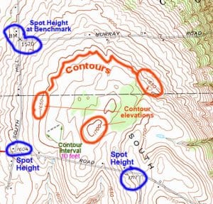
Figure: 2 Contour of an Area

  1. 2.3 Risk Reduction and Safety Enhancement: Construction projects involve numerous risks, including structural failures, flooding, and accidents. Topographic surveys help mitigate these risks by identifying potential hazards such as: flood-prone areas, landslide-susceptible slopes, underground utilities and unsafe ground conditions. By addressing these risks early, project teams can implement safety measures and avoid accidents.
  2. 2.4 Cost Savings and Budget Control: One of the most significant benefits of topographic surveys is cost efficiency. They help prevent: design errors, rework during construction, unexpected excavation costs, and material wastage. Accurate data also enables precise calculation of earthwork volumes and material requirements, improving financial planning.
  • 2.5 Legal Compliance and Regulatory Approval: In many countries, topographic surveys are mandatory before construction approval. They ensure compliance with: zoning regulations, environmental laws, building codes and land-use policies. Accurate surveys facilitate faster approvals and reduce legal disputes.
  1. 2.6 Efficient Construction Management: Topographic surveys support better coordination during project execution by helping contractors: plan machinery placement, optimize construction sequences, establish control points, and monitor progress accurately. This improves workflow efficiency and reduces project delays.
  2. 2.7 Infrastructure and Utility Planning: For large projects such as highways, bridges, and pipelines, topographic surveys provide essential data for: grading and leveling, drainage system design, utility alignment and transportation route planning. These surveys ensure infrastructure stability and functionality.
  3. 2.8 Environmental Sustainability: Modern construction emphasizes environmental protection. Topographic surveys help developers: preserve natural features, avoid ecologically sensitive areas, manage water runoff, and minimize environmental impact. This supports sustainable and responsible land development.
  4. Importance in the Modern Construction Era

Topographic surveys have become even more critical today due to technological advancements such as GPS and GNSS surveying, drone mapping, LiDAR scanning and digital terrain modeling. These technologies provide highly accurate 3D representations of terrain, improving planning precision and project outcomes. Topographic surveys are essential for designing stable foundations and safe structures as shown in Figure 3.

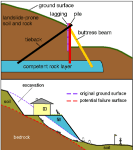
Figure 3: Designing stable foundations and safe structures Identification of Land through Topographic Survey Information

Topographic surveys are essential for designing stable foundations and safe structures. They identify unstable slopes and soil conditions, they reveal flood-prone areas and erosion risks and they help engineers determine safe building locations. Understanding land slope and stability ensures structures are designed safely and reduces the risk of structural failure.

Financial benefits Topographic Survey

Topographic surveys play a major role in minimizing construction costs. For example, accurate earthwork calculations (cut and fill volumes), reduced rework due to design errors, better material estimation, efficient resource allocation and precise terrain data helps avoid expensive surprises and improves financial planning throughout construction.

Figure 4: Identified Equipment required for construction through topographic survey

  1. Consequences of Not Conducting Topographic Surveys

Failure to conduct a topographic survey may lead to structural instability, project delays, legal disputes, increased costs and safety hazards. Inaccurate terrain data can result in foundation errors, misalignment, and construction failure.

  1. Conclusion

Topographic surveys are indispensable in modern construction projects because they provide accurate, reliable, and comprehensive information about land characteristics. Topographic surveys are the backbone of modern construction projects. Without this type of survey, construction projects would face increased risks, inefficiencies, and uncertainties. As construction continues to evolve with advanced technologies and sustainability demands, the importance of topographic surveys will only continue to grow. They provide accurate, reliable, and comprehensive spatial data that supports planning, design, safety, cost management, environmental sustainability, and regulatory compliance. They support effective planning, risk management, cost control, regulatory compliance, environmental sustainability, and project efficiency. Without topographic surveys, construction projects would rely on assumptions rather than precise data, significantly increasing the likelihood of failure, delays, and financial losses.


RECENT ACTIVITIES AND PROJECT...

URABN HEAT ISLAND EFFECT IN CALABAR MUNICIPAL

URABN HEAT ISLAND EFFECT IN CALABAR MUNICIPAL

ANALYZING URBANIZATION TRENDS IN KANO STATE, NIGERIA USING NIGHTTIME LIGHTS REMOTE SENSING DATA

ANALYZING URBANIZATION TRENDS IN KANO STATE, NIGERIA USING NIGHTTIME LIGHTS REMOTE SENSING DATA

COMPREHENSIVE OFFSHORE SURVEILLANCE AND MARITIME INFRASTRUCTURE MONITORING

COMPREHENSIVE OFFSHORE SURVEILLANCE AND MARITIME INFRASTRUCTURE MONITORING

Comprehensive Aerial Survey and Mapping for Golf Course Asset Management at Lakowe Golf Lake

Comprehensive Aerial Survey and Mapping for Golf Course Asset Management at Lakowe Golf Lake

Professional Drone Training Program for Enhanced Corporate Security Operations at Sahara Group

Professional Drone Training Program for Enhanced Corporate Security Operations at Sahara Group

Advanced Aerial Topographic Survey and Mapping for Land Development in Ogun State

Advanced Aerial Topographic Survey and Mapping for Land Development in Ogun State

Precision RGB and Thermal Imaging Revolutionizes Solar Infrastructure Inspection In Enugu

Precision RGB and Thermal Imaging Revolutionizes Solar Infrastructure Inspection In Enugu

Advanced Drone-Based Topographic Survey for Precision Land Development Planning

Advanced Drone-Based Topographic Survey for Precision Land Development Planning

Mapping the Future: Comprehensive Area Survey Transforms Land Development in Akure

Mapping the Future: Comprehensive Area Survey Transforms Land Development in Akure

Precision Topographical Survey and Mapping for Smarter Infrastructure Planning

Precision Topographical Survey and Mapping for Smarter Infrastructure Planning

Precision Drone Volumetric Surveys: How Purechem Industries Optimized Mineral Stockpile Management

Precision Drone Volumetric Surveys: How Purechem Industries Optimized Mineral Stockpile Management

Advanced Mapping & Environmental Survey for Ilubirin Property, Lagos Island

Advanced Mapping & Environmental Survey for Ilubirin Property, Lagos Island

Unveiling the Invisible: LiDAR Technology Transforms Terrain Analysis in Abeokuta North

Unveiling the Invisible: LiDAR Technology Transforms Terrain Analysis in Abeokuta North

 DETAILED AERIAL, LAND SURVEY AND GIS ANALYSIS FOR ADVANCED REAL ESTATE DEVELOPMENT

 DETAILED AERIAL, LAND SURVEY AND GIS ANALYSIS FOR ADVANCED REAL ESTATE DEVELOPMENT

Professional Drone Mapping and GIS Training For ETA-ZUMA Mining Company

Professional Drone Mapping and GIS Training For ETA-ZUMA Mining Company

Installation of Intelligent Traffic Lights

Installation of Intelligent Traffic Lights

Geological Report on a Mining/Exploration Survey

Geological Report on a Mining/Exploration Survey

Drone Survey and Mapping of Shaishen Foods Limited

Drone Survey and Mapping of Shaishen Foods Limited

Lidar Topographic Mapping Project

Lidar Topographic Mapping Project

Geophysical/hydrogeophysical Studies for Groundwater Development

Geophysical/hydrogeophysical Studies for Groundwater Development

Togo Digital Terrain Model Project

Togo Digital Terrain Model Project

Drone Mapping of Parts of Lome Rail Line for Graceland Energy Located at Lome Togo

Drone Mapping of Parts of Lome Rail Line for Graceland Energy Located at Lome Togo

Drone/land Survey of Pure-chem Industrial Limited, Ogun State.

Drone/land Survey of Pure-chem Industrial Limited, Ogun State.

Drone Inspection/survey of Southern Lake Estate, Chevron, Lekki, Lagos State

Drone Inspection/survey of Southern Lake Estate, Chevron, Lekki, Lagos State

Anniversary-Workshop on the Application of Remote Sensing and Drone Technology in GIS -Abuja

Anniversary-Workshop on the Application of Remote Sensing and Drone Technology in GIS -Abuja

Topographic Mapping of Oyo State

Topographic Mapping of Oyo State

Topographic Mapping of Part of the Local Government Areas in Oyo State

Topographic Mapping of Part of the Local Government Areas in Oyo State

Topographic Mapping of Part of Kwara, Ekiti and Kogi State Local Government Area

Topographic Mapping of Part of Kwara, Ekiti and Kogi State Local Government Area

Political Map of South West, Nigeria Located in Nigeria

Political Map of South West, Nigeria Located in Nigeria

Topographic Mapping of Parts of Niger State Located at Niger State, Nigeria

Topographic Mapping of Parts of Niger State Located at Niger State, Nigeria

Topographic Mapping of Part of Kwara, Ekiti, and Kogi State Local Government Area Located in Nigeria

Topographic Mapping of Part of Kwara, Ekiti, and Kogi State Local Government Area Located in Nigeria

Topographic Mapping of Part of Kwara State Local Government Area Located at Kwara State Nigeria

Topographic Mapping of Part of Kwara State Local Government Area Located at Kwara State Nigeria

Flood Analysis of Amuwo-odofin Orthophoto.

Flood Analysis of Amuwo-odofin Orthophoto.

Site Inspection Using Drone of Water Corporation Located at Oke-aro Agege

Site Inspection Using Drone of Water Corporation Located at Oke-aro Agege

24,000 meter Lome Rail Line for Drone Mapping, Graceland Energy Located at Lome, Togo

24,000 meter Lome Rail Line for Drone Mapping, Graceland Energy Located at Lome, Togo

10 Drone Inspection Traffic Signal in Lagos

10 Drone Inspection Traffic Signal in Lagos

Lagos October 1st Free GIS Training Workshop

Lagos October 1st Free GIS Training Workshop

Osun state parcel project

Osun state parcel project

Drone Mapping & Vectorization Of Abu-allied Farm

Drone Mapping & Vectorization Of Abu-allied Farm

Proposal for aerial deployment, tracking and monitoring of threats in victoria island phase 1 and ikoyi phase 2, nigeria

Proposal for aerial deployment, tracking and monitoring of threats in victoria island phase 1 and ikoyi phase 2, nigeria

Jabi Lake Mall Solar Inspection – Abuja

Jabi Lake Mall Solar Inspection – Abuja

Ground Control and Drone Survey for Mast 3D Modeling

Ground Control and Drone Survey for Mast 3D Modeling

Telecom Drone 3D and 2D Modeling of Cellsite

Telecom Drone 3D and 2D Modeling of Cellsite

Free GIS Spatial Analysis Training (Lagos Branch)

Free GIS Spatial Analysis Training (Lagos Branch)

800 Building Plots Aerial Capture and Delineation for Database. Greenfield Estate

800 Building Plots Aerial Capture and Delineation for Database. Greenfield Estate

100 Hectares Aerial Survey with Differential GPS of High Accuracy

100 Hectares Aerial Survey with Differential GPS of High Accuracy

Protected: Nigeria Crime Report and Dashboard

Protected: Nigeria Crime Report and Dashboard

Drone Survey and Mapping – Victoria Island  Copy

Drone Survey and Mapping – Victoria Island Copy

Akwa-Ibom 500 Hectares Drone Survey and Mapping in Nigeria

Akwa-Ibom 500 Hectares Drone Survey and Mapping in Nigeria

Ground Control Establishment – Republic of the Niger – Kano, Kastina, Jigawa, Kaduna

Ground Control Establishment – Republic of the Niger – Kano, Kastina, Jigawa, Kaduna

Drone Survey and Mapping – Victoria Island

Drone Survey and Mapping – Victoria Island

Control Point Establishment – DGPS

Control Point Establishment – DGPS

Land Survey – Northern Nigeria

Land Survey – Northern Nigeria

Biodiversity Mapping – Sweden

Biodiversity Mapping – Sweden

Flood Impact Mapping – United Kingdom

Flood Impact Mapping – United Kingdom

M and E GIS Dashboard for Control Establishment Project

M and E GIS Dashboard for Control Establishment Project

Geodatabase Management System Training For National Boundary Commission

Geodatabase Management System Training For National Boundary Commission

Nigeria Topographic Map – Project

Nigeria Topographic Map – Project

Abuja Training on Introduction to GIS

Abuja Training on Introduction to GIS

200 Hectares Land and Drone Survey – Lagos Nigeria

200 Hectares Land and Drone Survey – Lagos Nigeria

Inspection of 30 hectares drainage

Inspection of 30 hectares drainage

Drainage Drone Mapping and Surveying in Lagos Nigeria

Drainage Drone Mapping and Surveying in Lagos Nigeria

GIS Cadastral Mobile Application

GIS Cadastral Mobile Application

Abuja Topographical Map – HD GIS Mapping

Abuja Topographical Map – HD GIS Mapping

Ground Topography Survey (Lagos Island)

Ground Topography Survey (Lagos Island)

2.7km2 Topography Survey in Snake Island

2.7km2 Topography Survey in Snake Island

GIS Masterclass

GIS Masterclass

Sokoto Contour Map

Sokoto Contour Map

NDVI Vegetation Assessment in Lagos State

NDVI Vegetation Assessment in Lagos State

Lagos drone training master class

Lagos drone training master class

Ifako drone topographic survey and mapping

Ifako drone topographic survey and mapping

CMD Lagos 3D mapping aerial modeling

CMD Lagos 3D mapping aerial modeling

GIS and Drone Masterclass

GIS and Drone Masterclass

Drone aerial survey and mapping – Lagos Island _ Somolu

Drone aerial survey and mapping – Lagos Island _ Somolu

Covid-19 | Nigeria Data Visualisation

Covid-19 | Nigeria Data Visualisation

Benue Flood Analysis

Benue Flood Analysis

Aerial photography Ile-Ife Osun State

Aerial photography Ile-Ife Osun State

Kenya Forest Project

Kenya Forest Project

Tunsun Consultants Ltd

Tunsun Consultants Ltd

Introduction To Gis In Maritime at the National Boundary Commission

Introduction To Gis In Maritime at the National Boundary Commission

Training on GIS and Drone Mapping (batch-4 & 5)

Training on GIS and Drone Mapping (batch-4 & 5)

Osun Flood Mapping

Osun Flood Mapping

Lahass International Limited

Lahass International Limited

Linguistic Association of Nigeria

Linguistic Association of Nigeria

West African Indexing Services

West African Indexing Services

Lagos Ikeja Road Network Map

Lagos Ikeja Road Network Map

LASU Land Regularisation Portal

LASU Land Regularisation Portal

Lingua Plus International

Lingua Plus International

Lagferry Web Route

Lagferry Web Route

YOU MAY ALSO LIKE...

COURSES

Explore Geoinfotech courses and establish a strong foundation of knowledge and skills to be productive with the latest Technology.

[Beginners to Professional] short training program

Our professional short courses deliver practical, hands-on training in GIS, Drone Operations, and Surveying, designed to build industry-ready skills in…

Find out more

2-DAY DRONE PILOT TRAINING FOR UNIVERSITY OF LAGOS

This intensive 2-day drone pilot training is designed to equip participants with both the theoretical knowledge and hands-on practical skills…

Find out more

Differential GPS (DGPS) Land Surveying Training

Professional 2 weekends ▪ Field Experience 5.0 (100% Practical) ▪ Exam & CertificateFree Software and AppsHands on Practical and Field…

Find out more

Training on AutoCAD for Surveying and Mapping

Duration: 4 Weekends (Every Friday 2pm and Saturday 10am)
Package: Field Experience, 100% Hands-on practical, jotter, Biro and Software Others, Test, Exam and Certificate.

Find out more
Training Venue Available in,Lagos and Abuja100253Nigeria
+ Google Map