
In the rapidly evolving field of remote sensing, Google Earth Engine (GEE) stands out as a game-changer. Its advanced cloud-based platform revolutionizes the way we analyze and interpret satellite data, offering unparalleled capabilities that can drive insightful decision-making and innovation. For organizations seeking to leverage these capabilities, GeoInfotech Resources limited is the ideal partner to guide you through the transformative potential of Google Earth Engine as it has emerged as a revolutionary platform that is transforming the way we analyze and interpret vast amounts of geospatial data.
What is Google Earth Engine (GEE)?
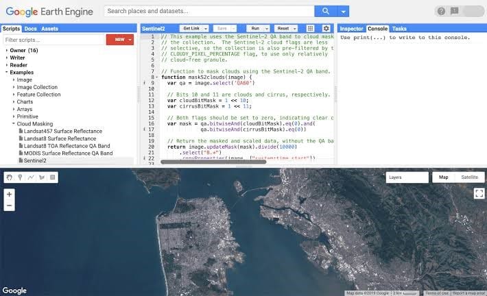
GEE is a cloud-based geospatial processing platform that provides access to petabytes of satellite imagery and other geospatial datasets. It offers a comprehensive set of tools and algorithms for analyzing, visualizing, and interpreting this data, enabling users to conduct large-scale remote sensing projects efficiently and effectively.
How GEE is Transforming Remote Sensing Data Analysis
GEE has revolutionized remote sensing data analysis in several ways:
- Scalability: GEE’s cloud-based architecture allows for the processing of massive datasets, enabling users to analyze large areas and time series data with ease. This scalability allows users to run complex analyses on large datasets without the need for extensive local computing resources.
- Accessibility: GEE provides a user-friendly interface and a vast library of pre-built algorithms, making it accessible to users with varying levels of technical expertise. With GEE, you have access to a vast archive of satellite imagery and remote sensing datasets. This includes historical data, current observations, and future projections, all available through a single platform. This comprehensive data access supports robust longitudinal studies and trend analysis.
- Advanced Analytical Tools: Google Earth Engine provides a suite of advanced tools and algorithms for image processing, feature extraction, and spatial analysis. Users can apply machine learning techniques, perform change detection, and generate sophisticated geospatial models with ease.
- Real-Time Insights: The platform enables near-real-time data processing, allowing for timely insights into environmental changes, disaster response, and other critical applications. This immediacy enhances the ability to make informed decisions based on the latest available information.
- Efficiency: GEE’s parallel processing capabilities significantly accelerate data processing, enabling users to obtain results faster and more efficiently.
- Integration: GEE seamlessly integrates with other geospatial tools and platforms, facilitating data sharing and collaboration.
- Cost-Effectiveness: GEE offers a free tier for individual users and affordable pricing for commercial applications, making it a cost-effective solution for remote sensing projects.
Why Geoinfotech Resources Limited is the Right Partner for Your Remote Sensing Projects
At GeoInfotech Group, we recognize the transformative potential of Google Earth Engine and are committed to helping you harness it to its fullest extent. We are a leading remote sensing and geospatial data analysis company with a proven track record of success. Our team of experts possesses extensive experience in utilizing GEE for a wide range of applications including:
Land cover and land use mapping
Forest monitoring and deforestation analysis
Agricultural productivity assessment
Disaster response and risk assessment
Environmental monitoring and impact assessment
Here’s why we are the right partner for your remote sensing analysis:
- Expertise and Experience: Our team comprises seasoned professionals with extensive experience in remote sensing and geospatial analysis. We have a deep understanding of Google Earth Engine’s capabilities and how to leverage them to address complex challenges.
- Tailored Solutions: We offer customized solutions that align with your specific needs and objectives. Whether you’re looking to monitor environmental changes, assess land use, or conduct spatial analysis, we tailor our approach to deliver precise and actionable insights.
- End-to-End Support: From initial consultation to final analysis, GeoInfotech Resources limited provides comprehensive support throughout the project lifecycle. Our services include data acquisition, processing, analysis, and visualization, ensuring a seamless experience from start to finish.
- Commitment to Quality: Our commitment to quality and client satisfaction drives everything we do. We work closely with you to understand your objectives and deliver high-quality results that meet your expectations and exceed industry standards.
At Geoinfotech Resource Limited, our commitment to excellence, coupled with our expertise in GEE, ensures that we deliver high-quality and actionable insights to our clients.


