Document

REMOTE SENSING ELEMENTS EXPOSITORY

John Abodunwa

June 25, 2026

REMOTE SENSING ELEMENTS EXPOSITORY    

Elements of Remote Sensing

Remote Sensing Elements Expository involves various processes, procedures or steps in remote sensing. This, specifically, covers all the stages in remote sensing operation from the initial to the final stage.

Furthermore, it operates as a systematic sequence of energy generation, interaction, detection, transmission, and interpretation. Each stage is interdependent, and errors or distortions at any stage can affect the quality of the final data. These elements includes Emission of electromagnetic radiation, transmission through the atmosphere, interaction with the object, transmission of energy to the sensor, recording of energy by the sensor, and transmission of data to ground station and data processing.

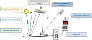
Figure 1a: Remote Sensing Elements and Mode of Operation/Technique


Remote Sensing Elements Expository: Emission of Electromagnetic Radiation (Energy Source)

This is the initial stage of the remote sensing process where energy is generated and directed toward the Earth’s surface. Electromagnetic radiation is the energy reflected, absorbed and emitted by an object and this is emitted in waves that are able to transmit energy from one place to another.

For instance, trees, air, soil, water, computer, building, the Sun, the Earth, all the stars and planets are reflecting and emitting a wide range of electromagnetic waves, these waves originate from billions of vibrating electrons, atoms, and molecules, which emits and absorbs electromagnetic radiation in unique combination of wavelengths. Any object with a temperature above absolute zero (-273°C) continuously reflects, absorbs, and emits energy in a unique manner. This energy is called electromagnetic radiation.

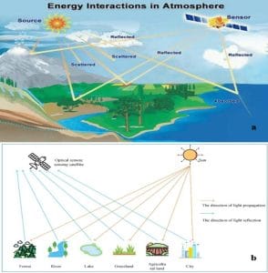
Figure 2: (a) Energy Interactions in Atmosphere         (b): Light Propagation and Reflection


Sources of Electromagnetic Radiation (EMR)

Based on the source of energy or light, remote sensing (RS) is classified into two as active and passive RS. Electromagnetic radiation travels in the form of waves characterized by wavelength and frequency, which determines how energy interacts with objects.


  • Active Sensor

Active sensors generate their own energy. They have their source of light or illumination (energy) and their sensors measure reflected energy. In the case of active Remote Sensing, energy is generated and sent from the RS platform towards the targets.

Sensors onboard the remote sensing platform record the energy reflected from the targets while most of the microwave RS is done through Active RS. Examples include RADAR (Radio Detection and Ranging) and LiDAR (Light Detection and Ranging). These systems can operate day and night and are less affected by cloud cover (especially radar).


  • Passive Sensor

Passive sensors uses natural energy which is the sun. The sun is the primary source of energy for the passive sensor and it emits radiation across a wide spectrum (visible, infrared, ultraviolet). Most Earth observation satellites (e.g., optical sensors) rely on solar illumination and most of the RS systems work in passive mode, using solar energy as the source of EMR. They measures reflected sunlight that is emitted from the sun.  Airborne and spaceborne sensors record solar energy reflected from targets within specific wavelength bands.

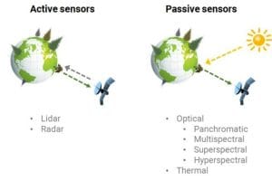
Figure 3: Active and Passive Sensor


Remote Sensing Elements Expository: Transmission through the Atmosphere to the Object on the Ground

As EMR travels from the source to the Earth’s surface, atmospheric constituents modify the signal. There are three major atmospheric effects which are scattering, absorption and atmospheric windows.

Scattering: This occurs when particles or gases redirect EMR. Scattering is of three types (Figure 4),
Namely;

  • Rayleigh scattering (by small particles like air molecules; affects shorter wavelengths such as blue light),
  • Mie scattering (by dust, smoke, water vapor) and
  • non-selective scattering (by large particles like clouds; affects all wavelengths).

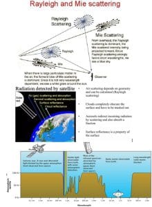
Figure 4: shows the process of transmission through the atmosphere in remote sensing including the major atmospheric effects (scattering, absorption and atmospheric windows) and wavelength.


Absorption: Certain gases absorb specific wavelengths and these are Ozone absorbs, ultraviolet radiation, Water vapor absorbs infrared radiation and carbon dioxide absorbs thermal radiation

Atmospheric Windows: This include the

  • Regions where EMR passes through with minimal absorption and
  • Sensors are designed to operate within these windows.


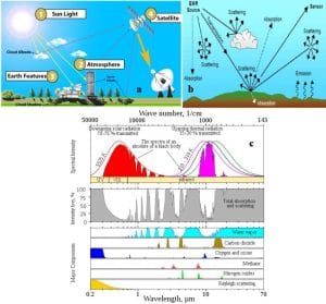
Figure 5: Remote Sensing Transmission Processes through the Atmosphere


Implication of transmission through the Atmosphere: Atmospheric interference can distort signals, so corrections (atmospheric correction) are often applied during data processing.


Interaction with the Object

When EMR reaches the Earth’s surface, it interacts with objects in three primary ways:

  1. Reflection: In this process, the surface reflects incoming energy back toward the sensor, the proportion reflected is called reflectance and reflection varies by material. For instance, vegetation reflects strongly in near-infrared, water absorbs most radiation and soil has moderate reflectance
  2. Absorption: Energy is absorbed and converted into heat. It also influences temperature and thermal emission.
  3. Transmission: Energy passes through the material (e.g., clear water, glass) and this depends on the spectral signature or characteristics of the object.


Spectral Signature

A spectral signature is a unique characteristic of an object that analysts use for identification. Each object has a unique pattern of reflection across wavelengths known as a spectral signature, which enables identification.

For example, Healthy vegetation: high near-infrared reflectance, Dry soil: higher reflectance in visible wavelengths, Water: low reflectance across most bands.


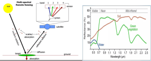
Figure 6: Interaction with the Object


Transmission of Energy to the Sensor

After interacting with the surface, reflected or emitted energy travels back through the atmosphere to the sensor.

The following considerations are required:

  • Signals may again be scattered or absorbed,
  • Distance between object and sensor affects signal strength.
  • In addition, Angle of observation (sensor geometry) influences data quality.

The types of energy detected are reflected solar radiation (visible and near-infrared) and emitted thermal radiation (thermal infrared).


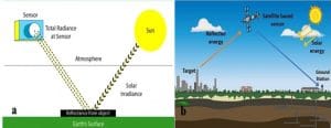
Figure 7: (a) Total Radiance at Senor and Solar irradiance, (b) Reflected Energy from Targeted Object in Remote Sensing


Recording of Energy by the Sensor

Sensors detect incoming radiation and convert it into measurable signals. The two types of sensors are photographic sensors (older systems) and electronic sensors (modern systems using CCD or CMOS detectors).

Three processes are involved in recording of energy by the sensor include Sensor elements (pixels) detect incoming energy, convert it into electrical signals, and quantify it as Digital Numbers (DNs). Resolution Factors are  Spatial resolution: pixel size, Spectral resolution: number of bands, and  Radiometric resolution: sensitivity to energy differences.

Figure 6b shows an electronic sensor measures intensity of the terrain and samples the analog electrical signal in an image then converts it to a digital number (DN).

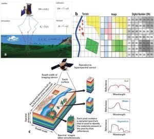
Figure 8: Recording of Energy by the Sensor


Transmission of Data to Ground Station

Satellite or airborne platform transmits the recorded data to Earth, the methods involve are direct downlink to ground receiving stations and relay satellites (e.g., communication satellites). At the ground stations facilities are equipped with antennas and receivers to collect raw data.

For example, earth observation satellites transmit data to global receiving networks for processing.


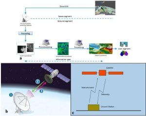
Figure 9: Transmission of Data to Ground Station


Data Processing

Analysts process raw data into usable formats before interpretation and the processing steps are (1) Radiometric Correction, (2) Removes sensor and atmospheric distortions, (3) Geometric Correction (Aligns image with geographic coordinates), (4) Image Enhancement (Improves contrast and visibility9, (5) Image Classification (Assigns pixels to categories (e.g., forest, water, urban)) and (6) False Color Composites (Combines bands to highlight features). Also, The outputs include digital images, maps and thematic datasets.


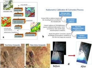
Figure 10: Data Processing Stages

Data Analysis and Interpretation

Data analysis and interpretation is the final and most critical stage, which involves the extraction of information for decision-making. Methods of analysis are Visual Interpretation: Based on tone, texture, shape, pattern, and color, Digital Analysis: Computer-based classification and algorithms, GIS Integration: Combining remote sensing data with other spatial datasets and Change Detection: Comparing images over time.

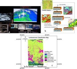
Figure 11: Data Analysis and Interpretation

Conclusion

Finally, the Remote Sensing Elements Expository process is a multi-stage system involving energy emission, atmospheric interaction, surface response, detection, transmission, processing, and interpretation. Each stage contributes to the accuracy and reliability of the final data product. A thorough understanding of these elements is essential for effective application in environmental monitoring, resource management, disaster response, and scientific research.

RECENT ACTIVITIES AND PROJECT...

Spatial Modelling of Agricultural Suitability Using Multi-Criteria Evaluation and GeoAI-Inspired Geospatial Analysis       by Sterling Umoren; Maps produced by Ewenla Abimbola

Spatial Modelling of Agricultural Suitability Using Multi-Criteria Evaluation and GeoAI-Inspired Geospatial Analysis by Sterling Umoren; Maps produced by Ewenla Abimbola

Geospatial Analysis of Health and Educational Facilities in Sardauna, Taraba State by Adedolapo

Geospatial Analysis of Health and Educational Facilities in Sardauna, Taraba State by Adedolapo

POTENTIAL IMPACT OF A CLOSURE OF THE STRAIT OF HORMUZ ON GLOBAL OIL SUPPLY AND ITS IMPLICATIONS FOR THE NIGERIAN OIL ECONOMY BY EDET JOHN

POTENTIAL IMPACT OF A CLOSURE OF THE STRAIT OF HORMUZ ON GLOBAL OIL SUPPLY AND ITS IMPLICATIONS FOR THE NIGERIAN OIL ECONOMY BY EDET JOHN

GEOSPATIAL ASSESSMENT OF OPTIMAL SOLAR ENERGY SITE SUITABILITY ACROSS OBIO/AKPOR LOCAL GOVERNMENT AREA, PORT HARCOURT USING SATELLITE DATA by Aderonke Lande

GEOSPATIAL ASSESSMENT OF OPTIMAL SOLAR ENERGY SITE SUITABILITY ACROSS OBIO/AKPOR LOCAL GOVERNMENT AREA, PORT HARCOURT USING SATELLITE DATA by Aderonke Lande

DRONE TOPOGRAPHIC SURVEY: HOW GEOINFOTECH SUPPORTED LAND DEVELOPMENT PLANNING IN IGABI, KADUNA STATE

DRONE TOPOGRAPHIC SURVEY: HOW GEOINFOTECH SUPPORTED LAND DEVELOPMENT PLANNING IN IGABI, KADUNA STATE

PRECISION TOPOGRAPHIC SURVEY AND MAPPING: HOW GEOINFOTECH SUPPORTED MINING SITE PLANNING IN JOS THROUGH DRONE TECHNOLOGY

PRECISION TOPOGRAPHIC SURVEY AND MAPPING: HOW GEOINFOTECH SUPPORTED MINING SITE PLANNING IN JOS THROUGH DRONE TECHNOLOGY

ROUTE TOPO SURVEY AND MAPPING: HOW GEOINFOTECH SUPPORTED THE ENUGU CABLE CAR PROJECT THROUGH ADVANCED GEOSPATIAL SOLUTIONS

ROUTE TOPO SURVEY AND MAPPING: HOW GEOINFOTECH SUPPORTED THE ENUGU CABLE CAR PROJECT THROUGH ADVANCED GEOSPATIAL SOLUTIONS

BOUNDARY SURVEY AND ENCROACHMENT ANALYSIS: HOW EGBIN POWER PLANT IMPROVED LAND MANAGEMENT THROUGH GEOSPATIAL TECHNOLOGY

BOUNDARY SURVEY AND ENCROACHMENT ANALYSIS: HOW EGBIN POWER PLANT IMPROVED LAND MANAGEMENT THROUGH GEOSPATIAL TECHNOLOGY

DRONE APPLICATION IN AERIAL SURVEY AND MAPPING: HOW GEOINFOTECH ENHANCED AGRICULTURAL SITE PLANNING IN OSEFA THROUGH GEOSPATIAL TECHNOLOGY

DRONE APPLICATION IN AERIAL SURVEY AND MAPPING: HOW GEOINFOTECH ENHANCED AGRICULTURAL SITE PLANNING IN OSEFA THROUGH GEOSPATIAL TECHNOLOGY

AERIAL SURVEY AND MAPPING FOR AGRICULTURAL SITE PLANNING: HOW GEOINFOTECH IMPROVED AGRICULTURAL DEVELOPMENT IN ILORA THROUGH DRONE TECHNOLOGY

AERIAL SURVEY AND MAPPING FOR AGRICULTURAL SITE PLANNING: HOW GEOINFOTECH IMPROVED AGRICULTURAL DEVELOPMENT IN ILORA THROUGH DRONE TECHNOLOGY

URABN HEAT ISLAND EFFECT IN CALABAR MUNICIPAL

URABN HEAT ISLAND EFFECT IN CALABAR MUNICIPAL

ANALYZING URBANIZATION TRENDS IN KANO STATE, NIGERIA USING NIGHTTIME LIGHTS REMOTE SENSING DATA

ANALYZING URBANIZATION TRENDS IN KANO STATE, NIGERIA USING NIGHTTIME LIGHTS REMOTE SENSING DATA

COMPREHENSIVE OFFSHORE SURVEILLANCE AND MARITIME INFRASTRUCTURE MONITORING

COMPREHENSIVE OFFSHORE SURVEILLANCE AND MARITIME INFRASTRUCTURE MONITORING

Comprehensive Aerial Survey and Mapping for Golf Course Asset Management at Lakowe Golf Lake

Comprehensive Aerial Survey and Mapping for Golf Course Asset Management at Lakowe Golf Lake

Professional Drone Training Program for Enhanced Corporate Security Operations at Sahara Group

Professional Drone Training Program for Enhanced Corporate Security Operations at Sahara Group

Advanced Aerial Topographic Survey and Mapping for Land Development in Ogun State

Advanced Aerial Topographic Survey and Mapping for Land Development in Ogun State

Precision RGB and Thermal Imaging Revolutionizes Solar Infrastructure Inspection In Enugu

Precision RGB and Thermal Imaging Revolutionizes Solar Infrastructure Inspection In Enugu

Advanced Drone-Based Topographic Survey for Precision Land Development Planning

Advanced Drone-Based Topographic Survey for Precision Land Development Planning

Mapping the Future: Comprehensive Area Survey Transforms Land Development in Akure

Mapping the Future: Comprehensive Area Survey Transforms Land Development in Akure

Precision Topographical Survey and Mapping for Smarter Infrastructure Planning

Precision Topographical Survey and Mapping for Smarter Infrastructure Planning

Precision Drone Volumetric Surveys: How Purechem Industries Optimized Mineral Stockpile Management

Precision Drone Volumetric Surveys: How Purechem Industries Optimized Mineral Stockpile Management

Advanced Mapping & Environmental Survey for Ilubirin Property, Lagos Island

Advanced Mapping & Environmental Survey for Ilubirin Property, Lagos Island

Unveiling the Invisible: LiDAR Technology Transforms Terrain Analysis in Abeokuta North

Unveiling the Invisible: LiDAR Technology Transforms Terrain Analysis in Abeokuta North

 DETAILED AERIAL, LAND SURVEY AND GIS ANALYSIS FOR ADVANCED REAL ESTATE DEVELOPMENT

 DETAILED AERIAL, LAND SURVEY AND GIS ANALYSIS FOR ADVANCED REAL ESTATE DEVELOPMENT

Professional Drone Mapping and GIS Training For ETA-ZUMA Mining Company

Professional Drone Mapping and GIS Training For ETA-ZUMA Mining Company

Installation of Intelligent Traffic Lights

Installation of Intelligent Traffic Lights

Geological Report on a Mining/Exploration Survey

Geological Report on a Mining/Exploration Survey

Drone Survey and Mapping of Shaishen Foods Limited

Drone Survey and Mapping of Shaishen Foods Limited

Lidar Topographic Mapping Project

Lidar Topographic Mapping Project

Geophysical/hydrogeophysical Studies for Groundwater Development

Geophysical/hydrogeophysical Studies for Groundwater Development

Togo Digital Terrain Model Project

Togo Digital Terrain Model Project

Drone Mapping of Parts of Lome Rail Line for Graceland Energy Located at Lome Togo

Drone Mapping of Parts of Lome Rail Line for Graceland Energy Located at Lome Togo

Drone/land Survey of Pure-chem Industrial Limited, Ogun State.

Drone/land Survey of Pure-chem Industrial Limited, Ogun State.

Drone Inspection/survey of Southern Lake Estate, Chevron, Lekki, Lagos State

Drone Inspection/survey of Southern Lake Estate, Chevron, Lekki, Lagos State

Anniversary-Workshop on the Application of Remote Sensing and Drone Technology in GIS -Abuja

Anniversary-Workshop on the Application of Remote Sensing and Drone Technology in GIS -Abuja

Topographic Mapping of Oyo State

Topographic Mapping of Oyo State

Topographic Mapping of Part of the Local Government Areas in Oyo State

Topographic Mapping of Part of the Local Government Areas in Oyo State

Topographic Mapping of Part of Kwara, Ekiti and Kogi State Local Government Area

Topographic Mapping of Part of Kwara, Ekiti and Kogi State Local Government Area

Political Map of South West, Nigeria Located in Nigeria

Political Map of South West, Nigeria Located in Nigeria

Topographic Mapping of Parts of Niger State Located at Niger State, Nigeria

Topographic Mapping of Parts of Niger State Located at Niger State, Nigeria

Topographic Mapping of Part of Kwara, Ekiti, and Kogi State Local Government Area Located in Nigeria

Topographic Mapping of Part of Kwara, Ekiti, and Kogi State Local Government Area Located in Nigeria

Topographic Mapping of Part of Kwara State Local Government Area Located at Kwara State Nigeria

Topographic Mapping of Part of Kwara State Local Government Area Located at Kwara State Nigeria

Flood Analysis of Amuwo-odofin Orthophoto.

Flood Analysis of Amuwo-odofin Orthophoto.

Site Inspection Using Drone of Water Corporation Located at Oke-aro Agege

Site Inspection Using Drone of Water Corporation Located at Oke-aro Agege

24,000 meter Lome Rail Line for Drone Mapping, Graceland Energy Located at Lome, Togo

24,000 meter Lome Rail Line for Drone Mapping, Graceland Energy Located at Lome, Togo

10 Drone Inspection Traffic Signal in Lagos

10 Drone Inspection Traffic Signal in Lagos

Lagos October 1st Free GIS Training Workshop

Lagos October 1st Free GIS Training Workshop

Osun state parcel project

Osun state parcel project

Drone Mapping & Vectorization Of Abu-allied Farm

Drone Mapping & Vectorization Of Abu-allied Farm

Proposal for aerial deployment, tracking and monitoring of threats in victoria island phase 1 and ikoyi phase 2, nigeria

Proposal for aerial deployment, tracking and monitoring of threats in victoria island phase 1 and ikoyi phase 2, nigeria

Jabi Lake Mall Solar Inspection – Abuja

Jabi Lake Mall Solar Inspection – Abuja

Ground Control and Drone Survey for Mast 3D Modeling

Ground Control and Drone Survey for Mast 3D Modeling

Telecom Drone 3D and 2D Modeling of Cellsite

Telecom Drone 3D and 2D Modeling of Cellsite

Free GIS Spatial Analysis Training (Lagos Branch)

Free GIS Spatial Analysis Training (Lagos Branch)

800 Building Plots Aerial Capture and Delineation for Database. Greenfield Estate

800 Building Plots Aerial Capture and Delineation for Database. Greenfield Estate

100 Hectares Aerial Survey with Differential GPS of High Accuracy

100 Hectares Aerial Survey with Differential GPS of High Accuracy

Protected: Nigeria Crime Report and Dashboard

Protected: Nigeria Crime Report and Dashboard

Drone Survey and Mapping – Victoria Island  Copy

Drone Survey and Mapping – Victoria Island Copy

Akwa-Ibom 500 Hectares Drone Survey and Mapping in Nigeria

Akwa-Ibom 500 Hectares Drone Survey and Mapping in Nigeria

Ground Control Establishment – Republic of the Niger – Kano, Kastina, Jigawa, Kaduna

Ground Control Establishment – Republic of the Niger – Kano, Kastina, Jigawa, Kaduna

Drone Survey and Mapping – Victoria Island

Drone Survey and Mapping – Victoria Island

Control Point Establishment – DGPS

Control Point Establishment – DGPS

Land Survey – Northern Nigeria

Land Survey – Northern Nigeria

Biodiversity Mapping – Sweden

Biodiversity Mapping – Sweden

Flood Impact Mapping – United Kingdom

Flood Impact Mapping – United Kingdom

M and E GIS Dashboard for Control Establishment Project

M and E GIS Dashboard for Control Establishment Project

Geodatabase Management System Training For National Boundary Commission

Geodatabase Management System Training For National Boundary Commission

Nigeria Topographic Map – Project

Nigeria Topographic Map – Project

Abuja Training on Introduction to GIS

Abuja Training on Introduction to GIS

200 Hectares Land and Drone Survey – Lagos Nigeria

200 Hectares Land and Drone Survey – Lagos Nigeria

Inspection of 30 hectares drainage

Inspection of 30 hectares drainage

Drainage Drone Mapping and Surveying in Lagos Nigeria

Drainage Drone Mapping and Surveying in Lagos Nigeria

GIS Cadastral Mobile Application

GIS Cadastral Mobile Application

Abuja Topographical Map – HD GIS Mapping

Abuja Topographical Map – HD GIS Mapping

Ground Topography Survey (Lagos Island)

Ground Topography Survey (Lagos Island)

2.7km2 Topography Survey in Snake Island

2.7km2 Topography Survey in Snake Island

GIS Masterclass

GIS Masterclass

Sokoto Contour Map

Sokoto Contour Map

NDVI Vegetation Assessment in Lagos State

NDVI Vegetation Assessment in Lagos State

Lagos drone training master class

Lagos drone training master class

Ifako drone topographic survey and mapping

Ifako drone topographic survey and mapping

CMD Lagos 3D mapping aerial modeling

CMD Lagos 3D mapping aerial modeling

GIS and Drone Masterclass

GIS and Drone Masterclass

Drone aerial survey and mapping – Lagos Island _ Somolu

Drone aerial survey and mapping – Lagos Island _ Somolu

Covid-19 | Nigeria Data Visualisation

Covid-19 | Nigeria Data Visualisation

Benue Flood Analysis

Benue Flood Analysis

Aerial photography Ile-Ife Osun State

Aerial photography Ile-Ife Osun State

Kenya Forest Project

Kenya Forest Project

Tunsun Consultants Ltd

Tunsun Consultants Ltd

Introduction To Gis In Maritime at the National Boundary Commission

Introduction To Gis In Maritime at the National Boundary Commission

Training on GIS and Drone Mapping (batch-4 & 5)

Training on GIS and Drone Mapping (batch-4 & 5)

Osun Flood Mapping

Osun Flood Mapping

Lahass International Limited

Lahass International Limited

Linguistic Association of Nigeria

Linguistic Association of Nigeria

West African Indexing Services

West African Indexing Services

Lagos Ikeja Road Network Map

Lagos Ikeja Road Network Map

LASU Land Regularisation Portal

LASU Land Regularisation Portal

Lingua Plus International

Lingua Plus International

Lagferry Web Route

Lagferry Web Route

YOU MAY ALSO LIKE...

COURSES

Explore Geoinfotech courses and establish a strong foundation of knowledge and skills to be productive with the latest Technology.

Can Geospatial Technology Solve Nigeria’s Insecurity Problem Part 2

Nigeria continues to face a range of security concerns, including banditry, kidnapping, illegal mining, border incursions, and communal conflicts. As…

Find out more

Weekend Class Training

The flexible weekend class allows working professionals and students to upskill efficiently while gaining immediately applicable knowledge for careers in…

Find out more

Differential GPS (DGPS) Land Surveying Training

Professional 2 weekends ▪ Field Experience 5.0 (100% Practical) ▪ Exam & CertificateFree Software and AppsHands on Practical and Field…

Find out more

Training on AutoCAD for Surveying and Mapping

Duration: 4 Weekends (Every Friday 2pm and Saturday 10am)
Package: Field Experience, 100% Hands-on practical, jotter, Biro and Software Others, Test, Exam and Certificate.

Find out more
Training Venue Available in,Lagos and Abuja100253Nigeria
+ Google Map