GPX to Shape file using QGIS
Download Sample File
GPX to Shape file using QGIS

RECENT ACTIVITIES AND PROJECT...
YOU MAY ALSO LIKE...

REMOTE SENSING ELEMENTS EXPOSITORY Elements of Remote Sensing Remote Sensing Elements...

IMPORTANCE OF REMOTELY SENSED SATELLITE DATA AND IMAGES Introduction Remotely sensed...

Top Remote Sensing Training Centres in Lagos, Abuja, and Port Harcourt. How to Find the Right...

Georeferencing Satellite Imagery Georeferencing is one of the most important processes in GIS...
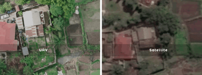
Drone Mapping vs Satellite Imagery: Which is Better? In the world of GIS, remote sensing,...

Drone Survey Services in Akwa Ibom State At Geoinfotech, we provide professional drone survey...
COURSES
Explore Geoinfotech courses and establish a strong foundation of knowledge and skills to be productive with the latest Technology.
Nigeria continues to face a range of security concerns, including banditry, kidnapping, illegal mining, border incursions, and communal conflicts. As…
The flexible weekend class allows working professionals and students to upskill efficiently while gaining immediately applicable knowledge for careers in…
Professional 2 weekends ▪ Field Experience 5.0 (100% Practical) ▪ Exam & CertificateFree Software and AppsHands on Practical and Field…
Duration: 4 Weekends (Every Friday 2pm and Saturday 10am)
Package: Field Experience, 100% Hands-on practical, jotter, Biro and Software Others, Test, Exam and Certificate.


