

Applications of Hyperspectral Remote Sensing in Mineral Exploration
Applications of Hyperspectral Remote Sensing in Mineral Exploration are transforming how geologists identify and evaluate areas with mineral potential. By capturing detailed information across hundreds of narrow spectral bands, hyperspectral remote sensing helps identify minerals, map geological materials, detect alteration zones, and improve exploration targeting.
How do geologists identify promising mineral deposits without spending months conducting extensive field surveys? Increasingly, they use hyperspectral remote sensing to analyze the Earth’s surface and identify spectral characteristics associated with different minerals. As a result, exploration teams can reduce unnecessary fieldwork, improve targeting, and make better decisions before excavation or drilling begins.
As Nigeria continues to develop its mining sector, applications of hyperspectral remote sensing in mineral exploration can provide valuable geospatial information for faster, more efficient, and more sustainable mineral exploration.
What Is Hyperspectral Remote Sensing?
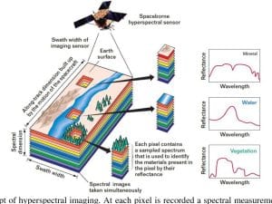
Hyperspectral remote sensing is an advanced imaging technology that captures information across hundreds of narrow spectral bands. Unlike conventional satellite imagery, which usually records a limited number of broad spectral bands, hyperspectral sensors capture subtle differences in how materials reflect and absorb electromagnetic energy.
Every mineral has a unique spectral signature, often described as its spectral fingerprint. These signatures result from the way minerals interact with electromagnetic radiation. By analyzing these patterns, geologists can identify and map minerals across large areas.
Therefore, hyperspectral imagery provides more detailed mineralogical information than many conventional remote sensing datasets.
How Does Hyperspectral Remote Sensing Work?
Hyperspectral sensors can operate from satellites, aircraft, drones, and other platforms. These sensors collect reflected electromagnetic energy from the Earth’s surface and organize the information into detailed spectral datasets.
The mineral exploration workflow generally involves the following steps:
- Capturing hyperspectral imagery across many spectral bands
- Preprocessing and correcting the imagery
- Removing atmospheric and other sources of noise
- Extracting relevant spectral information
- Comparing observed signatures with mineral spectral libraries
- Classifying and mapping minerals
- Integrating the results with geological and geospatial datasets
- Identifying areas with potential for further exploration
When professionals combine hyperspectral imagery with GIS, they can overlay geological, geochemical, geophysical, and topographic information. Consequently, exploration teams can develop more comprehensive models of mineral potential.
Applications of Hyperspectral Remote Sensing in Mineral Exploration
The applications of hyperspectral remote sensing in mineral exploration extend beyond simply identifying individual minerals. The technology can support geological interpretation, alteration mapping, exploration targeting, environmental assessment, and decision-making.
Mineral Identification and Deposit Detection
One of the most important applications involves identifying minerals from their characteristic spectral responses.
Hyperspectral data can help detect and map minerals and mineral groups associated with exploration targets, including:
- Iron-bearing minerals
- Clay minerals
- Carbonate minerals
- Sulphate minerals
- Hydroxyl-bearing minerals
- Silicate minerals
- Iron oxides and hydroxides
- Alteration minerals associated with ore deposits
For example, geologists can analyze the spectral characteristics of surface materials and compare them with established mineral libraries. This approach can help identify areas that deserve further investigation.
However, hyperspectral remote sensing does not replace geological fieldwork, drilling, or laboratory analysis. Instead, it helps exploration teams prioritize locations for those activities.
Geological Mapping Using Hyperspectral Remote Sensing
Geological mapping represents another important application of hyperspectral remote sensing.
Different rocks and geological materials can exhibit different spectral responses. Therefore, hyperspectral imagery can help geologists distinguish surface materials and improve geological interpretation.
Professionals can use hyperspectral data to map:
- Rock units
- Surface mineral composition
- Geological contacts
- Alteration zones
- Iron-rich surfaces
- Clay-rich areas
- Structural features
- Exposed geological formations
These maps can complement existing geological information and provide additional evidence when assessing an exploration area.
Mineral Alteration Mapping
Hydrothermal alteration often provides important clues about the geological processes that formed mineral deposits. Alteration can change the mineral composition of surrounding rocks and create distinctive spectral characteristics.
Hyperspectral remote sensing can help identify alteration minerals such as:
- Kaolinite
- Illite
- Chlorite
- Muscovite
- Hematite
- Goethite
- Alunite
By mapping these minerals, geologists can identify alteration zones that may indicate hydrothermal activity or potential mineralization.
Consequently, alteration mapping can help narrow large exploration areas into smaller and more promising targets.
Exploration Targeting
Hyperspectral remote sensing can also support exploration targeting.
Instead of treating an entire study area as equally prospective, exploration teams can combine hyperspectral results with other datasets to identify areas that require closer investigation.
For example, professionals can integrate:
- Hyperspectral mineral maps
- Geological maps
- Geochemical data
- Geophysical data
- Digital elevation models
- Structural data
- Fault and lineament information
- Existing mineral occurrence data
GIS can then help combine these datasets into mineral prospectivity models.
As a result, exploration teams can rank areas according to their potential and focus field investigations on the most promising locations.
Reducing Mineral Exploration Costs
Traditional mineral exploration can involve extensive field surveys, sampling, laboratory analysis, and drilling. These activities require significant time and financial investment.
Hyperspectral remote sensing can help reduce some of these costs by providing preliminary information before extensive field campaigns begin.
For example, exploration teams can use hyperspectral data to:
- Identify priority areas
- Reduce unnecessary field visits
- Target geological sampling
- Improve drilling locations
- Reduce exploration uncertainty
- Prioritize areas for detailed investigation
This does not eliminate the need for fieldwork. Instead, it allows exploration teams to use their resources more strategically.
Mapping Surface Mineralization
Some mineral deposits and associated alteration minerals occur close to or at the Earth’s surface. Hyperspectral imagery can help identify these surface expressions by detecting their characteristic spectral responses.
Geologists can use the resulting maps to investigate areas where surface mineralization may indicate deeper geological processes.
This application becomes particularly useful across large and difficult-to-access exploration areas where conventional surveys may require substantial resources.
Environmental Monitoring Around Mining Areas
Hyperspectral remote sensing also has applications beyond the initial discovery of mineral resources.
Mining operations can affect vegetation, soil, water, and surrounding landscapes. Hyperspectral imagery can help monitor some of these environmental changes because different materials exhibit different spectral responses.
Potential applications include:
- Vegetation stress detection
- Land degradation monitoring
- Mine waste characterization
- Surface disturbance assessment
- Water-quality assessment
- Reclamation monitoring
- Identification of exposed waste materials
Therefore, hyperspectral technology can support environmental management throughout the mining lifecycle.
Supporting Sustainable Mineral Exploration
Modern exploration increasingly requires companies to consider environmental impacts alongside economic objectives.
Hyperspectral remote sensing can support this goal by helping companies understand surface conditions before carrying out extensive exploration activities.
With better spatial information, companies can plan field operations more efficiently, reduce unnecessary disturbance, and identify environmentally sensitive areas that require additional consideration.
In this way, remote sensing can contribute to more responsible mineral exploration practices.
Why Hyperspectral Remote Sensing Matters for Nigeria
Nigeria has significant deposits of mineral resources, including gold, limestone, iron ore, tin, lead, zinc, coal, and bitumen. However, identifying and developing these resources requires reliable geological information and efficient exploration methods.
Applications of Hyperspectral Remote Sensing in Mineral Exploration can provide several advantages for Nigeria’s growing mining sector.
These advantages include:
- Faster identification of mineral targets
- Improved geological interpretation
- Better alteration mapping
- Reduced exploration uncertainty
- More efficient field surveys
- Improved exploration targeting
- Better environmental monitoring
- Stronger integration of geospatial datasets
As Nigeria continues to diversify its economy beyond oil and gas, modern geospatial technologies can help improve the efficiency of mineral exploration.
How GIS Enhances Hyperspectral Mineral Exploration
GIS makes hyperspectral analysis even more useful by allowing professionals to combine spectral information with other spatial datasets.
For example, geoscientists can overlay hyperspectral mineral maps with geological maps, faults, drainage networks, elevation data, geochemical results, and known mineral occurrences.
GIS can help professionals:
- Integrate hyperspectral and geological datasets
- Analyze mineral distribution
- Map alteration zones
- Identify spatial relationships between minerals and structures
- Develop mineral prospectivity models
- Rank exploration targets
- Produce detailed exploration maps
- Visualize complex geological information
This integration creates a more complete picture of an exploration area and supports better decision-making.
Hyperspectral Remote Sensing vs Conventional Remote Sensing
Conventional multispectral remote sensing typically uses a smaller number of broader spectral bands. Hyperspectral remote sensing, on the other hand, captures hundreds of narrow and contiguous spectral bands.
This difference gives hyperspectral systems greater capability for distinguishing materials with subtle spectral differences.
For mineral exploration, this can be particularly valuable because many minerals have absorption features that may not appear clearly in conventional multispectral imagery.
However, hyperspectral datasets also require more storage, processing power, specialized software, and technical expertise. Therefore, professionals should select the appropriate sensor and processing workflow based on the objectives of each exploration project.
Challenges of Hyperspectral Remote Sensing in Mineral Exploration
Despite its advantages, hyperspectral remote sensing has some limitations.
Large Data Volumes
Hyperspectral sensors capture hundreds of spectral bands. Consequently, the resulting datasets can be significantly larger than conventional imagery.
Atmospheric Effects
Atmospheric conditions can affect the spectral information recorded by a sensor. Therefore, proper preprocessing and atmospheric correction remain important.
Limited Surface Exposure
Dense vegetation, water, soil cover, and weathering can obscure geological materials. As a result, hyperspectral imagery may not always detect the minerals beneath the surface.
Technical Expertise
Interpreting hyperspectral data requires knowledge of remote sensing, spectroscopy, geology, and image processing.
Need for Field Validation
Remote sensing results require ground verification. Field observations, laboratory analysis, geochemical sampling, and other exploration methods can confirm whether a remotely detected target represents actual mineralization.
How Geoinfotech Supports Mineral Exploration
Geoinfotech applies remote sensing and GIS technologies to support mineral exploration and natural resource management.
Our services can include:
- Hyperspectral image analysis
- Geological mapping
- Mineral mapping
- Mineral prospectivity modelling
- Drone surveys
- GIS and spatial analysis
- Remote sensing data processing
- Interactive geospatial applications
By combining remote sensing, GIS, and other geospatial technologies, we help transform complex spatial datasets into practical information for exploration and resource-management decisions.
Frequently Asked Questions
What are the main applications of hyperspectral remote sensing in mineral exploration?
The main applications include mineral identification, mineral mapping, geological mapping, alteration detection, exploration targeting, surface mineralization mapping, and environmental monitoring.
Can hyperspectral remote sensing detect gold?
Hyperspectral remote sensing generally does not detect gold directly in the same way that it identifies spectrally active minerals. However, it can identify alteration minerals and geological characteristics associated with certain gold deposits. These indicators can help geologists identify areas for further investigation.
What minerals can hyperspectral remote sensing identify?
Hyperspectral systems can identify many minerals with distinctive spectral characteristics. These include clay minerals, iron oxides, carbonates, sulphates, and several alteration minerals.
Is hyperspectral remote sensing useful in Nigeria?
Yes. Nigeria’s diverse geology and mineral resources create opportunities for applying hyperspectral remote sensing to geological mapping, alteration detection, mineral exploration, and environmental monitoring.
Can GIS be used with hyperspectral remote sensing?
Yes. GIS can integrate hyperspectral results with geological, geochemical, geophysical, topographic, and other spatial datasets. This integration supports mineral prospectivity modelling and exploration targeting.
Final Takeaway
Applications of Hyperspectral Remote Sensing in Mineral Exploration are changing how exploration teams analyze geological environments and identify potential mineral targets. The technology provides detailed spectral information that can support mineral identification, geological mapping, alteration detection, exploration targeting, and environmental monitoring.
However, hyperspectral remote sensing works best as part of an integrated exploration workflow. When professionals combine hyperspectral imagery with GIS, geological information, geochemical data, geophysical surveys, and field validation, they can develop a more reliable understanding of mineral potential.
For Nigeria, these capabilities could become increasingly valuable as the country expands its mining sector and seeks more efficient approaches to mineral exploration. By adopting advanced remote sensing and GIS technologies, exploration teams can improve targeting, reduce unnecessary fieldwork, and make more informed decisions while supporting more sustainable resource development.















































































