Hydrography
Hydrography is the branch of applied sciences that deals with the measurement and description of the physical features of oceans, seas, coastal areas, lakes, and rivers. It also predicts occurring changes in the water bodies over time, for the primary purpose of navigational safety and supporting other marine activities including economic development, security and defense, scientific research, and environmental protection.
The goal of hydrography is to map underwater topography (water levels and relief). It deals with the entire information chain, from data gathering at sea to map-making.
Methods of Hydrographic survey
- Surveying origins.
- Leveling.
- Coastline survey.
- Bathymetric surveying.
- Data edition.
A significant purpose of hydrographic surveying is to obtain data necessary for preparing nautical charts, which show water depths, navigation channels, structures (such as piers), breakwaters, and so on, and which are used by mariners.
– Maritime boundary delimitation
– National marine spatial data infrastructures
– Maritime defense and security
– Tsunami flood and inundation modeling
– Coastal zone management
– Tourism
– Marine science

By mapping out water depth, the shape of the seafloor and coastline, the location of possible obstructions and physical features of water bodies, hydrography helps to keep our maritime transportation system moving safely and efficiently
The primary reason for hydrographic surveys is to determine the depth of a body of water. It is necessary, in every construction project for the parties involved to know how deep their building area is. Furthermore, water depth is a key point of knowledge for maritime navigation. The data collected is used to update nautical charts and develop hydrographic models. Such information is vital to navigating the ocean and our international waterways.
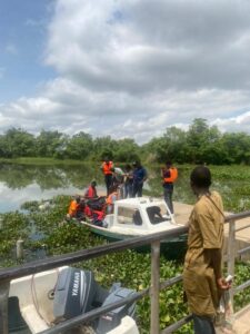
Currently, Geoinfotech students are taken on hydrographic surveys in the Mapping with GIS for the Maritime boundary course.
Registration is ongoing now.
Visit our training page to register and to know more.