Document

Drone Livestreaming in Nigeria


Drone Livestreaming in Nigeria

For years, commercial drone operations followed a predictable pattern. A pilot flew a mission, saved data to an SD card, and uploaded it hours later. While valuable, this delayed workflow creates a dangerous data gap during emergencies. When a critical asset fails or a security breach occurs, waiting for a post-flight report is not an option.

Major organizations are now achieving instant situational awareness. They do this by broadcasting a UAV live video feed straight to off-site stakeholders. Whether you need remote drone surveillance services in Nigeria across a pipeline corridor or a secure drone live streaming platform during a fast-moving emergency, this technology delivers low-latency clarity. Furthermore, for industries requiring rapid responses, livestreaming bridges the gap between field operations and executive decision-making.

What is Drone Livestreaming?

Drone livestreaming in Nigeria is the secure, real-time transmission of aerial video from a UAV directly to remote viewers. This includes both visual and thermal data. Instead of restricting the camera view to the pilot’s handheld controller, modern platforms broadcast an encrypted feed instantly. Therefore, command centers, field laptops, and mobile devices anywhere in the world can receive it.

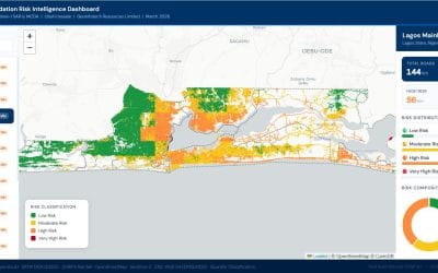
As one of the pioneering drone technology companies in Nigeria, Geoinfotech turns real-time aerial data into a hardened operational capability. Additionally, we are leading deployments across every region of the country. We provide secure tactical overwatch for the commercial corridors of drone livestreaming in Lagos, Port Harcourt, and across Nigeria.

Which Industries Need Drone Livestreaming?

1. Oil & Gas

When a sensor flags a pressure drop or potential leak, every minute counts. Instead of deploying ground crews to navigate hazardous terrain, operators launch a UAV equipped for drone livestreaming. This is especially true in the Niger Delta, where terrain is particularly challenging.

Deploying specialized pipeline monitoring drones in Port Harcourt allows energy organizations to inspect live thermal or optical feeds. Consequently, asset management teams no longer need to be physically on-site to make high-stakes calls. With a robust drone live streaming platform, they can verify anomalies and coordinate a precise response instantly.

2. Public Safety, Emergency Response, and Tactical Command

For first responders, real-time data saves lives. During structure fires, search-and-rescue missions, or critical facility incidents, a secure aerial feed provides an immediate overhead view. Moreover, this view reaches tactical command organizations in seconds.

By utilizing a high-performance drone live stream app, incident response teams can pinpoint structural hotspots. They can also track environmental hazards and guide ground personnel safely through rapidly changing environments. Furthermore, a remote drone live streaming setup means security organizations can monitor operations from a safe distance while staying fully informed.

3. Security

Industrial facilities, logistics hubs, and remote construction sites face continuous threats. These include vandalism, theft, and encroachment. Traditional static security cameras leave blind spots that intruders easily exploit.

Drones acting as dynamic, airborne security guards drastically upgrade facility defense. As a result, turnkey drone security surveillance in Lagos is already helping multinational organizations. Port operators are also using it to track intruders in real-time, monitor complex fence lines, and provide live video verification to law enforcement.

Why Drone Livestreaming in Nigeria is Critical for Corporate Asset Protection

1. Zero-Latency Decision Making for Nigerian Infrastructure

Eliminate the hours spent downloading, processing, and transferring aerial imagery. By integrating professional drone livestreaming in Nigeria, engineering and security organizations can make data-backed calls in seconds. Therefore, instant access to a Nigerian drone livestreaming feed transforms reactive security into proactive, real-time prevention.

2. Drastically Reduced Costs for Remote Asset Monitoring

Expert personnel no longer need to travel to hazardous or remote field sites. A single drone pilot operating a drone livestreaming service in Nigeria can broadcast live, high-definition footage to a global team of specialists. Consequently, this localized deployment slashes travel expenses, improves risk management, and eliminates costly operational downtime.

3. Enhanced Multi-Agency Collaboration and Command Control

Modern enterprise platforms include multi-viewer streaming links for cross-functional teams. These allow environmental compliance units, local security managers, and executive boards to view the same live footage simultaneously. As a result, secure drone livestreaming in Nigeria ensures flawless coordination and aligns all stakeholders instantly during critical events.

How to Set Up a Professional Drone Live Streaming Setup in Nigeria

Setting up a professional drone live streaming setup typically involves three core components.

The UAV Platform: High-end industrial drones equipped with dual optical and thermal cameras. These are capable of specialized EO/IR drone livestreaming.

The Transmission Layer: A cellular, satellite, or bonded network connection. This must sustain a stable HD video feed.

The Software Stack: A secure cloud-based software platform or dedicated drone livestreaming app. It receives, manages, and distributes the encrypted drone feed to authorized viewers across devices.

For operations in Nigeria, environmental factors such as variable cellular signal must be accounted for. However, Geoinfotech’s teams utilize advanced network bonding to overcome this challenge. This involves combining multiple network signals to ensure a reliable, high-definition stream even in low-connectivity environments.

Why Geoinfotech is Nigeria’s Leading Professional Drone Livestreaming Provider

Deploying advanced corporate drone infrastructure across West Africa requires deep local expertise. It also demands rigorous civil aviation compliance and a proven track record. Therefore, Geoinfotech stands out as the trusted engineering partner for local and multinational organizations.

1. Certified NCAA and ONSA Operational Clearance

Geoinfotech holds official clearance from the Nigerian Civil Aviation Authority (NCAA) and the Office of the National Security Adviser (ONSA). Additionally, our End-User Certificates and vetted flight access are already established. This means we provide immediate, hassle-free deployment for professional drone livestreaming and critical aerial operations nationwide.

2. Nationwide Operational Footprint for Commercial Drone Services

Whether your facilities require industrial pipeline monitoring drones in Port Harcourt or heavy asset drone security surveillance in Lagos, Geoinfotech rapidly deploys certified crews. Furthermore, our nationwide presence allows us to launch secure operations in any region. We provide low-latency aerial intelligence exactly where you need it most.

3. End-to-End Infrastructure for Professional Drone Livestreaming Solutions

From provisioning cutting-edge enterprise hardware to configuring your secure drone digital twin infrastructure, we handle it all. We seamlessly integrate encrypted cloud video feeds, supply highly trained drone pilots, and establish centralized control hubs. As a result, Geoinfotech manages the entire operational pipeline. This makes us the premier choice among drone technology companies in Nigeria for professional drone livestreaming setups.

Frequently Asked Questions (FAQs)

Q1: What are the primary benefits of drone livestreaming in Nigeria for corporate asset protection?

The major advantages include zero-latency decision-making, dramatically reduced operational costs, and enhanced stakeholder collaboration. Instead of waiting hours for post-flight data processing, corporate security and engineering teams get an immediate live drone video stream. Therefore, they can detect leaks, track security breaches, or monitor high-value facilities in real-time without risking ground personnel.

Q2: Is a special permit required for professional drone livestreaming in Nigeria?

Yes. Operating commercial drones and broadcasting live feeds legally requires strict authorization. Geoinfotech holds official operational clearance from the NCAA and the ONSA. Because we already have our End-User Certificates and vetted flight access in place, we can deploy immediately for your organization.

Q3: Can drone livestreaming apps transmit thermal and optical data simultaneously?

Yes. For high-stakes operations like industrial pipeline monitoring in Port Harcourt or facility defense, we deploy enterprise UAVs equipped with dual EO/IR sensors. Our secure drone livestreaming app broadcasts both crisp high-definition visual footage and precise thermal data to your remote command center. Consequently, you can catch hidden thermal anomalies or nighttime security threats instantly.

Q4: How do drone technology companies in Nigeria secure live feeds from hacking or interception?

Security is paramount for corporate and industrial operations. Therefore, Geoinfotech protects every Nigerian drone livestreaming broadcast with enterprise-grade AES-256 encryption. The transmission layer securely locks the feed from the aircraft to our cloud platform. This ensures that only authorized stakeholders with secure multi-viewer links can access the live aerial data.

Q5: Which cities can Geoinfotech deploy its drone livestreaming services?

Thanks to our nationwide footprint, Geoinfotech rapidly deploys certified crews anywhere in the country. We provide continuous tactical overwatch and drone security surveillance in Lagos, specialized pipeline monitoring drones in Port Harcourt, and remote infrastructure tracking across northern and southern corridors alike.


RECENT ACTIVITIES AND PROJECT...

DRONE TOPOGRAPHIC SURVEY: HOW GEOINFOTECH SUPPORTED LAND DEVELOPMENT PLANNING IN IGABI, KADUNA STATE

DRONE TOPOGRAPHIC SURVEY: HOW GEOINFOTECH SUPPORTED LAND DEVELOPMENT PLANNING IN IGABI, KADUNA STATE

PRECISION TOPOGRAPHIC SURVEY AND MAPPING: HOW GEOINFOTECH SUPPORTED MINING SITE PLANNING IN JOS THROUGH DRONE TECHNOLOGY

PRECISION TOPOGRAPHIC SURVEY AND MAPPING: HOW GEOINFOTECH SUPPORTED MINING SITE PLANNING IN JOS THROUGH DRONE TECHNOLOGY

ROUTE TOPO SURVEY AND MAPPING: HOW GEOINFOTECH SUPPORTED THE ENUGU CABLE CAR PROJECT THROUGH ADVANCED GEOSPATIAL SOLUTIONS

ROUTE TOPO SURVEY AND MAPPING: HOW GEOINFOTECH SUPPORTED THE ENUGU CABLE CAR PROJECT THROUGH ADVANCED GEOSPATIAL SOLUTIONS

BOUNDARY SURVEY AND ENCROACHMENT ANALYSIS: HOW EGBIN POWER PLANT IMPROVED LAND MANAGEMENT THROUGH GEOSPATIAL TECHNOLOGY

BOUNDARY SURVEY AND ENCROACHMENT ANALYSIS: HOW EGBIN POWER PLANT IMPROVED LAND MANAGEMENT THROUGH GEOSPATIAL TECHNOLOGY

DRONE APPLICATION IN AERIAL SURVEY AND MAPPING: HOW GEOINFOTECH ENHANCED AGRICULTURAL SITE PLANNING IN OSEFA THROUGH GEOSPATIAL TECHNOLOGY

DRONE APPLICATION IN AERIAL SURVEY AND MAPPING: HOW GEOINFOTECH ENHANCED AGRICULTURAL SITE PLANNING IN OSEFA THROUGH GEOSPATIAL TECHNOLOGY

AERIAL SURVEY AND MAPPING FOR AGRICULTURAL SITE PLANNING: HOW GEOINFOTECH IMPROVED AGRICULTURAL DEVELOPMENT IN ILORA THROUGH DRONE TECHNOLOGY

AERIAL SURVEY AND MAPPING FOR AGRICULTURAL SITE PLANNING: HOW GEOINFOTECH IMPROVED AGRICULTURAL DEVELOPMENT IN ILORA THROUGH DRONE TECHNOLOGY

URABN HEAT ISLAND EFFECT IN CALABAR MUNICIPAL

URABN HEAT ISLAND EFFECT IN CALABAR MUNICIPAL

ANALYZING URBANIZATION TRENDS IN KANO STATE, NIGERIA USING NIGHTTIME LIGHTS REMOTE SENSING DATA

ANALYZING URBANIZATION TRENDS IN KANO STATE, NIGERIA USING NIGHTTIME LIGHTS REMOTE SENSING DATA

COMPREHENSIVE OFFSHORE SURVEILLANCE AND MARITIME INFRASTRUCTURE MONITORING

COMPREHENSIVE OFFSHORE SURVEILLANCE AND MARITIME INFRASTRUCTURE MONITORING

Comprehensive Aerial Survey and Mapping for Golf Course Asset Management at Lakowe Golf Lake

Comprehensive Aerial Survey and Mapping for Golf Course Asset Management at Lakowe Golf Lake

Professional Drone Training Program for Enhanced Corporate Security Operations at Sahara Group

Professional Drone Training Program for Enhanced Corporate Security Operations at Sahara Group

Advanced Aerial Topographic Survey and Mapping for Land Development in Ogun State

Advanced Aerial Topographic Survey and Mapping for Land Development in Ogun State

Precision RGB and Thermal Imaging Revolutionizes Solar Infrastructure Inspection In Enugu

Precision RGB and Thermal Imaging Revolutionizes Solar Infrastructure Inspection In Enugu

Advanced Drone-Based Topographic Survey for Precision Land Development Planning

Advanced Drone-Based Topographic Survey for Precision Land Development Planning

Mapping the Future: Comprehensive Area Survey Transforms Land Development in Akure

Mapping the Future: Comprehensive Area Survey Transforms Land Development in Akure

Precision Topographical Survey and Mapping for Smarter Infrastructure Planning

Precision Topographical Survey and Mapping for Smarter Infrastructure Planning

Precision Drone Volumetric Surveys: How Purechem Industries Optimized Mineral Stockpile Management

Precision Drone Volumetric Surveys: How Purechem Industries Optimized Mineral Stockpile Management

Advanced Mapping & Environmental Survey for Ilubirin Property, Lagos Island

Advanced Mapping & Environmental Survey for Ilubirin Property, Lagos Island

Unveiling the Invisible: LiDAR Technology Transforms Terrain Analysis in Abeokuta North

Unveiling the Invisible: LiDAR Technology Transforms Terrain Analysis in Abeokuta North

 DETAILED AERIAL, LAND SURVEY AND GIS ANALYSIS FOR ADVANCED REAL ESTATE DEVELOPMENT

 DETAILED AERIAL, LAND SURVEY AND GIS ANALYSIS FOR ADVANCED REAL ESTATE DEVELOPMENT

Professional Drone Mapping and GIS Training For ETA-ZUMA Mining Company

Professional Drone Mapping and GIS Training For ETA-ZUMA Mining Company

Installation of Intelligent Traffic Lights

Installation of Intelligent Traffic Lights

Geological Report on a Mining/Exploration Survey

Geological Report on a Mining/Exploration Survey

Drone Survey and Mapping of Shaishen Foods Limited

Drone Survey and Mapping of Shaishen Foods Limited

Lidar Topographic Mapping Project

Lidar Topographic Mapping Project

Geophysical/hydrogeophysical Studies for Groundwater Development

Geophysical/hydrogeophysical Studies for Groundwater Development

Togo Digital Terrain Model Project

Togo Digital Terrain Model Project

Drone Mapping of Parts of Lome Rail Line for Graceland Energy Located at Lome Togo

Drone Mapping of Parts of Lome Rail Line for Graceland Energy Located at Lome Togo

Drone/land Survey of Pure-chem Industrial Limited, Ogun State.

Drone/land Survey of Pure-chem Industrial Limited, Ogun State.

Drone Inspection/survey of Southern Lake Estate, Chevron, Lekki, Lagos State

Drone Inspection/survey of Southern Lake Estate, Chevron, Lekki, Lagos State

Anniversary-Workshop on the Application of Remote Sensing and Drone Technology in GIS -Abuja

Anniversary-Workshop on the Application of Remote Sensing and Drone Technology in GIS -Abuja

Topographic Mapping of Oyo State

Topographic Mapping of Oyo State

Topographic Mapping of Part of the Local Government Areas in Oyo State

Topographic Mapping of Part of the Local Government Areas in Oyo State

Topographic Mapping of Part of Kwara, Ekiti and Kogi State Local Government Area

Topographic Mapping of Part of Kwara, Ekiti and Kogi State Local Government Area

Political Map of South West, Nigeria Located in Nigeria

Political Map of South West, Nigeria Located in Nigeria

Topographic Mapping of Parts of Niger State Located at Niger State, Nigeria

Topographic Mapping of Parts of Niger State Located at Niger State, Nigeria

Topographic Mapping of Part of Kwara, Ekiti, and Kogi State Local Government Area Located in Nigeria

Topographic Mapping of Part of Kwara, Ekiti, and Kogi State Local Government Area Located in Nigeria

Topographic Mapping of Part of Kwara State Local Government Area Located at Kwara State Nigeria

Topographic Mapping of Part of Kwara State Local Government Area Located at Kwara State Nigeria

Flood Analysis of Amuwo-odofin Orthophoto.

Flood Analysis of Amuwo-odofin Orthophoto.

Site Inspection Using Drone of Water Corporation Located at Oke-aro Agege

Site Inspection Using Drone of Water Corporation Located at Oke-aro Agege

24,000 meter Lome Rail Line for Drone Mapping, Graceland Energy Located at Lome, Togo

24,000 meter Lome Rail Line for Drone Mapping, Graceland Energy Located at Lome, Togo

10 Drone Inspection Traffic Signal in Lagos

10 Drone Inspection Traffic Signal in Lagos

Lagos October 1st Free GIS Training Workshop

Lagos October 1st Free GIS Training Workshop

Osun state parcel project

Osun state parcel project

Drone Mapping & Vectorization Of Abu-allied Farm

Drone Mapping & Vectorization Of Abu-allied Farm

Proposal for aerial deployment, tracking and monitoring of threats in victoria island phase 1 and ikoyi phase 2, nigeria

Proposal for aerial deployment, tracking and monitoring of threats in victoria island phase 1 and ikoyi phase 2, nigeria

Jabi Lake Mall Solar Inspection – Abuja

Jabi Lake Mall Solar Inspection – Abuja

Ground Control and Drone Survey for Mast 3D Modeling

Ground Control and Drone Survey for Mast 3D Modeling

Telecom Drone 3D and 2D Modeling of Cellsite

Telecom Drone 3D and 2D Modeling of Cellsite

Free GIS Spatial Analysis Training (Lagos Branch)

Free GIS Spatial Analysis Training (Lagos Branch)

800 Building Plots Aerial Capture and Delineation for Database. Greenfield Estate

800 Building Plots Aerial Capture and Delineation for Database. Greenfield Estate

100 Hectares Aerial Survey with Differential GPS of High Accuracy

100 Hectares Aerial Survey with Differential GPS of High Accuracy

Protected: Nigeria Crime Report and Dashboard

Protected: Nigeria Crime Report and Dashboard

Drone Survey and Mapping – Victoria Island  Copy

Drone Survey and Mapping – Victoria Island Copy

Akwa-Ibom 500 Hectares Drone Survey and Mapping in Nigeria

Akwa-Ibom 500 Hectares Drone Survey and Mapping in Nigeria

Ground Control Establishment – Republic of the Niger – Kano, Kastina, Jigawa, Kaduna

Ground Control Establishment – Republic of the Niger – Kano, Kastina, Jigawa, Kaduna

Drone Survey and Mapping – Victoria Island

Drone Survey and Mapping – Victoria Island

Control Point Establishment – DGPS

Control Point Establishment – DGPS

Land Survey – Northern Nigeria

Land Survey – Northern Nigeria

Biodiversity Mapping – Sweden

Biodiversity Mapping – Sweden

Flood Impact Mapping – United Kingdom

Flood Impact Mapping – United Kingdom

M and E GIS Dashboard for Control Establishment Project

M and E GIS Dashboard for Control Establishment Project

Geodatabase Management System Training For National Boundary Commission

Geodatabase Management System Training For National Boundary Commission

Nigeria Topographic Map – Project

Nigeria Topographic Map – Project

Abuja Training on Introduction to GIS

Abuja Training on Introduction to GIS

200 Hectares Land and Drone Survey – Lagos Nigeria

200 Hectares Land and Drone Survey – Lagos Nigeria

Inspection of 30 hectares drainage

Inspection of 30 hectares drainage

Drainage Drone Mapping and Surveying in Lagos Nigeria

Drainage Drone Mapping and Surveying in Lagos Nigeria

GIS Cadastral Mobile Application

GIS Cadastral Mobile Application

Abuja Topographical Map – HD GIS Mapping

Abuja Topographical Map – HD GIS Mapping

Ground Topography Survey (Lagos Island)

Ground Topography Survey (Lagos Island)

2.7km2 Topography Survey in Snake Island

2.7km2 Topography Survey in Snake Island

GIS Masterclass

GIS Masterclass

Sokoto Contour Map

Sokoto Contour Map

NDVI Vegetation Assessment in Lagos State

NDVI Vegetation Assessment in Lagos State

Lagos drone training master class

Lagos drone training master class

Ifako drone topographic survey and mapping

Ifako drone topographic survey and mapping

CMD Lagos 3D mapping aerial modeling

CMD Lagos 3D mapping aerial modeling

GIS and Drone Masterclass

GIS and Drone Masterclass

Drone aerial survey and mapping – Lagos Island _ Somolu

Drone aerial survey and mapping – Lagos Island _ Somolu

Covid-19 | Nigeria Data Visualisation

Covid-19 | Nigeria Data Visualisation

Benue Flood Analysis

Benue Flood Analysis

Aerial photography Ile-Ife Osun State

Aerial photography Ile-Ife Osun State

Kenya Forest Project

Kenya Forest Project

Tunsun Consultants Ltd

Tunsun Consultants Ltd

Introduction To Gis In Maritime at the National Boundary Commission

Introduction To Gis In Maritime at the National Boundary Commission

Training on GIS and Drone Mapping (batch-4 & 5)

Training on GIS and Drone Mapping (batch-4 & 5)

Osun Flood Mapping

Osun Flood Mapping

Lahass International Limited

Lahass International Limited

Linguistic Association of Nigeria

Linguistic Association of Nigeria

West African Indexing Services

West African Indexing Services

Lagos Ikeja Road Network Map

Lagos Ikeja Road Network Map

LASU Land Regularisation Portal

LASU Land Regularisation Portal

Lingua Plus International

Lingua Plus International

Lagferry Web Route

Lagferry Web Route

YOU MAY ALSO LIKE...

COURSES

Explore Geoinfotech courses and establish a strong foundation of knowledge and skills to be productive with the latest Technology.

NYSC Career Acceleration Program

The NYSC Career Acceleration Training Program is designed to equip corps members with industry-relevant geospatial and surveying skills that enhance…

Find out more

Beyond Mapping; How GIS & UAV Technology Are Transforming Oil & Gas Surveillance and Assest Management

Join us for an insightful and industry-focused webinar as we explore how Geographic Information Systems (GIS) and Unmanned Aerial Vehicle…

Find out more

Differential GPS (DGPS) Land Surveying Training

Professional 2 weekends ▪ Field Experience 5.0 (100% Practical) ▪ Exam & CertificateFree Software and AppsHands on Practical and Field…

Find out more

Training on AutoCAD for Surveying and Mapping

Duration: 4 Weekends (Every Friday 2pm and Saturday 10am)
Package: Field Experience, 100% Hands-on practical, jotter, Biro and Software Others, Test, Exam and Certificate.

Find out more
Training Venue Available in,Lagos and Abuja100253Nigeria
+ Google Map