Document

GIS IN TRANSPORTATION

One of the main pillars of any nation’s economy is the transportation sector. Transport systems facilitate the movement of goods and people as they engage in social and economic activities. The majority of jobs have been automated, both in the transportation and industrial sectors. Geographic information systems are computer programs used for construction management, environmental evaluation, transportation safety, accident investigation, and highway maintenance.

gis in transportation

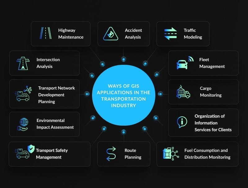
Thus, the descriptions of a few GIS applications in transportation are as follows.

  1. HIGHWAY MAINTENANCE: The emergence of geographic information systems has made highway maintenance easier and more affordable during the past few years. Real-time imagery of highways can be captured by satellites, highlighting problematic regions. GIS also provides a variety of digital maps to the government and other pertinent authorities so they may make decisions. GIS databases may be fed with information about roadway structures and accessible from anywhere.
  2. ACCIDENT ANALYSIS: It is simple to combine satellite image systems and CCTV in most cities and towns with GIS. Location addressing is used to alert emergency responders of an accident so they can provide assistance. In the case of an accident, GIS might serve as a source for a report.
  3. TRAFFIC MODELLING: The world’s cities are crowded with automobiles. Heavy traffic and difficult-to-manage traffic bottlenecks are caused by the government’s inability to regulate traffic adequately. The majority of nations are switching to computer systems for traffic management and structural design in response to the profound advancements in computer technology. With regard to traffic management, GIS has provided excellent options for the various extensive road networks found in cities and towns. Since only the greatest road, rail, and aviation designs are built, this has shown to reduce traffic. In addition to keeping an eye on these transportation networks while they are being created, GIS also provides traffic monitoring and visualization services.
  4. ROUTE PLANNING: The routes on which new projects are to be set out must be approved by field specialists before any new roads or railroad lines can be built. Longer routes, such as those using roads and railroads, will require more resources and increase trip times. Road and rail engineers are required to find the quickest and most effective ways when navigating roads or rail networks. Longer routes cost more in petrol, hence the user or citizen loses out on road money. Thus, it is necessary to realize shorter, safer, and more effective pathways. However, if manual methods are employed, it becomes challenging to identify the optimal route. When it comes to drainage, soil characteristics, and uneven terrain, GIS is the most appropriate tool to use.
  5. ENVIRONMENTAL IMPACT ASSESSMENT: On the land, roads, railroads, ports, and airports are typically constructed. Certain structures built in conjunction with transportation amenities may have an adverse effect on wildlife or human life. Building a railroad or roadway across a game park or extremely close to a body of water is a good example. Therefore, the environment is an element that needs to be taken into account because it provides a home for both humans and other living things. As projections of what may occur if a particular infrastructure was launched in a particular location are elaborated, GIS steps in to provide assistance. Some people think of pipelines as a way to transfer petroleum products. Aquatic animals die as a result of pipeline leaks. As a result, pipeline transportation of petroleum and its products is another duty carried out with appropriate GIS integration, since the environment would be most negatively impacted in the event of an error.
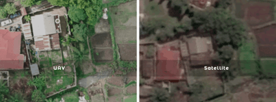
  6. CONSTRUCTION MANAGEMENT: Before beginning actual building, structure simulations must be carried out utilizing GIS related software for airports. The design and modeling process includes the creation of three-dimensional images. Drone technology can be combined with GIS during construction to aid in the visualization of work in progress. After that, mistakes can be fixed, and a variety of land properties are fed into GIS for more planning. Moreover, design templates that describe potential projects like highways, airports, or ports can be made possible with the usage of GIS.
  7. TRANSPORT SAFETY MANAGEMENT: Regulations and public education about the proper use of specific transportation facilities can both benefit from the information gathered from various transport structures. For improved communication between vehicles and pedestrians attempting to cross highways, crossing points including railroad crossing points can be integrated with GIS. In order to identify the causes of accidents, GIS is also used to study areas that are deemed “black spots” that are prone to mishaps.

GIS IN PUBLIC HEALTH

The vital field of public health works to raise community well-being on a global scale. Technological developments have had a significant impact on public health professionals’ job methods over time. Geographic Information Systems (GIS), which integrate specialist software with geospatial data to deliver insightful analysis, is one such breakthrough that has completely transformed the profession. GIS has shown to be a very useful technology for mapping diseases in public health.

The Impact of GIS on Disease Surveillance

A key component of public health is disease monitoring, which directs efforts toward prevention and control, tracks illness trends, and assists in the identification of outbreaks. GIS offers a strong foundation for disease surveillance that makes it possible to monitor and analyze health data in real time.

Public health experts can monitor the spread of diseases, pinpoint high-risk locations, and distribute resources appropriately by utilizing GIS capabilities. For instance, GIS made it easier to see infection hotspots during the COVID-19 pandemic, which assisted authorities in making decisions about the implementation of focused interventions and public health campaigns.

GIS is essential for tracking and monitoring illnesses as well as for comprehending the fundamental causes of disease spread. Comprehensive investigation of illness patterns is made possible by GIS by combining data from multiple sources, including socioeconomic indicators, environmental data, and demographic data.

Real-time data from many sources, including environmental sensors, test results, and medical records, can be integrated with GIS. Early detection of possible outbreaks is made possible by the integration of data sources, which offers a comprehensive picture of illness patterns.

GIS can be used, for instance, to track the occurrence of vector-borne illnesses like dengue fever and malaria by examining data from weather patterns, human case records, and mosquito capturing stations. To stop the spread of these diseases, public health officials can identify high-density disease vector locations with conducive environmental conditions and target vector control efforts accordingly. The assessment of methods for disease prevention and control can also be aided by GIS. GIS can offer important insights into the efficacy of interventions by evaluating their effects, such as immunization campaigns or health education initiatives.

All things considered, GIS has transformed illness monitoring by offering a thorough and dynamic method of comprehending and battling diseases. Because of its capacity to show disease trends, integrate and evaluate heterogeneous datasets, and facilitate evidence-based decision-making, it has become an essential tool for public health professionals around the globe.

GIS IN AGRICULTURE

Precision farming combines cutting-edge modern technologies with a developed agricultural sector. With the advancement of robotics, GPS, and unmanned aerial vehicles (UAV), many farm activities are now mechanized. GIS is a crucial part of automated field operations, which are sometimes referred to as satellite farming or precision agriculture. Utilizing soil resources and outside data sources more effectively at each location is made possible by precision farming. Spatial data, including an examination of spatial variability, and simulation models for the categorization of the activities that take place are essential for precision agricultural research. Data storage, analysis, and presentation systems for spatial information are known as geographic information systems, or GIS.

GIS IN AGRICULTURE

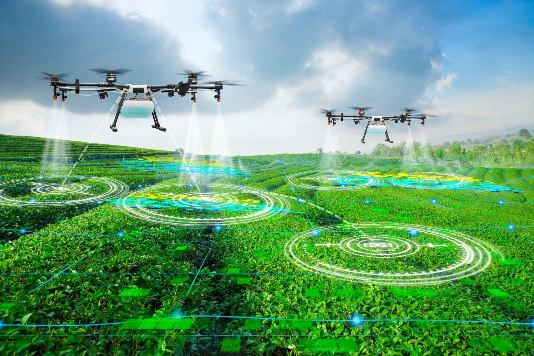
GPS-based tools are used in precision farming for crop scouting, yield mapping, soil testing, field mapping, tractor navigation, and farm organization. When working in low visibility environments like rain, dust, or fog, farmers can use GPS. GPS and GIS can be used to collect the data needed to improve the usage of land and water.
Improved use of fertilizer and organic manure, determining the economic threshold for managing weed and pest infestations, and conserving resources for use by future generations are all ways that farmers can increase their profits. Crop specialists use tough data gathering devices with GPS for precise positioning to map weed, bug, and pest issues in the field. Problem areas with crop pests can be located and mapped to inform recommendations for future management techniques. These applications includes;

  1. Crop yield mapping and estimation
  2. Crop health and monitoring
  3. Crop suitability assessment studies
  4. Irrigated landscape modeling
  5. Analysis of soil and irrigation reforms
  6. Erosion detection models and remediation
  7. Agricultural mapping for LULC
  8. Change detection studies
  9. Land degradation assessment


RECENT ACTIVITIES AND PROJECT...

URABN HEAT ISLAND EFFECT IN CALABAR MUNICIPAL

URABN HEAT ISLAND EFFECT IN CALABAR MUNICIPAL

ANALYZING URBANIZATION TRENDS IN KANO STATE, NIGERIA USING NIGHTTIME LIGHTS REMOTE SENSING DATA

ANALYZING URBANIZATION TRENDS IN KANO STATE, NIGERIA USING NIGHTTIME LIGHTS REMOTE SENSING DATA

COMPREHENSIVE OFFSHORE SURVEILLANCE AND MARITIME INFRASTRUCTURE MONITORING

COMPREHENSIVE OFFSHORE SURVEILLANCE AND MARITIME INFRASTRUCTURE MONITORING

Comprehensive Aerial Survey and Mapping for Golf Course Asset Management at Lakowe Golf Lake

Comprehensive Aerial Survey and Mapping for Golf Course Asset Management at Lakowe Golf Lake

Professional Drone Training Program for Enhanced Corporate Security Operations at Sahara Group

Professional Drone Training Program for Enhanced Corporate Security Operations at Sahara Group

Advanced Aerial Topographic Survey and Mapping for Land Development in Ogun State

Advanced Aerial Topographic Survey and Mapping for Land Development in Ogun State

Precision RGB and Thermal Imaging Revolutionizes Solar Infrastructure Inspection In Enugu

Precision RGB and Thermal Imaging Revolutionizes Solar Infrastructure Inspection In Enugu

Advanced Drone-Based Topographic Survey for Precision Land Development Planning

Advanced Drone-Based Topographic Survey for Precision Land Development Planning

Mapping the Future: Comprehensive Area Survey Transforms Land Development in Akure

Mapping the Future: Comprehensive Area Survey Transforms Land Development in Akure

Precision Topographical Survey and Mapping for Smarter Infrastructure Planning

Precision Topographical Survey and Mapping for Smarter Infrastructure Planning

Precision Drone Volumetric Surveys: How Purechem Industries Optimized Mineral Stockpile Management

Precision Drone Volumetric Surveys: How Purechem Industries Optimized Mineral Stockpile Management

Advanced Mapping & Environmental Survey for Ilubirin Property, Lagos Island

Advanced Mapping & Environmental Survey for Ilubirin Property, Lagos Island

Unveiling the Invisible: LiDAR Technology Transforms Terrain Analysis in Abeokuta North

Unveiling the Invisible: LiDAR Technology Transforms Terrain Analysis in Abeokuta North

 DETAILED AERIAL, LAND SURVEY AND GIS ANALYSIS FOR ADVANCED REAL ESTATE DEVELOPMENT

 DETAILED AERIAL, LAND SURVEY AND GIS ANALYSIS FOR ADVANCED REAL ESTATE DEVELOPMENT

Professional Drone Mapping and GIS Training For ETA-ZUMA Mining Company

Professional Drone Mapping and GIS Training For ETA-ZUMA Mining Company

Installation of Intelligent Traffic Lights

Installation of Intelligent Traffic Lights

Geological Report on a Mining/Exploration Survey

Geological Report on a Mining/Exploration Survey

Drone Survey and Mapping of Shaishen Foods Limited

Drone Survey and Mapping of Shaishen Foods Limited

Lidar Topographic Mapping Project

Lidar Topographic Mapping Project

Geophysical/hydrogeophysical Studies for Groundwater Development

Geophysical/hydrogeophysical Studies for Groundwater Development

Togo Digital Terrain Model Project

Togo Digital Terrain Model Project

Drone Mapping of Parts of Lome Rail Line for Graceland Energy Located at Lome Togo

Drone Mapping of Parts of Lome Rail Line for Graceland Energy Located at Lome Togo

Drone/land Survey of Pure-chem Industrial Limited, Ogun State.

Drone/land Survey of Pure-chem Industrial Limited, Ogun State.

Drone Inspection/survey of Southern Lake Estate, Chevron, Lekki, Lagos State

Drone Inspection/survey of Southern Lake Estate, Chevron, Lekki, Lagos State

Anniversary-Workshop on the Application of Remote Sensing and Drone Technology in GIS -Abuja

Anniversary-Workshop on the Application of Remote Sensing and Drone Technology in GIS -Abuja

Topographic Mapping of Oyo State

Topographic Mapping of Oyo State

Topographic Mapping of Part of the Local Government Areas in Oyo State

Topographic Mapping of Part of the Local Government Areas in Oyo State

Topographic Mapping of Part of Kwara, Ekiti and Kogi State Local Government Area

Topographic Mapping of Part of Kwara, Ekiti and Kogi State Local Government Area

Political Map of South West, Nigeria Located in Nigeria

Political Map of South West, Nigeria Located in Nigeria

Topographic Mapping of Parts of Niger State Located at Niger State, Nigeria

Topographic Mapping of Parts of Niger State Located at Niger State, Nigeria

Topographic Mapping of Part of Kwara, Ekiti, and Kogi State Local Government Area Located in Nigeria

Topographic Mapping of Part of Kwara, Ekiti, and Kogi State Local Government Area Located in Nigeria

Topographic Mapping of Part of Kwara State Local Government Area Located at Kwara State Nigeria

Topographic Mapping of Part of Kwara State Local Government Area Located at Kwara State Nigeria

Flood Analysis of Amuwo-odofin Orthophoto.

Flood Analysis of Amuwo-odofin Orthophoto.

Site Inspection Using Drone of Water Corporation Located at Oke-aro Agege

Site Inspection Using Drone of Water Corporation Located at Oke-aro Agege

24,000 meter Lome Rail Line for Drone Mapping, Graceland Energy Located at Lome, Togo

24,000 meter Lome Rail Line for Drone Mapping, Graceland Energy Located at Lome, Togo

10 Drone Inspection Traffic Signal in Lagos

10 Drone Inspection Traffic Signal in Lagos

Lagos October 1st Free GIS Training Workshop

Lagos October 1st Free GIS Training Workshop

Osun state parcel project

Osun state parcel project

Drone Mapping & Vectorization Of Abu-allied Farm

Drone Mapping & Vectorization Of Abu-allied Farm

Proposal for aerial deployment, tracking and monitoring of threats in victoria island phase 1 and ikoyi phase 2, nigeria

Proposal for aerial deployment, tracking and monitoring of threats in victoria island phase 1 and ikoyi phase 2, nigeria

Jabi Lake Mall Solar Inspection – Abuja

Jabi Lake Mall Solar Inspection – Abuja

Ground Control and Drone Survey for Mast 3D Modeling

Ground Control and Drone Survey for Mast 3D Modeling

Telecom Drone 3D and 2D Modeling of Cellsite

Telecom Drone 3D and 2D Modeling of Cellsite

Free GIS Spatial Analysis Training (Lagos Branch)

Free GIS Spatial Analysis Training (Lagos Branch)

800 Building Plots Aerial Capture and Delineation for Database. Greenfield Estate

800 Building Plots Aerial Capture and Delineation for Database. Greenfield Estate

100 Hectares Aerial Survey with Differential GPS of High Accuracy

100 Hectares Aerial Survey with Differential GPS of High Accuracy

Protected: Nigeria Crime Report and Dashboard

Protected: Nigeria Crime Report and Dashboard

Drone Survey and Mapping – Victoria Island  Copy

Drone Survey and Mapping – Victoria Island Copy

Akwa-Ibom 500 Hectares Drone Survey and Mapping in Nigeria

Akwa-Ibom 500 Hectares Drone Survey and Mapping in Nigeria

Ground Control Establishment – Republic of the Niger – Kano, Kastina, Jigawa, Kaduna

Ground Control Establishment – Republic of the Niger – Kano, Kastina, Jigawa, Kaduna

Drone Survey and Mapping – Victoria Island

Drone Survey and Mapping – Victoria Island

Control Point Establishment – DGPS

Control Point Establishment – DGPS

Land Survey – Northern Nigeria

Land Survey – Northern Nigeria

Biodiversity Mapping – Sweden

Biodiversity Mapping – Sweden

Flood Impact Mapping – United Kingdom

Flood Impact Mapping – United Kingdom

M and E GIS Dashboard for Control Establishment Project

M and E GIS Dashboard for Control Establishment Project

Geodatabase Management System Training For National Boundary Commission

Geodatabase Management System Training For National Boundary Commission

Nigeria Topographic Map – Project

Nigeria Topographic Map – Project

Abuja Training on Introduction to GIS

Abuja Training on Introduction to GIS

200 Hectares Land and Drone Survey – Lagos Nigeria

200 Hectares Land and Drone Survey – Lagos Nigeria

Inspection of 30 hectares drainage

Inspection of 30 hectares drainage

Drainage Drone Mapping and Surveying in Lagos Nigeria

Drainage Drone Mapping and Surveying in Lagos Nigeria

GIS Cadastral Mobile Application

GIS Cadastral Mobile Application

Abuja Topographical Map – HD GIS Mapping

Abuja Topographical Map – HD GIS Mapping

Ground Topography Survey (Lagos Island)

Ground Topography Survey (Lagos Island)

2.7km2 Topography Survey in Snake Island

2.7km2 Topography Survey in Snake Island

GIS Masterclass

GIS Masterclass

Sokoto Contour Map

Sokoto Contour Map

NDVI Vegetation Assessment in Lagos State

NDVI Vegetation Assessment in Lagos State

Lagos drone training master class

Lagos drone training master class

Ifako drone topographic survey and mapping

Ifako drone topographic survey and mapping

CMD Lagos 3D mapping aerial modeling

CMD Lagos 3D mapping aerial modeling

GIS and Drone Masterclass

GIS and Drone Masterclass

Drone aerial survey and mapping – Lagos Island _ Somolu

Drone aerial survey and mapping – Lagos Island _ Somolu

Covid-19 | Nigeria Data Visualisation

Covid-19 | Nigeria Data Visualisation

Benue Flood Analysis

Benue Flood Analysis

Aerial photography Ile-Ife Osun State

Aerial photography Ile-Ife Osun State

Kenya Forest Project

Kenya Forest Project

Tunsun Consultants Ltd

Tunsun Consultants Ltd

Introduction To Gis In Maritime at the National Boundary Commission

Introduction To Gis In Maritime at the National Boundary Commission

Training on GIS and Drone Mapping (batch-4 & 5)

Training on GIS and Drone Mapping (batch-4 & 5)

Osun Flood Mapping

Osun Flood Mapping

Lahass International Limited

Lahass International Limited

Linguistic Association of Nigeria

Linguistic Association of Nigeria

West African Indexing Services

West African Indexing Services

Lagos Ikeja Road Network Map

Lagos Ikeja Road Network Map

LASU Land Regularisation Portal

LASU Land Regularisation Portal

Lingua Plus International

Lingua Plus International

Lagferry Web Route

Lagferry Web Route

YOU MAY ALSO LIKE...

COURSES

Explore Geoinfotech courses and establish a strong foundation of knowledge and skills to be productive with the latest Technology.

Spatial Analysis using ArcGIS

Learn essential concepts and a standard workflow you can apply to any spatial analysis project.
Duration: 2 Weekends (Every Friday 2pm and Saturday 10am)
Package: Field Experience, 100% Hands-on practical, jotter, Biro and Software
Others: Test, Exam and Certificate

Find out more

Managing Geospatial Data in ArcGIS

This course takes you on an in-depth exploration of the geodatabase, the native data storage format for ArcGIS software...
Duration: 2 Weekends (Every Friday 2pm and Saturday 10am)
Package: Field Experience, 100% Hands-on practical, jotter, Biro and Software
Others: Test, Exam and Certificate

Find out more

Drone Pilot for Beginners to Professional

The Drone Professional Training course is a comprehensive program designed to equip participants with the necessary skills and knowledge to operate drones effectively and safely in a professional setting.
Duration: 3 Weekends (Every Friday 2pm and Saturday 10am)
Package: Field Experience, 100% Hands-on practical, jotter, Biro and Software Others, Test, Exam and Certificate.

Find out more
Training Venue Available in,Lagos and Abuja100253Nigeria
+ Google Map

Differential GPS (DGPS) Land Surveying Training

Professional 2 weekends ▪ Field Experience 5.0 (100% Practical) ▪ Exam & CertificateFree Software and AppsHands on Practical and Field…

Find out more