 Port Harcourt sits within an important oil and gas environment with pipelines, production facilities, wellheads and other critical energy infrastructure operating across the region. Monitoring these assets requires accurate information and regular observation.
Pipeline and wellhead surveillance in Port Harcourt can help operators improve visibility across their infrastructure using drones, GIS, remote sensing and aerial intelligence.
Why Pipeline and Wellhead Surveillance Matters
Pipelines and wellheads operate across different environments. Pipeline corridors can extend through communities, wetlands, roads and industrial areas, while wellheads may be located in areas that are difficult to access regularly.
Ground inspections remain important, but aerial technology can provide an additional layer of visibility. Drones can capture high-resolution imagery across selected assets and surrounding areas, helping teams document conditions and identify locations that require closer assessment.
Geoinfotech provides professional drone services in Port Harcourt for surveying, mapping, inspection, surveillance and aerial data collection.
Drone Surveillance for Pipeline Corridors
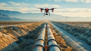
Pipeline networks cover large areas, making consistent monitoring challenging. Drone technology can support aerial inspection of pipeline corridors and rights-of-way while reducing dependence on extensive ground observation.
Geoinfotech’s drone services for oil and gas combine UAV technology with GIS, LiDAR, thermal imaging and photogrammetry. These capabilities can support infrastructure monitoring, inspection, mapping and documentation.
Repeated drone surveys can also create a visual record of pipeline corridors. Organizations can compare observations from different periods and identify changes that may require further investigation.
Wellhead Monitoring From the Air
Wellheads are important production assets that require appropriate monitoring and inspection. Their locations can make routine visual assessment difficult, particularly where access is limited or environmental conditions are challenging.
Aerial imagery can provide an overview of the wellhead and its surrounding environment. Depending on project requirements, specialized sensors can provide additional information for inspection and environmental assessment.
Geoinfotech’s experience in drone surveillance for oil and gas facilities supports applications across pipelines, facilities and other oil and gas infrastructure.
Connecting Surveillance Data With GIS
Drone imagery becomes more valuable when it is connected to accurate geographic information.
GIS can link observations to specific pipeline sections, wellheads, facilities and surrounding features. This allows organizations to build a central spatial record of their assets and monitoring activities.
Geoinfotech’s GIS services in Nigeria can complement aerial surveys by providing mapping, spatial analysis and geospatial data management.
A typical workflow can therefore follow:
Map → Monitor → Capture → Analyze → Report
This creates a more organized approach to infrastructure surveillance.
Real-Time Aerial Intelligence
For some operations, post-flight imagery may not provide information quickly enough. Real-time aerial monitoring can give authorized stakeholders a current view during an active surveillance or inspection operation.
Geoinfotech’s drone livestreaming services provide live aerial video capabilities for suitable infrastructure and monitoring applications.
This can help decision-makers access visual information remotely and determine when further assessment may be required.
A Smarter Approach to Oil and Gas Asset Monitoring
Pipeline and wellhead surveillance should not rely on a single technology. Drones can provide detailed aerial observations, satellites can provide broader coverage, GIS can organize spatial information, and field teams can provide ground-level verification.
When these technologies work together, organizations gain a clearer picture of their infrastructure and its surrounding environment.
For oil and gas operators in Port Harcourt, Geoinfotech combines drone technology, GIS, remote sensing and aerial intelligence to support modern infrastructure monitoring.
If you need pipeline and wellhead surveillance in Port Harcourt, Geoinfotech can help transform aerial data into useful information for inspection, monitoring and asset management.