
Introduction To Remote Sensing
Remote Sensing is the art and science of obtaining information about an object or feature without physically coming into contact. The data collected can be of many forms such as variations in acoustic wave distributions (sonar), force distributions (gravity meter), electromagnetic energy distributions (eye), etc. NOAA refer to remote sensing as the science of obtaining information about objects or areas from a distance, typically from aircraft or satellites. On the other hand, The United State Geological Survey (USGS) defined remote sensing as the process of detecting and monitoring the physical characteristics of an area by measuring its reflected and emitted radiation at a distance (typically from satellite or aircraft).
The term remote sensing is often wrongly applied to satellite-borne imaging of the earth’s surface only. Remote sensing is the common name for all methods used to collect data at a distance from the object under study by some kind of recording device. The use of remote sensing techniques is increasing rapidly, finding new fields of application as technology advances in developing the remote sensing systems (). Special cameras collect remotely sensed images, which help researchers “sense” things about the Earth. Some examples are:
- Cameras on satellites and airplanes take images of large areas on the Earth’s surface, allowing us to see much more than we can see when standing on the ground.
- Sonar systems on ships can be used to create images of the ocean floor without needing to travel to the bottom of the ocean.
- Cameras on satellites can be used to make images of temperature changes in the oceans.
Remote sensors collect data by detecting the energy reflecting from Earth. These sensors can be on satellites or mounted on aircraft. Figure 1 is an illustration of remote sensing
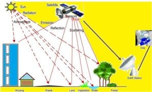
Figure 1: Remote sensing (Source: https://gisrsstudy.com/remote-sensing/)
History of Remote Sensing
An ordinary camera is a simple remote sensing system. A camera used during the end of the 19th century for e.g. military reconnaissance, having the obvious advantage over simple visual inspection in the fact that it produces an image that can be studied and reproduced in several copies. Since the late 1920s, aerial photography has been an important tool in all kinds of mapping and planning work. During World War II, two new remote sensing methods were developed, the sonar and the radar. After World War II, several systems have been developed for different types of electromagnetic radiation. Remote sensing systems based on electronic radiation detectors are not obviously image generating systems, that is, the result is not an image, but rather a set of numbers stored in a computer compatible format. The stored data can often be transformed into an image by a computer using dedicated software (Martensson, n.d).
Remote Sensing is a multidisciplinary field that involves the acquisition, processing, and interpretation of data collected from a distance, typically using satellite or airborne sensors. It has become an essential tool for studying the Earth’s environment, monitoring natural resources, and supporting decision-making in various sectors such as agriculture, urban planning, disaster management, and public health (Jensen, 2015). The rapid development of satellite technologies and sensor systems has significantly increased the availability of high-resolution spatial data. This has enhanced the capability to monitor environmental changes, detect hazards, and analyze spatial patterns over time.
Principles of Remote Sensing
There are three major principles of remote sensing which are: Electromagnetic Radiation (EMR), Interaction of EMR with Matter, and spectral signature.
3.1 Electromagnetic Radiation (EMR)
Remote sensing is fundamentally based on the concept of electromagnetic radiation or electromagnetic energy. The electromagnetic radiation is the energy that travels in the form of waves at the speed of light and is characterized by its wavelength and frequency (Figure 2). In other words electromagnetic radiation is the energy that propagates in the form of an advancing interaction between electric and magnetic fields. It travels with the velocity of light. Visible light, ultraviolet, and infrared rays, heat, radio waves, X-rays all are different forms of electromagnetic energy. The primary source of EMR in passive remote sensing is the Sun, while active remote sensing systems generate their own energy (e.g., radar and LiDAR).
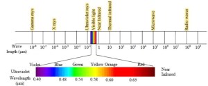
Figure 2a: Wavelength/ Spectrum of Electromagnetic Radiation
µm represented as Microns, also known as micrometers are a length of measurement equal to one millionth of a meter. (1,000µm is equal to 1mm.)
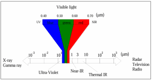
Figure 2b: Spectrum of Electromagnetic Radiation (Source: Martensson, n.d)
3.2 Interaction of EMR with Matter
When electromagnetic radiation reaches the Earth’s surface, it interacts with materials in three main ways:
- Reflection: Energy is bounced back from the surface
- Absorption: Energy is absorbed and convert into other forms
- Transmission: Energy passes through the material
The proportion of these interactions varies depending on the physical and chemical properties of the material, forming the basis for object identification.
3.3 Spectral Signature
A spectral signature is the unique pattern of reflectance or emittance of an object across different wavelengths. For example:
- Vegetation reflects strongly in the near-infrared region
- Water absorbs most radiation and appears dark
- Bare soil exhibits moderate reflectance
These unique signatures allow analysts to distinguish between different surface features (Lillesand et al., 2015). Thus, Figure 3a and 4b show remote sensing image: a Lidar (Light Detection and Ranging) image created with data collected by NOAA’s National Geodetic Survey.
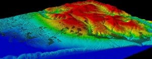
Figure 3a: Lidar Image Created with Data collected by NOAA’s National Geodetic Survey.
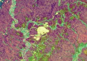
Figure 3b: Remote Sensing Image
Martensson U. (n.d). Introduction to Remote Sensing and Geographical Information Systems.
U.S. Geological Survey (USGS). What is remote sensing and what is it used for?. USGS, U.S. Department of the Interior. https://www.usgs.gov/faqs/what-remote-sensing-and-what-it-used
Lillesand, T., Kiefer, R. W., & Chipman, J. (2015). Remote Sensing and Image Interpretation. Wiley.
Richards, J. A. (2013). Remote Sensing Digital Image Analysis. Springer.
Contact Geoinfotech Resources Limited for professional and exceptional remote sensing professional certification, training and remote sensing data. Geoinfotech Resources Limited is a surveying and GIS company that is well equipped for rendering services in different sectors including remote sensing application in agriculture, land survey, environmental monitoring, oil and gas survey/inspection, education, estate planning and management, construction, engineering etc. We are also famous and reliable suppliers of GIS and surveying instruments to individuals and organisations within Nigeria and abroad.


