Document

REMOTE SENSING TECHNOLOGY – An Overview

1. Introduction To Remote Sensing

Remote sensing is the science and art of obtaining information about an object, area, or phenomenon without physically touching it. Instead of direct contact, information is gathered using sensors mounted on satellites, aircraft, drones, ships, or other platforms. The National Oceanic and Atmospheric Administration defines remote sensing as the process of obtaining information about objects or areas from a distance, typically using satellites or aircraft. Similarly, the United States Geological Survey describes remote sensing as the detection and monitoring of physical characteristics of an area through the measurement of reflected and emitted radiation.

Remote sensing technology allows scientists and professionals to:

  • Monitor environmental changes
  • Analyze land use and land cover
  • Detect natural disasters
  • Conduct mapping and surveying
  • Support urban planning and agriculture

Remote sensing is not limited to satellite imagery alone. It includes all methods of collecting information from a distance using recording devices and sensors.

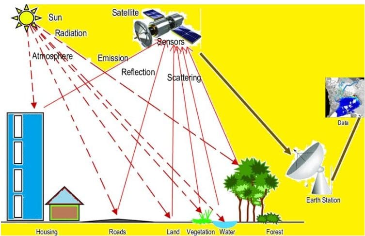
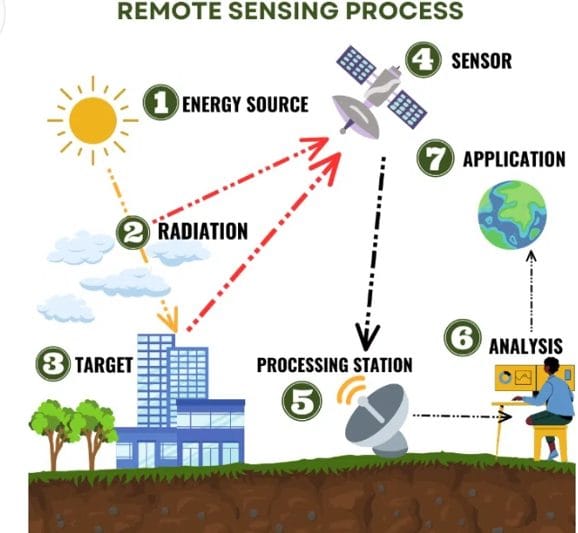
   Figure 1: Remote sensing (Source: https://gisrsstudy.com/remote-sensing/)

Examples of Remote Sensing Applications

Remote sensing systems are used in many industries and environments:

  • Satellite and aerial cameras capture images of the Earth’s surface for mapping and environmental monitoring
  • Sonar systems create images of the ocean floor without underwater exploration
  • Thermal sensors monitor ocean temperature variations
  • Drones collect high-resolution imagery for surveying and construction projects

Sensors gather data by detecting electromagnetic energy reflected or emitted from the Earth’s surface.

2. History of Remote Sensing

An ordinary camera is a simple remote sensing system. A camera was used at the end of the 19th century, for e.g. military reconnaissance, having the obvious advantage over simple visual inspection in the fact that it produced an image that could be studied and reproduced in several copies. Since the late 1920s, aerial photography has been an important tool in all kinds of mapping and planning work. During World War II, two new remote sensing methods were developed, sonar and radar. After World War II, several systems were developed for different types of electromagnetic radiation. Remote sensing systems based on electronic radiation detectors are not obviously image-generating systems; that is, the result is not an image, but rather a set of numbers stored in a computer-compatible format. The stored data can often be transformed into an image by a computer using dedicated software (Martensson, n.d). Remote Sensing is a multidisciplinary field that involves the acquisition, processing, and interpretation of data collected from a distance, typically using satellite or airborne sensors. It has become an essential tool for studying the Earth’s environment, monitoring natural resources, and supporting decision-making in various sectors such as agriculture, urban planning, disaster management, and public health (Jensen, 2015).

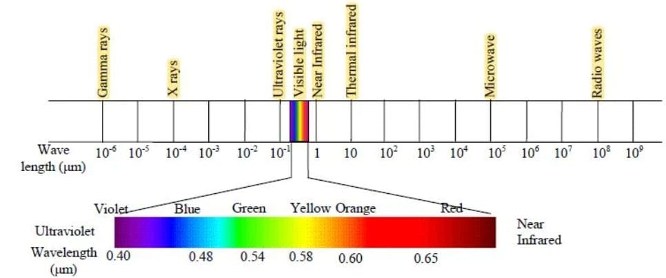
  Figure 2a: Wavelength/ Spectrum of Electromagnetic Radiation.

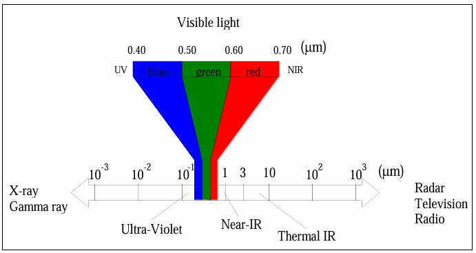
Figure 2b: Spectrum of Electromagnetic Radiation (Source: Martensson, n.d)

3. Principles of Remote Sensing

There are three major principles of remote sensing, which are: Electromagnetic Radiation (EMR), Interaction of EMR with Matter, and spectral signature.

3.1 Electromagnetic Radiation (EMR)

Remote sensing is fundamentally based on the concept of electromagnetic radiation or electromagnetic energy. The electromagnetic radiation is the energy that travels in the form of waves at the speed of light and is characterized by its wavelength and frequency (Figure 2). In other words, electromagnetic radiation is the energy propagated in the form of an advancing interaction between electric and magnetic fields. It travels at the velocity of light. Visible light, ultraviolet, and infrared rays, heat, radio waves, and X-rays are all different forms of electromagnetic energy. The primary source of EMR in passive remote sensing is the Sun, while active remote sensing systems generate their own energy (e.g., radar and LiDAR).

3.2 Interaction of EMR with Matter

When electromagnetic radiation reaches the Earth’s surface, it interacts with materials in three main ways:

  • Reflection: Energy is bounced back from the surface
  • Absorption: Energy is absorbed and converted into other forms
  • Transmission: Energy passes through the material

The proportion of these interactions varies depending on the physical and chemical properties of the material, forming the basis for object identification.

 3.3 Spectral Signature

A spectral signature is the unique pattern of reflectance or emittance of an object across different wavelengths. For example:

  • Vegetation reflects strongly in the near-infrared region
  • Water absorbs most radiation and appears dark
  • Bare soil exhibits moderate reflectance

These unique signatures allow analysts to distinguish between different surface features (Lillesand et al., 2015). Thus, Figures 3a and 4b show a remote sensing image: a Lidar (Light Detection and Ranging) image created with data collected by NOAA’s National Geodetic Survey.

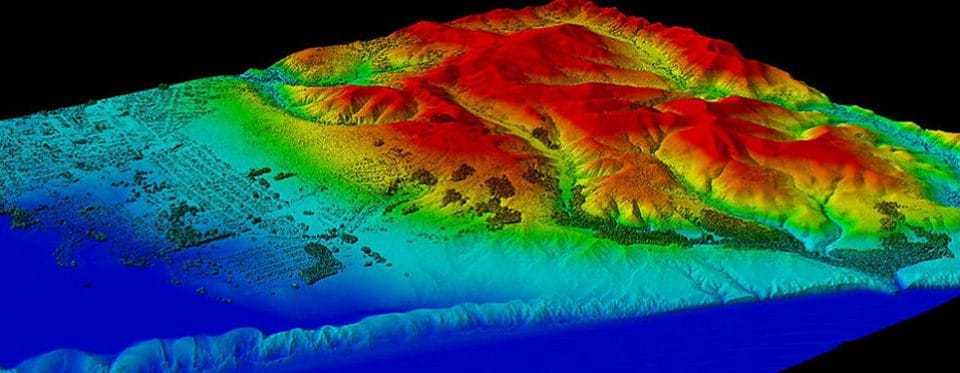
Figure 3a: Lidar Image Created with Data collected by NOAA’s National Geodetic Survey.

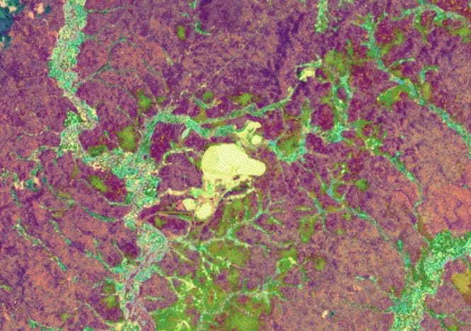
     Figure 3b: Remote Sensing Image

Importance of Remote Sensing in Nigeria

Remote sensing is becoming increasingly important in Nigeria due to growing demand for:

  • Urban planning
  • Agricultural monitoring
  • Flood risk analysis
  • Environmental protection
  • Infrastructure development

Government agencies, universities, NGOs, and private geospatial firms now rely heavily on:

  • Satellite imagery
  • Drone mapping
  • GIS analysis
  • Geospatial intelligence systems

FAQs

What is remote sensing?

Remote sensing is the process of collecting information about objects or areas from a distance using sensors mounted on satellites, aircraft, drones, or other platforms.

What are the main principles of remote sensing?

The three major principles are electromagnetic radiation, interaction of EMR with matter, and spectral signatures.

What is a spectral signature?

A spectral signature is the unique reflectance pattern of an object across different wavelengths of electromagnetic radiation.

What is the difference between active and passive remote sensing?

Passive remote sensing uses natural energy sources like sunlight, while active remote sensing systems generate their own energy.

What are the applications of remote sensing?

Applications include agriculture, environmental monitoring, mapping, surveying, disaster management, urban planning, and infrastructure inspection.

REFERENCES

Martensson U. (n.d). Introduction to Remote Sensing and Geographical Information Systems.
U.S. Geological Survey
(USGS). What is remote sensing, and what is it used for?. USGS, U.S. Department of the Interior. https://www.usgs.gov/faqs/what-remote-sensing-and-what-it-used

Lillesand, T., Kiefer, R. W., & Chipman, J. (2015). Remote Sensing and Image Interpretation. Wiley.

Richards, J. A. (2013). Remote Sensing Digital Image Analysis. Springer.

RECENT ACTIVITIES AND PROJECT...

DRONE TOPOGRAPHIC SURVEY: HOW GEOINFOTECH SUPPORTED LAND DEVELOPMENT PLANNING IN IGABI, KADUNA STATE

DRONE TOPOGRAPHIC SURVEY: HOW GEOINFOTECH SUPPORTED LAND DEVELOPMENT PLANNING IN IGABI, KADUNA STATE

PRECISION TOPOGRAPHIC SURVEY AND MAPPING: HOW GEOINFOTECH SUPPORTED MINING SITE PLANNING IN JOS THROUGH DRONE TECHNOLOGY

PRECISION TOPOGRAPHIC SURVEY AND MAPPING: HOW GEOINFOTECH SUPPORTED MINING SITE PLANNING IN JOS THROUGH DRONE TECHNOLOGY

ROUTE TOPO SURVEY AND MAPPING: HOW GEOINFOTECH SUPPORTED THE ENUGU CABLE CAR PROJECT THROUGH ADVANCED GEOSPATIAL SOLUTIONS

ROUTE TOPO SURVEY AND MAPPING: HOW GEOINFOTECH SUPPORTED THE ENUGU CABLE CAR PROJECT THROUGH ADVANCED GEOSPATIAL SOLUTIONS

BOUNDARY SURVEY AND ENCROACHMENT ANALYSIS: HOW EGBIN POWER PLANT IMPROVED LAND MANAGEMENT THROUGH GEOSPATIAL TECHNOLOGY

BOUNDARY SURVEY AND ENCROACHMENT ANALYSIS: HOW EGBIN POWER PLANT IMPROVED LAND MANAGEMENT THROUGH GEOSPATIAL TECHNOLOGY

DRONE APPLICATION IN AERIAL SURVEY AND MAPPING: HOW GEOINFOTECH ENHANCED AGRICULTURAL SITE PLANNING IN OSEFA THROUGH GEOSPATIAL TECHNOLOGY

DRONE APPLICATION IN AERIAL SURVEY AND MAPPING: HOW GEOINFOTECH ENHANCED AGRICULTURAL SITE PLANNING IN OSEFA THROUGH GEOSPATIAL TECHNOLOGY

AERIAL SURVEY AND MAPPING FOR AGRICULTURAL SITE PLANNING: HOW GEOINFOTECH IMPROVED AGRICULTURAL DEVELOPMENT IN ILORA THROUGH DRONE TECHNOLOGY

AERIAL SURVEY AND MAPPING FOR AGRICULTURAL SITE PLANNING: HOW GEOINFOTECH IMPROVED AGRICULTURAL DEVELOPMENT IN ILORA THROUGH DRONE TECHNOLOGY

URABN HEAT ISLAND EFFECT IN CALABAR MUNICIPAL

URABN HEAT ISLAND EFFECT IN CALABAR MUNICIPAL

ANALYZING URBANIZATION TRENDS IN KANO STATE, NIGERIA USING NIGHTTIME LIGHTS REMOTE SENSING DATA

ANALYZING URBANIZATION TRENDS IN KANO STATE, NIGERIA USING NIGHTTIME LIGHTS REMOTE SENSING DATA

COMPREHENSIVE OFFSHORE SURVEILLANCE AND MARITIME INFRASTRUCTURE MONITORING

COMPREHENSIVE OFFSHORE SURVEILLANCE AND MARITIME INFRASTRUCTURE MONITORING

Comprehensive Aerial Survey and Mapping for Golf Course Asset Management at Lakowe Golf Lake

Comprehensive Aerial Survey and Mapping for Golf Course Asset Management at Lakowe Golf Lake

Professional Drone Training Program for Enhanced Corporate Security Operations at Sahara Group

Professional Drone Training Program for Enhanced Corporate Security Operations at Sahara Group

Advanced Aerial Topographic Survey and Mapping for Land Development in Ogun State

Advanced Aerial Topographic Survey and Mapping for Land Development in Ogun State

Precision RGB and Thermal Imaging Revolutionizes Solar Infrastructure Inspection In Enugu

Precision RGB and Thermal Imaging Revolutionizes Solar Infrastructure Inspection In Enugu

Advanced Drone-Based Topographic Survey for Precision Land Development Planning

Advanced Drone-Based Topographic Survey for Precision Land Development Planning

Mapping the Future: Comprehensive Area Survey Transforms Land Development in Akure

Mapping the Future: Comprehensive Area Survey Transforms Land Development in Akure

Precision Topographical Survey and Mapping for Smarter Infrastructure Planning

Precision Topographical Survey and Mapping for Smarter Infrastructure Planning

Precision Drone Volumetric Surveys: How Purechem Industries Optimized Mineral Stockpile Management

Precision Drone Volumetric Surveys: How Purechem Industries Optimized Mineral Stockpile Management

Advanced Mapping & Environmental Survey for Ilubirin Property, Lagos Island

Advanced Mapping & Environmental Survey for Ilubirin Property, Lagos Island

Unveiling the Invisible: LiDAR Technology Transforms Terrain Analysis in Abeokuta North

Unveiling the Invisible: LiDAR Technology Transforms Terrain Analysis in Abeokuta North

 DETAILED AERIAL, LAND SURVEY AND GIS ANALYSIS FOR ADVANCED REAL ESTATE DEVELOPMENT

 DETAILED AERIAL, LAND SURVEY AND GIS ANALYSIS FOR ADVANCED REAL ESTATE DEVELOPMENT

Professional Drone Mapping and GIS Training For ETA-ZUMA Mining Company

Professional Drone Mapping and GIS Training For ETA-ZUMA Mining Company

Installation of Intelligent Traffic Lights

Installation of Intelligent Traffic Lights

Geological Report on a Mining/Exploration Survey

Geological Report on a Mining/Exploration Survey

Drone Survey and Mapping of Shaishen Foods Limited

Drone Survey and Mapping of Shaishen Foods Limited

Lidar Topographic Mapping Project

Lidar Topographic Mapping Project

Geophysical/hydrogeophysical Studies for Groundwater Development

Geophysical/hydrogeophysical Studies for Groundwater Development

Togo Digital Terrain Model Project

Togo Digital Terrain Model Project

Drone Mapping of Parts of Lome Rail Line for Graceland Energy Located at Lome Togo

Drone Mapping of Parts of Lome Rail Line for Graceland Energy Located at Lome Togo

Drone/land Survey of Pure-chem Industrial Limited, Ogun State.

Drone/land Survey of Pure-chem Industrial Limited, Ogun State.

Drone Inspection/survey of Southern Lake Estate, Chevron, Lekki, Lagos State

Drone Inspection/survey of Southern Lake Estate, Chevron, Lekki, Lagos State

Anniversary-Workshop on the Application of Remote Sensing and Drone Technology in GIS -Abuja

Anniversary-Workshop on the Application of Remote Sensing and Drone Technology in GIS -Abuja

Topographic Mapping of Oyo State

Topographic Mapping of Oyo State

Topographic Mapping of Part of the Local Government Areas in Oyo State

Topographic Mapping of Part of the Local Government Areas in Oyo State

Topographic Mapping of Part of Kwara, Ekiti and Kogi State Local Government Area

Topographic Mapping of Part of Kwara, Ekiti and Kogi State Local Government Area

Political Map of South West, Nigeria Located in Nigeria

Political Map of South West, Nigeria Located in Nigeria

Topographic Mapping of Parts of Niger State Located at Niger State, Nigeria

Topographic Mapping of Parts of Niger State Located at Niger State, Nigeria

Topographic Mapping of Part of Kwara, Ekiti, and Kogi State Local Government Area Located in Nigeria

Topographic Mapping of Part of Kwara, Ekiti, and Kogi State Local Government Area Located in Nigeria

Topographic Mapping of Part of Kwara State Local Government Area Located at Kwara State Nigeria

Topographic Mapping of Part of Kwara State Local Government Area Located at Kwara State Nigeria

Flood Analysis of Amuwo-odofin Orthophoto.

Flood Analysis of Amuwo-odofin Orthophoto.

Site Inspection Using Drone of Water Corporation Located at Oke-aro Agege

Site Inspection Using Drone of Water Corporation Located at Oke-aro Agege

24,000 meter Lome Rail Line for Drone Mapping, Graceland Energy Located at Lome, Togo

24,000 meter Lome Rail Line for Drone Mapping, Graceland Energy Located at Lome, Togo

10 Drone Inspection Traffic Signal in Lagos

10 Drone Inspection Traffic Signal in Lagos

Lagos October 1st Free GIS Training Workshop

Lagos October 1st Free GIS Training Workshop

Osun state parcel project

Osun state parcel project

Drone Mapping & Vectorization Of Abu-allied Farm

Drone Mapping & Vectorization Of Abu-allied Farm

Proposal for aerial deployment, tracking and monitoring of threats in victoria island phase 1 and ikoyi phase 2, nigeria

Proposal for aerial deployment, tracking and monitoring of threats in victoria island phase 1 and ikoyi phase 2, nigeria

Jabi Lake Mall Solar Inspection – Abuja

Jabi Lake Mall Solar Inspection – Abuja

Ground Control and Drone Survey for Mast 3D Modeling

Ground Control and Drone Survey for Mast 3D Modeling

Telecom Drone 3D and 2D Modeling of Cellsite

Telecom Drone 3D and 2D Modeling of Cellsite

Free GIS Spatial Analysis Training (Lagos Branch)

Free GIS Spatial Analysis Training (Lagos Branch)

800 Building Plots Aerial Capture and Delineation for Database. Greenfield Estate

800 Building Plots Aerial Capture and Delineation for Database. Greenfield Estate

100 Hectares Aerial Survey with Differential GPS of High Accuracy

100 Hectares Aerial Survey with Differential GPS of High Accuracy

Protected: Nigeria Crime Report and Dashboard

Protected: Nigeria Crime Report and Dashboard

Drone Survey and Mapping – Victoria Island  Copy

Drone Survey and Mapping – Victoria Island Copy

Akwa-Ibom 500 Hectares Drone Survey and Mapping in Nigeria

Akwa-Ibom 500 Hectares Drone Survey and Mapping in Nigeria

Ground Control Establishment – Republic of the Niger – Kano, Kastina, Jigawa, Kaduna

Ground Control Establishment – Republic of the Niger – Kano, Kastina, Jigawa, Kaduna

Drone Survey and Mapping – Victoria Island

Drone Survey and Mapping – Victoria Island

Control Point Establishment – DGPS

Control Point Establishment – DGPS

Land Survey – Northern Nigeria

Land Survey – Northern Nigeria

Biodiversity Mapping – Sweden

Biodiversity Mapping – Sweden

Flood Impact Mapping – United Kingdom

Flood Impact Mapping – United Kingdom

M and E GIS Dashboard for Control Establishment Project

M and E GIS Dashboard for Control Establishment Project

Geodatabase Management System Training For National Boundary Commission

Geodatabase Management System Training For National Boundary Commission

Nigeria Topographic Map – Project

Nigeria Topographic Map – Project

Abuja Training on Introduction to GIS

Abuja Training on Introduction to GIS

200 Hectares Land and Drone Survey – Lagos Nigeria

200 Hectares Land and Drone Survey – Lagos Nigeria

Inspection of 30 hectares drainage

Inspection of 30 hectares drainage

Drainage Drone Mapping and Surveying in Lagos Nigeria

Drainage Drone Mapping and Surveying in Lagos Nigeria

GIS Cadastral Mobile Application

GIS Cadastral Mobile Application

Abuja Topographical Map – HD GIS Mapping

Abuja Topographical Map – HD GIS Mapping

Ground Topography Survey (Lagos Island)

Ground Topography Survey (Lagos Island)

2.7km2 Topography Survey in Snake Island

2.7km2 Topography Survey in Snake Island

GIS Masterclass

GIS Masterclass

Sokoto Contour Map

Sokoto Contour Map

NDVI Vegetation Assessment in Lagos State

NDVI Vegetation Assessment in Lagos State

Lagos drone training master class

Lagos drone training master class

Ifako drone topographic survey and mapping

Ifako drone topographic survey and mapping

CMD Lagos 3D mapping aerial modeling

CMD Lagos 3D mapping aerial modeling

GIS and Drone Masterclass

GIS and Drone Masterclass

Drone aerial survey and mapping – Lagos Island _ Somolu

Drone aerial survey and mapping – Lagos Island _ Somolu

Covid-19 | Nigeria Data Visualisation

Covid-19 | Nigeria Data Visualisation

Benue Flood Analysis

Benue Flood Analysis

Aerial photography Ile-Ife Osun State

Aerial photography Ile-Ife Osun State

Kenya Forest Project

Kenya Forest Project

Tunsun Consultants Ltd

Tunsun Consultants Ltd

Introduction To Gis In Maritime at the National Boundary Commission

Introduction To Gis In Maritime at the National Boundary Commission

Training on GIS and Drone Mapping (batch-4 & 5)

Training on GIS and Drone Mapping (batch-4 & 5)

Osun Flood Mapping

Osun Flood Mapping

Lahass International Limited

Lahass International Limited

Linguistic Association of Nigeria

Linguistic Association of Nigeria

West African Indexing Services

West African Indexing Services

Lagos Ikeja Road Network Map

Lagos Ikeja Road Network Map

LASU Land Regularisation Portal

LASU Land Regularisation Portal

Lingua Plus International

Lingua Plus International

Lagferry Web Route

Lagferry Web Route

YOU MAY ALSO LIKE...

COURSES

Explore Geoinfotech courses and establish a strong foundation of knowledge and skills to be productive with the latest Technology.

NYSC Career Acceleration Program

The NYSC Career Acceleration Training Program is designed to equip corps members with industry-relevant geospatial and surveying skills that enhance…

Find out more

Beyond Mapping; How GIS & UAV Technology Are Transforming Oil & Gas Surveillance and Assest Management

Join us for an insightful and industry-focused webinar as we explore how Geographic Information Systems (GIS) and Unmanned Aerial Vehicle…

Find out more

Differential GPS (DGPS) Land Surveying Training

Professional 2 weekends ▪ Field Experience 5.0 (100% Practical) ▪ Exam & CertificateFree Software and AppsHands on Practical and Field…

Find out more

Training on AutoCAD for Surveying and Mapping

Duration: 4 Weekends (Every Friday 2pm and Saturday 10am)
Package: Field Experience, 100% Hands-on practical, jotter, Biro and Software Others, Test, Exam and Certificate.

Find out more
Training Venue Available in,Lagos and Abuja100253Nigeria
+ Google Map