
Accurate survey instrumentation + GIS, Is a high-demand skillset. Employers want people who not only know how to use GIS software but also understand where that data comes from and how to verify it on the field.
What Is Survey Instrumentation in GIS?
Survey Instrumentation refers to the tools and devices used to collect accurate spatial and environmental data from the physical world. Think of them as the “senses” that feed data into a GIS — which is the “brain” that processes it.
Some common GIS-related instruments include:
- Total stations for surveying land coordinates
- GNSS/GPS receivers for geolocation
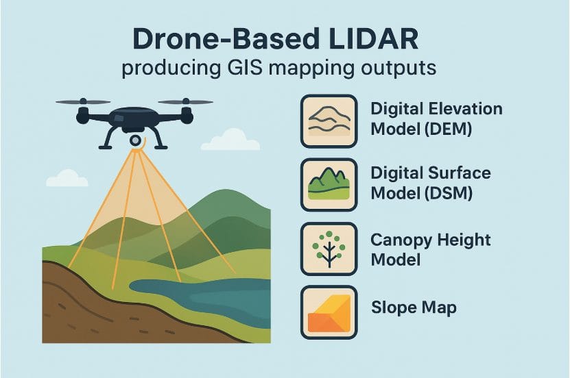
- Drones (UAVs) for aerial imagery and 3D mapping
- LIDAR scanners for capturing surface elevation data
- Environmental sensors for monitoring air, soil, water, and weather
Without these instruments, GIS would just be an empty map. With them? GIS becomes a living, breathing model of reality.
So, What Happens When This Data Enters GIS?
That’s where the magic happens. GIS takes raw measurements and turns them into:
- Interactive maps
- Trend analysis
- Predictive models
- Real-time monitoring systems
- 3D visualizations
- Spatial decision support tools
Imagine this flow: Instrument captures data → GIS stores, processes, and layers it → Output becomes actionable insight
How GIS Transforms Raw Data into Visual Insights
Once data is collected, GIS comes into play. Imagine receiving millions of data points, and then having the technology to seamlessly convert that information into detailed maps, reports, and models. GIS acts as the interpreter, turning complexity into clarity.
GIS outputs include:
- Digital Elevation Models (DEMs): Showing true ground surfaces.
- 3D Terrain Models: Helping engineers visualize and plan infrastructure.
- Environmental Mapping: Tracking changes in land use, pollution hotspots, and more.
- Spatial Analysis: Providing predictive insights for disaster management and urban development.
When paired with robust instrumentation, GIS transforms raw data into smart maps — making it possible for planners, engineers, and scientists to tackle real-world challenges head-on.
Real-Life Scenario: A Flood Risk Assessment Project
Let’s say a city is trying to prevent future flood disasters. Here’s how GIS and instrumentation come together:
- Surveyors use total stations and GNSS receivers to capture elevation data across neighborhoods.
- Drones fly over riverbanks to collect high-resolution aerial images.
- LIDAR scans reveal detailed 3D terrain models to identify low-lying areas.
- Weather sensors monitor rainfall and humidity trends.
All of this data is loaded into a GIS, where it’s analyzed and visualized on digital maps.
The result? Authorities can simulate flood scenarios, identify vulnerable zones, and design better drainage systems or evacuation routes — all thanks to this powerful tech combo.
Why It Matters?
The integration of instrumentation with GIS is more than just a technical process—it’s a revolution in how we interact with our world. Here’s why you should care:
- Enhanced Accuracy: Real-time data acquisition ensures that the maps and models we rely on are up-to-date.
- Informed Decision-Making: With detailed visualizations and analyses, governments, companies, and communities can make smarter decisions.
- Innovation in Action: This technology is at the heart of emerging industries like autonomous vehicles, precision agriculture, and smart city solutions.
Accurate instrumentation are seen as the eyes, ears, and hands that help build GIS analysis and outputs. Together, they make maps smarter, cities safer, farms more efficient, and disaster response more effective.


