Document

  1. Introduction

Agriculture remains one of the most important sectors of the Nigerian economy, employing a large percentage of the population and contributing significantly to national food security. However, traditional farming practices often face challenges such as low productivity, pest infestations, poor irrigation management, and inefficient monitoring of large farmlands. In recent years, drone technology, also known as Unmanned Aerial Vehicles (UAVs), has emerged as an innovative solution for modern agriculture. Drones provide farmers with aerial data, precision monitoring, and improved farm management tools. This report examines how drones are helping Nigerian farmers improve productivity, optimize farm operations, and enhance sustainable agricultural practices. Agriculture plays a vital role in Nigeria’s socio-economic development. The sector provides employment, supports rural livelihoods, and contributes significantly to the country’s Gross Domestic Product (GDP). Despite its importance, Nigerian agriculture still faces numerous challenges, such as:

  • Poor farm monitoring
  • Climate variability
  • Pest and disease outbreaks
  • Inefficient fertilizer and pesticide application
  • Limited access to modern agricultural technologies

With the advancement of precision agriculture, drone technology is becoming an effective tool for addressing many of these challenges. Agricultural drones can capture high-resolution aerial images, analyze crop health, monitor irrigation systems, and support data-driven decision-making. These capabilities are gradually transforming farming practices in Nigeria.

  1. Overview of Agricultural Drone Technology

Agricultural drones are unmanned aerial systems equipped with sensors, cameras, GPS receivers, and data processing software. These systems can fly over farmland and collect geospatial data used for agricultural analysis.

Typical components of agricultural drones include:

  • High-resolution RGB cameras
  • Multispectral sensors
  • Thermal imaging sensors
  • Global Positioning System (GPS)
  • Geographic Information System (GIS) integration

These technologies enable drones to capture precise information about farmland conditions, crop health, soil quality, and irrigation efficiency.

  1. Applications of Drones in Nigerian Agriculture

There are different areas of drone application in Nigerian agriculture, and they are outlined as follows:

3.1 Crop Monitoring and Health Assessment

One of the most significant uses of drones in Nigerian agriculture is crop monitoring. Farmers can use drones to regularly inspect their fields, monitor crop growth throughout the planting season, and monitor crop health as shown in Figure 1.

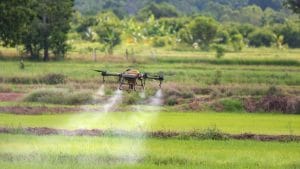
Figure 1: Drone Operation on Farmland

Drones equipped with high-resolution cameras and multispectral sensors capture detailed images of farmland. These images allow farmers to detect problems such as:

  • Pest infestations
  • Plant diseases
  • Nutrient deficiencies
  • Water stress
  • Uneven crop growth

By identifying these issues early, farmers can take corrective actions before the damage spreads across the entire farm. For example, sensors using NDVI (Normalized Difference Vegetation Index) can analyse plant health based on light reflection patterns, helping farmers quickly detect stressed crops.

Drones capture aerial images that reveal important details about crop conditions, including:

  • Plant growth patterns
  • Areas affected by pests or diseases
  • Nutrient deficiencies
  • Water stress

Using specialized software, these images can be analyzed through vegetation indices such as Normalized Difference Vegetation Index (NDVI), which helps farmers detect unhealthy crops before visible symptoms appear. Early detection allows farmers to take corrective measures promptly, preventing large-scale crop damage.

3.2 Precision Application of Fertilizers and Pesticides

Another critical application of drones is precision spraying of agrochemicals (Figure 2). Traditional spraying methods often involve manual labor or tractor-based systems that apply chemicals uniformly across the entire farm. This approach can result in:

  • Over-application of chemicals
  • Environmental pollution
  • Increased production costs

Drone spraying technology allows farmers to apply fertilizers, herbicides, and pesticides only where they are needed. This targeted application improves efficiency, reduces chemical waste, improves crop protection, protects soil and water from excessive chemicals. It also minimizes farmers’ exposure to harmful chemicals during manual spraying. Some Nigerian farmers have reported up to 30% savings on agrochemicals using drone spraying systems.

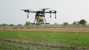
Figure 2:  Precision Spraying of Agrochemicals

3.3 Farm Mapping and Land Surveying

Drones are also widely used for mapping agricultural land and producing accurate farm maps (Figure 3). These maps help farmers understand the spatial characteristics of their farms, including slope, drainage patterns, and land use distribution. Such information is essential for planning irrigation systems, planting patterns, and soil conservation strategies. Drones are widely used to map farmland and create digital maps of agricultural fields. Using aerial imaging and GPS technology (or through aerial photogrammetry and GPS positioning), drones can:

  • Produce topographic maps of farmland
  • Measure field boundaries
  • Identify drainage patterns
  • Detect erosion-prone areas
  • Orthomosaic maps
  • Digital elevation models (DEM)

This information helps farmers plan irrigation systems, planting patterns, and farm expansion more effectively.

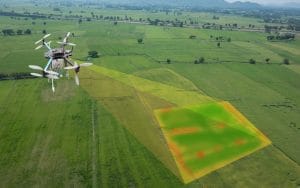
Figure 4: Farm Mapping and Land Surveying

3.4 Irrigation and Water Management

Water management is a major challenge for farmers in many parts of Nigeria, especially in dry regions. Drones equipped with thermal sensors can detect variations in soil moisture across farmland. Thermal imaging enables farmers to identify:

  • Areas experiencing water stress
  • Over-irrigated sections
  • Blocked irrigation channels
  • Uneven water distribution

By identifying these problems early through drones, farmers can adjust irrigation systems to ensure efficient water usage and prevent crop losses. This implies that the use of drones allows farmers to optimise irrigation and avoid wasting water, which improves crop growth and sustainability. Figure 4 shows a drone surveying a farmland.

3.5 Faster and More Efficient Farm Inspection

Manual farm inspection can be time-consuming, especially for large farms. Farmers often need several hours or days to inspect their entire fields.

Drones significantly reduce this effort by allowing farmers to:

  • Inspect hundreds of hectares within minutes
  • Monitor crop development frequently
  • Quickly detect problems affecting crop growth

Frequent monitoring ensures that farmers respond promptly to pests, diseases, and environmental stress factors.

3.6 Soil Analysis and Field Planning

Before planting crops, drones can help farmers conduct soil and terrain analysis. Aerial images collected by drones provide information about soil variability across farmland.

These data help farmers determine:

  • Suitable planting zones
  • Soil temperature
  • Soil moisture distribution/levels
  • Soil erosion risks
  • Nutrient distribution
  • Fertility variation within fields

Such information enables farmers to implement site-specific farming techniques, where different parts of the farm receive different treatments based on their soil conditions. it also helps farmers in determining the best areas for planting different crops and improving soil management strategies

  1. Conclusion

Drone technology is rapidly transforming agricultural practices in Nigeria by providing farmers with advanced tools for crop monitoring, precision spraying, land mapping, irrigation management, and soil analysis. These capabilities allow farmers to make informed decisions, reduce production costs, and increase crop yields. Although challenges such as cost and technical capacity remain, continued investment in agricultural technology and training will promote wider adoption of drones. Ultimately, the integration of drones into Nigerian agriculture represents a critical step toward achieving sustainable farming and improved food security.

RECENT ACTIVITIES AND PROJECT...

URABN HEAT ISLAND EFFECT IN CALABAR MUNICIPAL

URABN HEAT ISLAND EFFECT IN CALABAR MUNICIPAL

ANALYZING URBANIZATION TRENDS IN KANO STATE, NIGERIA USING NIGHTTIME LIGHTS REMOTE SENSING DATA

ANALYZING URBANIZATION TRENDS IN KANO STATE, NIGERIA USING NIGHTTIME LIGHTS REMOTE SENSING DATA

COMPREHENSIVE OFFSHORE SURVEILLANCE AND MARITIME INFRASTRUCTURE MONITORING

COMPREHENSIVE OFFSHORE SURVEILLANCE AND MARITIME INFRASTRUCTURE MONITORING

Comprehensive Aerial Survey and Mapping for Golf Course Asset Management at Lakowe Golf Lake

Comprehensive Aerial Survey and Mapping for Golf Course Asset Management at Lakowe Golf Lake

Professional Drone Training Program for Enhanced Corporate Security Operations at Sahara Group

Professional Drone Training Program for Enhanced Corporate Security Operations at Sahara Group

Advanced Aerial Topographic Survey and Mapping for Land Development in Ogun State

Advanced Aerial Topographic Survey and Mapping for Land Development in Ogun State

Precision RGB and Thermal Imaging Revolutionizes Solar Infrastructure Inspection In Enugu

Precision RGB and Thermal Imaging Revolutionizes Solar Infrastructure Inspection In Enugu

Advanced Drone-Based Topographic Survey for Precision Land Development Planning

Advanced Drone-Based Topographic Survey for Precision Land Development Planning

Mapping the Future: Comprehensive Area Survey Transforms Land Development in Akure

Mapping the Future: Comprehensive Area Survey Transforms Land Development in Akure

Precision Topographical Survey and Mapping for Smarter Infrastructure Planning

Precision Topographical Survey and Mapping for Smarter Infrastructure Planning

Precision Drone Volumetric Surveys: How Purechem Industries Optimized Mineral Stockpile Management

Precision Drone Volumetric Surveys: How Purechem Industries Optimized Mineral Stockpile Management

Advanced Mapping & Environmental Survey for Ilubirin Property, Lagos Island

Advanced Mapping & Environmental Survey for Ilubirin Property, Lagos Island

Unveiling the Invisible: LiDAR Technology Transforms Terrain Analysis in Abeokuta North

Unveiling the Invisible: LiDAR Technology Transforms Terrain Analysis in Abeokuta North

 DETAILED AERIAL, LAND SURVEY AND GIS ANALYSIS FOR ADVANCED REAL ESTATE DEVELOPMENT

 DETAILED AERIAL, LAND SURVEY AND GIS ANALYSIS FOR ADVANCED REAL ESTATE DEVELOPMENT

Professional Drone Mapping and GIS Training For ETA-ZUMA Mining Company

Professional Drone Mapping and GIS Training For ETA-ZUMA Mining Company

Installation of Intelligent Traffic Lights

Installation of Intelligent Traffic Lights

Geological Report on a Mining/Exploration Survey

Geological Report on a Mining/Exploration Survey

Drone Survey and Mapping of Shaishen Foods Limited

Drone Survey and Mapping of Shaishen Foods Limited

Lidar Topographic Mapping Project

Lidar Topographic Mapping Project

Geophysical/hydrogeophysical Studies for Groundwater Development

Geophysical/hydrogeophysical Studies for Groundwater Development

Togo Digital Terrain Model Project

Togo Digital Terrain Model Project

Drone Mapping of Parts of Lome Rail Line for Graceland Energy Located at Lome Togo

Drone Mapping of Parts of Lome Rail Line for Graceland Energy Located at Lome Togo

Drone/land Survey of Pure-chem Industrial Limited, Ogun State.

Drone/land Survey of Pure-chem Industrial Limited, Ogun State.

Drone Inspection/survey of Southern Lake Estate, Chevron, Lekki, Lagos State

Drone Inspection/survey of Southern Lake Estate, Chevron, Lekki, Lagos State

Anniversary-Workshop on the Application of Remote Sensing and Drone Technology in GIS -Abuja

Anniversary-Workshop on the Application of Remote Sensing and Drone Technology in GIS -Abuja

Topographic Mapping of Oyo State

Topographic Mapping of Oyo State

Topographic Mapping of Part of the Local Government Areas in Oyo State

Topographic Mapping of Part of the Local Government Areas in Oyo State

Topographic Mapping of Part of Kwara, Ekiti and Kogi State Local Government Area

Topographic Mapping of Part of Kwara, Ekiti and Kogi State Local Government Area

Political Map of South West, Nigeria Located in Nigeria

Political Map of South West, Nigeria Located in Nigeria

Topographic Mapping of Parts of Niger State Located at Niger State, Nigeria

Topographic Mapping of Parts of Niger State Located at Niger State, Nigeria

Topographic Mapping of Part of Kwara, Ekiti, and Kogi State Local Government Area Located in Nigeria

Topographic Mapping of Part of Kwara, Ekiti, and Kogi State Local Government Area Located in Nigeria

Topographic Mapping of Part of Kwara State Local Government Area Located at Kwara State Nigeria

Topographic Mapping of Part of Kwara State Local Government Area Located at Kwara State Nigeria

Flood Analysis of Amuwo-odofin Orthophoto.

Flood Analysis of Amuwo-odofin Orthophoto.

Site Inspection Using Drone of Water Corporation Located at Oke-aro Agege

Site Inspection Using Drone of Water Corporation Located at Oke-aro Agege

24,000 meter Lome Rail Line for Drone Mapping, Graceland Energy Located at Lome, Togo

24,000 meter Lome Rail Line for Drone Mapping, Graceland Energy Located at Lome, Togo

10 Drone Inspection Traffic Signal in Lagos

10 Drone Inspection Traffic Signal in Lagos

Lagos October 1st Free GIS Training Workshop

Lagos October 1st Free GIS Training Workshop

Osun state parcel project

Osun state parcel project

Drone Mapping & Vectorization Of Abu-allied Farm

Drone Mapping & Vectorization Of Abu-allied Farm

Proposal for aerial deployment, tracking and monitoring of threats in victoria island phase 1 and ikoyi phase 2, nigeria

Proposal for aerial deployment, tracking and monitoring of threats in victoria island phase 1 and ikoyi phase 2, nigeria

Jabi Lake Mall Solar Inspection – Abuja

Jabi Lake Mall Solar Inspection – Abuja

Ground Control and Drone Survey for Mast 3D Modeling

Ground Control and Drone Survey for Mast 3D Modeling

Telecom Drone 3D and 2D Modeling of Cellsite

Telecom Drone 3D and 2D Modeling of Cellsite

Free GIS Spatial Analysis Training (Lagos Branch)

Free GIS Spatial Analysis Training (Lagos Branch)

800 Building Plots Aerial Capture and Delineation for Database. Greenfield Estate

800 Building Plots Aerial Capture and Delineation for Database. Greenfield Estate

100 Hectares Aerial Survey with Differential GPS of High Accuracy

100 Hectares Aerial Survey with Differential GPS of High Accuracy

Protected: Nigeria Crime Report and Dashboard

Protected: Nigeria Crime Report and Dashboard

Drone Survey and Mapping – Victoria Island  Copy

Drone Survey and Mapping – Victoria Island Copy

Akwa-Ibom 500 Hectares Drone Survey and Mapping in Nigeria

Akwa-Ibom 500 Hectares Drone Survey and Mapping in Nigeria

Ground Control Establishment – Republic of the Niger – Kano, Kastina, Jigawa, Kaduna

Ground Control Establishment – Republic of the Niger – Kano, Kastina, Jigawa, Kaduna

Drone Survey and Mapping – Victoria Island

Drone Survey and Mapping – Victoria Island

Control Point Establishment – DGPS

Control Point Establishment – DGPS

Land Survey – Northern Nigeria

Land Survey – Northern Nigeria

Biodiversity Mapping – Sweden

Biodiversity Mapping – Sweden

Flood Impact Mapping – United Kingdom

Flood Impact Mapping – United Kingdom

M and E GIS Dashboard for Control Establishment Project

M and E GIS Dashboard for Control Establishment Project

Geodatabase Management System Training For National Boundary Commission

Geodatabase Management System Training For National Boundary Commission

Nigeria Topographic Map – Project

Nigeria Topographic Map – Project

Abuja Training on Introduction to GIS

Abuja Training on Introduction to GIS

200 Hectares Land and Drone Survey – Lagos Nigeria

200 Hectares Land and Drone Survey – Lagos Nigeria

Inspection of 30 hectares drainage

Inspection of 30 hectares drainage

Drainage Drone Mapping and Surveying in Lagos Nigeria

Drainage Drone Mapping and Surveying in Lagos Nigeria

GIS Cadastral Mobile Application

GIS Cadastral Mobile Application

Abuja Topographical Map – HD GIS Mapping

Abuja Topographical Map – HD GIS Mapping

Ground Topography Survey (Lagos Island)

Ground Topography Survey (Lagos Island)

2.7km2 Topography Survey in Snake Island

2.7km2 Topography Survey in Snake Island

GIS Masterclass

GIS Masterclass

Sokoto Contour Map

Sokoto Contour Map

NDVI Vegetation Assessment in Lagos State

NDVI Vegetation Assessment in Lagos State

Lagos drone training master class

Lagos drone training master class

Ifako drone topographic survey and mapping

Ifako drone topographic survey and mapping

CMD Lagos 3D mapping aerial modeling

CMD Lagos 3D mapping aerial modeling

GIS and Drone Masterclass

GIS and Drone Masterclass

Drone aerial survey and mapping – Lagos Island _ Somolu

Drone aerial survey and mapping – Lagos Island _ Somolu

Covid-19 | Nigeria Data Visualisation

Covid-19 | Nigeria Data Visualisation

Benue Flood Analysis

Benue Flood Analysis

Aerial photography Ile-Ife Osun State

Aerial photography Ile-Ife Osun State

Kenya Forest Project

Kenya Forest Project

Tunsun Consultants Ltd

Tunsun Consultants Ltd

Introduction To Gis In Maritime at the National Boundary Commission

Introduction To Gis In Maritime at the National Boundary Commission

Training on GIS and Drone Mapping (batch-4 & 5)

Training on GIS and Drone Mapping (batch-4 & 5)

Osun Flood Mapping

Osun Flood Mapping

Lahass International Limited

Lahass International Limited

Linguistic Association of Nigeria

Linguistic Association of Nigeria

West African Indexing Services

West African Indexing Services

Lagos Ikeja Road Network Map

Lagos Ikeja Road Network Map

LASU Land Regularisation Portal

LASU Land Regularisation Portal

Lingua Plus International

Lingua Plus International

Lagferry Web Route

Lagferry Web Route

YOU MAY ALSO LIKE...

COURSES

Explore Geoinfotech courses and establish a strong foundation of knowledge and skills to be productive with the latest Technology.

[Beginners to Professional] short training program

Our professional short courses deliver practical, hands-on training in GIS, Drone Operations, and Surveying, designed to build industry-ready skills in…

Find out more

NYSC Career Acceleration Program

The NYSC Career Acceleration Training Program is designed to equip corps members with industry-relevant geospatial and surveying skills that enhance…

Find out more

Differential GPS (DGPS) Land Surveying Training

Professional 2 weekends ▪ Field Experience 5.0 (100% Practical) ▪ Exam & CertificateFree Software and AppsHands on Practical and Field…

Find out more

Training on AutoCAD for Surveying and Mapping

Duration: 4 Weekends (Every Friday 2pm and Saturday 10am)
Package: Field Experience, 100% Hands-on practical, jotter, Biro and Software Others, Test, Exam and Certificate.

Find out more
Training Venue Available in,Lagos and Abuja100253Nigeria
+ Google Map